
80s return this week; Shower & t-storm chance Monday afternoon/evening
A hurricane could hit Florida on Tuesday
Go Deeper.
Create an account or log in to save stories.
Like this?
Thanks for liking this story! We have added it to a list of your favorite stories.


It was a very enjoyable Sunday.
Most of Minnesota and western Wisconsin had Sunday highs in the 70s and a few spots in western Minnesota topped 80 degrees. There were a few 60s near Lake Superior. Dew points were also very comfortable.
The Sunday high temperature at Minneapolis-St. Paul International Airport was 79 degrees, matching the Twin Cities average high temp for August 27.
Temperature trends
Monday highs will be in the 70s in roughly the northern third of Minnesota, with 80s elsewhere:
Turn Up Your Support
MPR News helps you turn down the noise and build shared understanding. Turn up your support for this public resource and keep trusted journalism accessible to all.

Tuesday high temps will be mainly in the 70s to the north, with some lower 80s elsewhere:

Twin Cities metro area highs are projected to be in the lower 80s on Wednesday, followed by mid 80s Thursday and upper 80s on Friday.
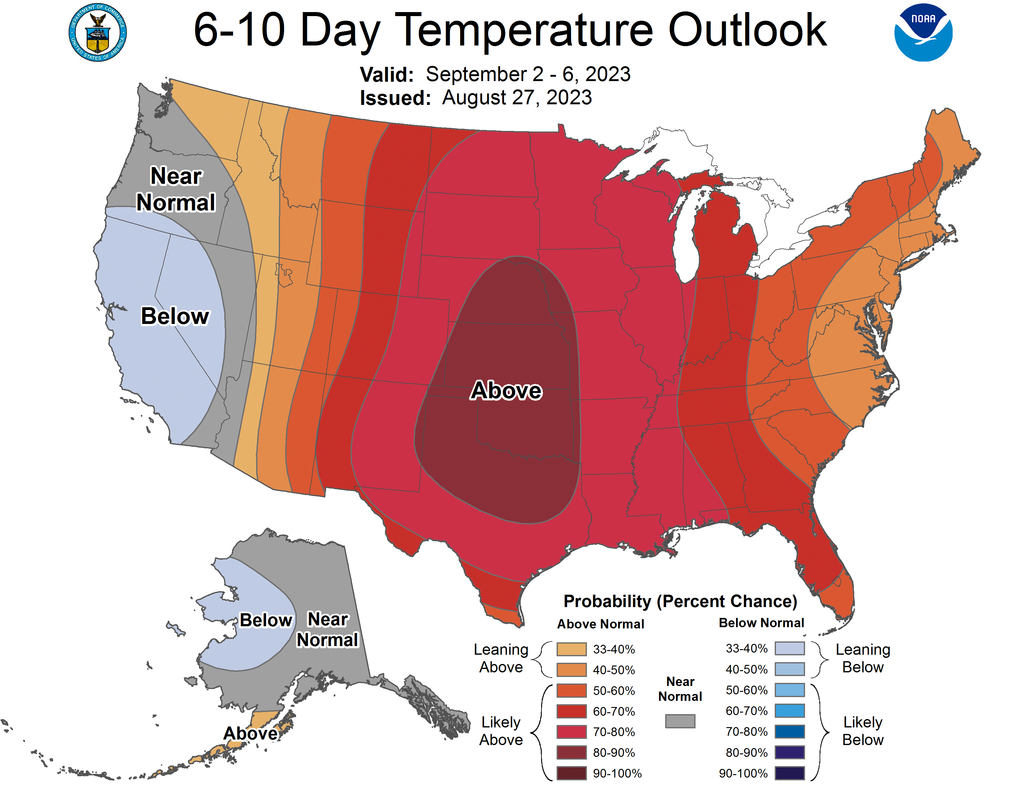
We could see metro area high temps around 90 degrees next weekend, then above-normal temperatures could linger into the start of the following week. Here’s the September 2 through September 6 temperature outlook from the NWS Climate Prediction Center:
Rain chances
Northern Minnesota and parts of central Minnesota and northwestern Wisconsin could see a few spotty showers Sunday evening.
Northeastern Minnesota will have a chance of scattered showers Monday morning, then scattered showers and thunderstorms are possible anywhere in eastern Minnesota and western Wisconsin Monday afternoon and early Monday evening. The window of opportunity for a few minutes of rain in the Twin Cities appears to be mainly late Monday afternoon into early Monday evening.
You can hear updated weather information for Minnesota and western Wisconsin on the MPR News network. Also check out the MPR News display of National Weather Service radar.
You can check these National Weather Service sites for updated weather info: Twin Cities, Duluth, La Crosse, Wis., Sioux Falls, S.D., and Grand Forks, N.D.
Hurricane could hit parts of Florida this week
The center of tropical storm Idalia will approach the western edge of Cuba on Monday, then Idalia is expected to become a hurricane in the gulf of Mexico Monday night.
The center of Idalia could approach the gulf coast of Florida late Tuesday or early Wednesday. Here’s the forecast track, plus the cone of uncertainty, for the center of Idalia:

This is the Sunday afternoon update on Idalia from the NWS National Hurricane Center:
BULLETIN Tropical Storm Idalia Advisory Number 5 NWS National Hurricane Center Miami FL AL102023 400 PM CDT Sun Aug 27 2023 ...STORM SURGE AND HURRICANE WATCHES ISSUED FOR PORTIONS OF THE FLORIDA GULF COAST... SUMMARY OF 400 PM CDT...2100 UTC...INFORMATION ---------------------------------------------- LOCATION...20.1N 85.5W ABOUT 95 MI...155 KM ESE OF COZUMEL MEXICO MAXIMUM SUSTAINED WINDS...40 MPH...65 KM/H PRESENT MOVEMENT...NE OR 40 DEGREES AT 3 MPH...6 KM/H MINIMUM CENTRAL PRESSURE...995 MB...29.39 INCHES WATCHES AND WARNINGS -------------------- CHANGES WITH THIS ADVISORY: A Storm Surge Watch has been issued for the Gulf coast of Florida from Chokoloskee to Indian Pass, including Tampa Bay. A Hurricane Watch has been issued for the Gulf coast of Florida from Englewood to Indian Pass, including Tampa Bay. A Tropical Storm Watch has been issued for the Gulf coast of Florida south of Englewood to Chokoloskee, and for the Dry Tortugas. SUMMARY OF WATCHES AND WARNINGS IN EFFECT: A Tropical Storm Warning is in effect for... * Yucatan Peninsula from Tulum to Rio Lagartos, including Cozumel * Pinar del Rio Cuba A Storm Surge Watch is in effect for... * Chokoloskee to Indian Pass Florida, including Tampa Bay A Hurricane Watch is in effect for... * Englewood to Indian Pass Florida, including Tampa Bay A Tropical Storm Watch is in effect for... * Isle of Youth Cuba * South of Englewood to Chokoloskee Florida * Dry Tortugas Florida A Storm Surge Watch means there is a possibility of life- threatening inundation, from rising water moving inland from the coastline, in the indicated locations during the next 48 hours. For a depiction of areas at risk, please see the National Weather Service Storm Surge Watch/Warning Graphic, available at hurricanes.gov. A Hurricane Watch means that hurricane conditions are possible within the watch area. A watch is typically issued 48 hours before the anticipated first occurrence of tropical-storm-force winds, conditions that make outside preparations difficult or dangerous. A Tropical Storm Warning means that tropical storm conditions are expected somewhere within the warning area. A Tropical Storm Watch means that tropical storm conditions are possible within the watch area. Interests along the southeastern U.S. coast should monitor the progress of this system. Additional watches and warnings will likely be required on Monday. For storm information specific to your area, please monitor products issued by your national meteorological service. DISCUSSION AND OUTLOOK ---------------------- At 400 PM CDT (2100 UTC), the center of Tropical Storm Idalia was located near latitude 20.1 North, longitude 85.5 West. Idalia is moving toward the northeast near 3 mph (6 km/h). A slow, possibly erratic, motion is expected overnight. A generally northward to north-northeastward motion at an increasing forward speed is expected on Monday and Tuesday. On the forecast track, the center will move over the eastern Gulf of Mexico on Monday and Tuesday, and approach the northeast Gulf coast late Tuesday. Maximum sustained winds are near 40 mph (65 km/h) with higher gusts. Strengthening is forecast, and Idalia is expected to become a hurricane over the southeastern Gulf of Mexico by early Tuesday. Additional strengthening is likely while Idalia approaches the northeastern Gulf coast. Tropical-storm-force winds extend outward up to 70 miles (110 km) from the center. The estimated minimum central pressure is 995 mb (29.39 inches). HAZARDS AFFECTING LAND ---------------------- Key messages for Idalia can be found in the Tropical Cyclone Discussion under AWIPS header MIATCDAT5 and WMO header WTNT45 KNHC, and on the web at hurricanes.gov/text/MIATCDAT5.shtml STORM SURGE: The combination of a dangerous storm surge and the tide will cause normally dry areas near the coast to be flooded by rising waters moving inland from the shoreline. The water could reach the following heights above ground somewhere in the indicated areas if the peak surge occurs at the time of high tide... Aucilla River, FL to Chassahowitzka, FL...7-11 ft Chassahowitzka, FL to Anclote River, FL...5-8 ft Ochlockonee River, FL to Aucilla River, FL...4-7 ft Anclote River, FL to Middle of Longboat Key, FL...3-5 ft Tampa Bay...3-5 ft Middle of Longboat Key, FL to Chokoloskee, FL...2-4 ft Charlotte Harbor...2-4 ft Indian Pass, FL to Ochlockonee River, FL...2-4 ft Chokoloskee, FL to East Cape Sable, FL...1-3 ft Florida Keys...1-2 ft The deepest water will occur along the immediate coast in areas of onshore winds, where the surge will be accompanied by large and dangerous waves. Surge-related flooding depends on the relative timing of the surge and the tidal cycle, and can vary greatly over short distances. For information specific to your area, please see products issued by your local National Weather Service forecast office. Storm surge will raise water levels by as much as 2 to 4 feet above normal tide levels along the southern coast of Pinar del Rio, Cuba. Near the coast, the surge will be accompanied by large waves. WIND: Tropical storm conditions are expected over portions of the warning area over the Yucatan Peninsula and western Cuba through Monday. Tropical storm conditions are possible within the watch area on the Isle of Youth on Monday. Hurricane conditions are possible within the hurricane watch area by late Tuesday or Wednesday, with tropical storm conditions possible by Tuesday. Tropical storm conditions are possible in the Dry Tortugas beginning late Monday and within the tropical storm watch area along the Florida Gulf coast on Tuesday. RAINFALL: Idalia is expected to produce the following rainfall amounts: Portions of the eastern Yucatan Peninsula: 2 to 4 inches, with isolated higher totals of 6 inches. Western Cuba: 3 to 6 inches, with isolated higher totals of 10 inches. Portions of the west coast of Florida, the Florida Panhandle, and southern Georgia: From Tuesday into Wednesday, 3 to 6 inches, with isolated higher totals of 10 inches. Heavy rainfall is also likely to spread into portions of the Carolinas by Wednesday into Thursday. This rainfall may lead to flash and urban flooding, and landslides across western Cuba. Scattered flash and urban flooding can also be expected across portions of the west coast of Florida, the Florida Panhandle and portions of the Southeast U.S. by Tuesday into Thursday.
The National Hurricane Center will issue updates on Idalia every three hours or so.
Programming note
You can hear my live weather updates on MPR News at 7:35 a.m., 9:35 a.m. and 4:39 p.m. each Saturday and Sunday.

