
Comfortable Sunday temps; 80s return this week
Rain chances north on Sunday
Go Deeper.
Create an account or log in to save stories.
Like this?
Thanks for liking this story! We have added it to a list of your favorite stories.


We’ll enjoy comfortable temperatures and dew points Sunday afternoon.
Most of Minnesota and western Wisconsin will see Sunday highs in the 70s. Parts of southwestern Minnesota will reach the lower 80s. Some spots in Lake County and Cook County that are close to Lake Superior will have highs in the 60s.
Sunday afternoon dew points will be in the comfortable 50s in most areas.
Temperature trends
Monday highs will be in the 70s in roughly the northern third of Minnesota, with mainly 80s elsewhere:
Turn Up Your Support
MPR News helps you turn down the noise and build shared understanding. Turn up your support for this public resource and keep trusted journalism accessible to all.

Tuesday highs will be in the 70s from north-central and northeastern Minnesota into western Wisconsin, with 80s elsewhere:

Twin Cities metro area highs are projected to reach the lower 80s Tuesday and Wednesday, followed by mid 80s Thursday and upper 80s on Friday.
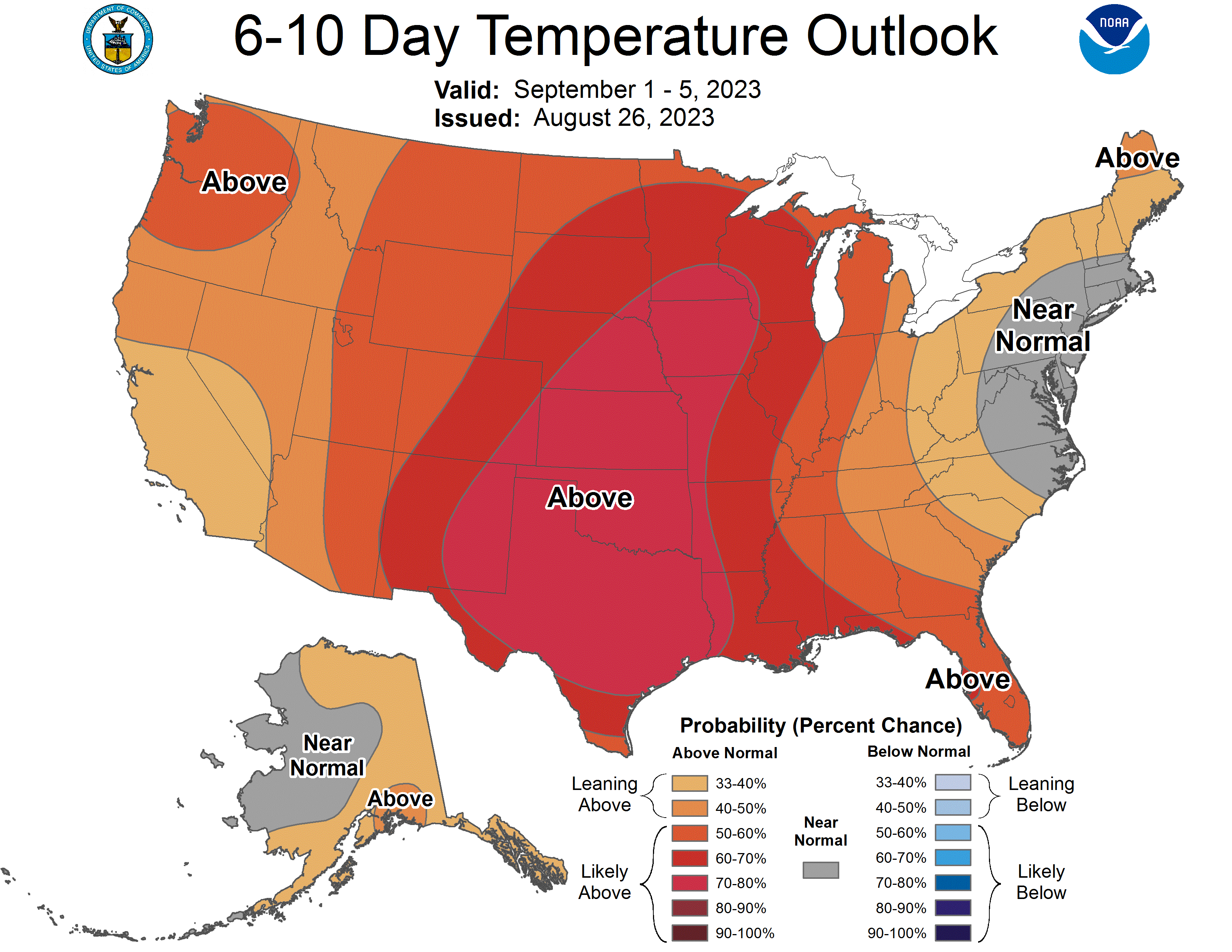
Above-normal temperatures could then linger into next weekend and the start of the following week, according to the temperature outlook from the NWS Climate Prediction Center:
Shower chance update
Parts of northern Minnesota have seen scattered showers Sunday morning. That shower chance lingers into early afternoon.
An approaching low pressure system could kick off some additional scattered showers in northwestern and north-central Minnesota later Sunday afternoon into Sunday evening. An isolated thunderstorm is also possible in those areas. Northeastern Minnesota and parts of central Minnesota and northwestern Wisconsin could see a passing shower Sunday evening.
You can hear updated weather information for Minnesota and western Wisconsin on the MPR News network. Also check out the MPR News display of National Weather Service radar.
Spotty rain chance Monday
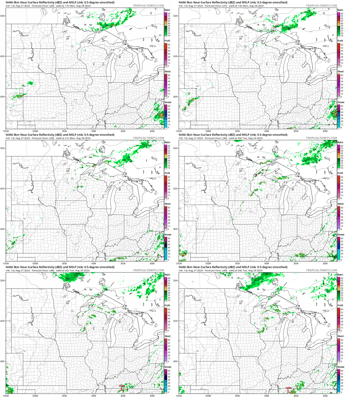
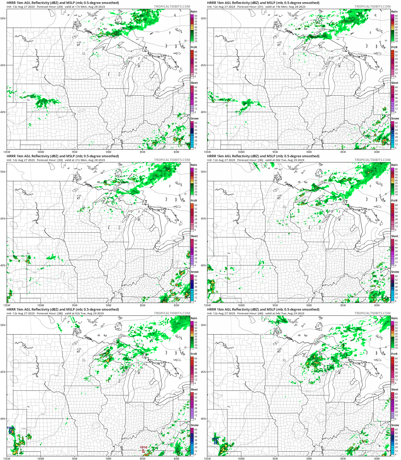
Scattered showers and an isolated thunderstorm could develop in eastern Minnesota and western Wisconsin from mid-to-late afternoon on Monday, then continue into Monday evening.
The National Oceanic and Atmospheric Administration’s North American Mesoscale (NAM) forecast model shows the potential rainfall pattern from noon Monday to 11 p.m. Monday:
Here’s NOAA’s High Resolution Rapid Refresh (HRRR) model for that same time period:
Check forecast updates.
Minnesota State Fair weather
How often does it rain during the Minnesota Sate Fair? The Minnesota State Climatology Office has posted some interesting facts about Minnesota State Fair weather.
Here’s an excerpt from that post:
On average it rains about three to four days during the Fair's 12-day run. The wettest Fair was in 1977 with 9.48 inches, and the driest Fair was 2003 with only .02 inch of rain.
The largest rain event in the State Fair's history was August 30, 1977. At 8:20pm heavy rains hit the State Fairgrounds. The U of M St. Paul Campus climate observatory one mile north of the Fairgrounds reported 4.06 inches of rain. This caused some of the worst street flooding seen at the Fairgrounds. The bulk of the rain fell in a 3 1/2 hour period from 8:15pm to 11:45pm. The grandstand show was cancelled, and people had great difficulty trying to leave the Fair. The Twin Cities International Airport saw 7.28 inches from this event, second all-time only to the July 1987 "Superstorm" total of 10.00 inches. People driving on I-94 leaving the Fair found water "up to their hood ornaments" in low areas under bridges.
Dry weather is expected at the Minnesota State Fair today.
Programming note
You can hear my live weather updates on MPR News at 7:35 a.m., 9:35 a.m. and 4:39 p.m. each Saturday and Sunday.

