
Chilly temps linger; snow update for late Monday into early Tuesday
Fall color update for leaf-peepers
Go Deeper.
Create an account or log in to save stories.
Like this?
Thanks for liking this story! We have added it to a list of your favorite stories.


Our Sunday high temps will be more typical of late November than late October.
The average Twin Cities high temp is 51 degrees on Oct. 29. Metro area highs are forecast to reach the upper 30s Sunday afternoon. A few spots in the metro area could touch 40 degrees.
Most of Minnesota and western Wisconsin will top out in the 30s Sunday afternoon, with 20s in parts of far northern Minnesota.
Hard freeze overnight
Low temps late Sunday night and early Monday will be in the 20s across much of Minnesota and western Wisconsin, with teens in northern Minnesota:
Turn Up Your Support
MPR News helps you turn down the noise and build shared understanding. Turn up your support for this public resource and keep trusted journalism accessible to all.

Portions of southeastern Minnesota along the Mississippi River Valley will see a hard freeze for the first time this autumn. A freeze warning has been posted for Sunday night into early Monday for blue-shaded counties along the river:

Here are details of the freeze warning:
URGENT - WEATHER MESSAGE National Weather Service La Crosse WI 341 AM CDT Sun Oct 29 2023 IAZ011-030-MNZ079-088-096-WIZ032-033-041-053>055-061-292215- /O.NEW.KARX.FZ.W.0002.231030T0100Z-231030T1300Z/ Allamakee-Clayton-Wabasha-Winona-Houston-Buffalo-Trempealeau- La Crosse-Vernon-Crawford-Richland-Grant- Including the cities of Waukon, Elkader, Wabasha, Winona, Caledonia, Alma, Arcadia, Whitehall, La Crosse, Viroqua, Prairie Du Chien, Richland Center, and Platteville 341 AM CDT Sun Oct 29 2023 ...FREEZE WARNING IN EFFECT FROM 8 PM THIS EVENING TO 8 AM CDT MONDAY... * WHAT...Sub-freezing temperatures as low as 21 expected. * WHERE...Counties along the Mississippi and Wisconsin River Valleys in northeast Iowa, southeast Minnesota and southwest and west central Wisconsin. * WHEN...From 8 PM this evening to 8 AM CDT Monday. * IMPACTS...Frost and freeze conditions will kill crops, other sensitive vegetation and possibly damage unprotected outdoor plumbing. PRECAUTIONARY/PREPAREDNESS ACTIONS... Take steps now to protect tender plants from the cold. To prevent freezing and possible bursting of outdoor water pipes they should be wrapped, drained, or allowed to drip slowly. Those that have in-ground sprinkler systems should drain them and cover above- ground pipes to protect them from freezing.
Temperature trends
Monday highs will be mainly in the 30s, with some 20s in far northern Minnesota:

Tuesday high temps will also be mainly in the 30s. Temperatures will dip into the 20s in many areas during trick-or-treat time Tuesday evening:

Twin Cities metro area high temps are projected to be around 40 degrees on Wednesday, followed by lower 40s Thursday and upper 40s on Friday.
Snow chances
Far southeastern Minnesota could see a stray flurry into early Sunday afternoon. Portions of far northern Minnesota could see a passing snow flurry Sunday afternoon or evening.
A low pressure system is expected to spread snow into northwestern Minnesota Monday morning, then the snow coverage expands to cover more of northern Minnesota Monday afternoon. Periods of snow are possible in much of Minnesota and western Wisconsin Monday evening into early Tuesday.
The National Oceanic and Atmospheric Administration’s North American Mesoscale forecast model shows the potential precipitation pattern from noon Monday to 9 a.m. Tuesday:
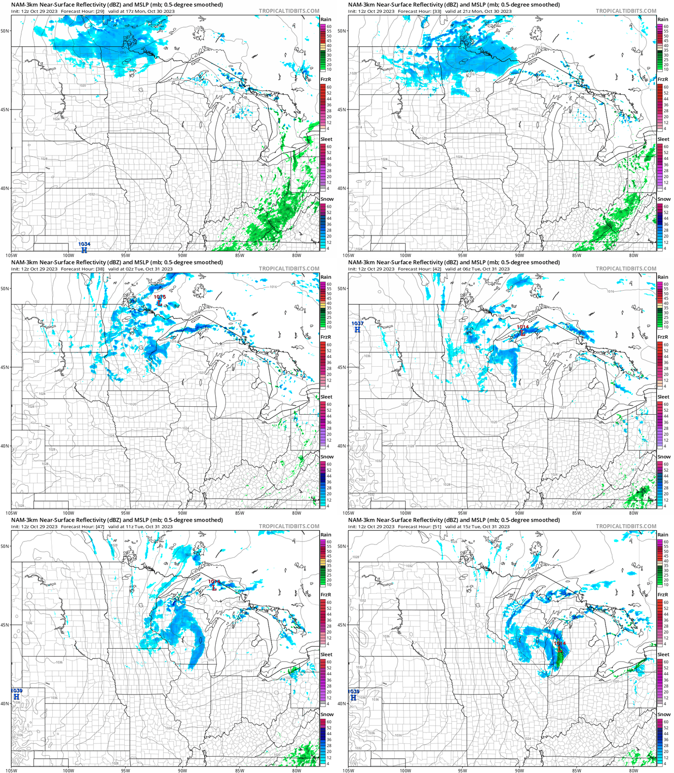
Snow totals of 1 to 2 inches are showing up in some forecast models for portions of northern Minnesota and northwestern Wisconsin. Lower snow amounts are indicated elsewhere in Minnesota and in west-central Wisconsin by Tuesday morning.
You can hear updated weather information for Minnesota and western Wisconsin on the MPR News network. Also check out the MPR News display of National Weather Service radar. Due to dry air at lower levels, not all of the precipitation that shows up on radar will be reaching the ground.
Weather nugget
The sun will set at 6:06 p.m. today in the Twin Cities. Daylight saving time ends next Sunday at 2 a.m., so Twin Cities sunset will be at 4:56 p.m. central standard time next Sunday.
Programming note
You can hear my live weather updates on MPR News at 7:35 a.m., 9:35 a.m. and 4:39 p.m. each Saturday and Sunday.

