Finally, winter: Colder with snow chances ahead

Temps much closer to average over the next week

Snowfall projection for Minnesota
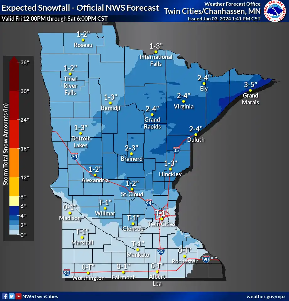
Snowfall projection for Minnesota through Saturday
National Oceanic and Atmospheric Administration

Get ready for a more typical January forecast, Minnesota.

Our weather pattern is finally taking a turn toward a more wintry picture. Changes in the upper air and surface weather patterns will finally bring much colder air and snow chances to Minnesota.

The first flakes are flying across much of northern Minnesota this Wednesday. Light snow has caused some slick roads in spots from near Fargo-Moorhead to Duluth.

A more persistent system will arrive across northern Minnesota Friday and Saturday. This Canadian model loop shows snow increasing across Minnesota between 6 p.m. Friday and 6 p.m. Saturday:

Create a More Connected Minnesota

MPR News is your trusted resource for the news you need. With your support, MPR News brings accessible, courageous journalism and authentic conversation to everyone - free of paywalls and barriers. Your gift makes a difference.

Canadian model
Canadian model between 6 p.m. Friday and 6 p.m. Saturday
Environment Canada, via Tropical Tidbits

Overall snowfall accumulations look light for the Twin Cities with this system, but more significant snowfall will occur as you move north of the Twin Cities.

Snowfall projection
Snowfall projection
National Oceanic and Atmospheric Administration

Cold next

It will gradually turn colder across Minnesota over the next week.

Highs on Thursday will hover mostly in the 20s. The normal high and low for the Twin Cities Thursday are 24 and 10 degrees.

Forecast high temperatures Thursday
NOAA

Highs will return to the lower 30s as we move into the weekend across southern Minnesota.

Forecast high temperatures Friday
NOAA

But much colder air begins to move into northern Minnesota next week.

Forecast high temperatures Sunday
NOAA

Forecast models still favor the potential for a widespread subzero outbreak late next week into the weekend of Jan. 13-14.

Stay tuned.