Snow again: Winter storm warning for North Shore

Light snow for most of Minnesota through Thursday night

Snowfall projection for northeast Minnesota
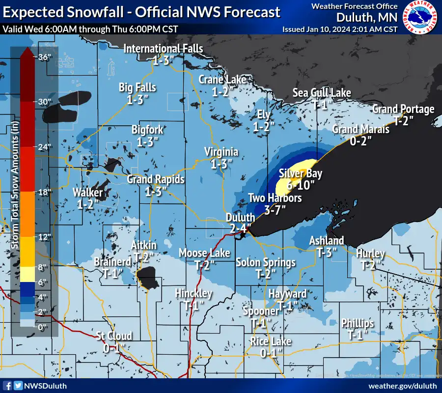
Snowfall projection for northeast Minnesota.
NOAA

Winter is finally ripening across Minnesota.

Our latest salvo includes a winter storm warning for much of the North Shore region through 6 p.m. Thursday. A Clipper gliding across Minnesota with an easterly surface wind flow will turn on lake-effect snow along Lake Superior. Parts of the North Shore region could pick up double-digit snowfall totals by Thursday night.

Winter storm warnings and advisories
Winter storm warnings and advisories.
NOAA

Here are the winter storm warning details via the Duluth NWS Office.

Including the cities of Two Harbors and Silver Bay

2:37 a.m. CST Wednesday:

Winter storm warning in effect from noon Wednesday to 6 p.m. Thursday.

  • What: Heavy lake effect snow expected. Total snow accumulations of 4 to 9 inches. Locally higher amounts in excess of 10 inches will be possible.

  • Where: Southern Lake County.

  • When: From noon today to 6 PM CST Thursday.

  • Impacts: Travel could be very difficult. The hazardous conditions could impact the morning or evening commute.

  • Additional details: There is a favorable setup for a stationary lake effect band to set up over southern Lake County. Locations that end up under this band can expect rapid accumulating snow.

Lighter snow across Minnesota

Our Wednesday Clipper will bring mostly light snow to the rest of Minnesota. Snow will cause some slick spots on roads through tonight, but overall snowfall totals will remain light across most of the state away from the North Shore.

Create a More Connected Minnesota

MPR News is your trusted resource for the news you need. With your support, MPR News brings accessible, courageous journalism and authentic conversation to everyone - free of paywalls and barriers. Your gift makes a difference.

Snowfall projection for Minnesota
Snowfall projection for Minnesota.
NOAA

Season’s first subzero outbreak this weekend

A major winter storm will dump more heavy snow from Iowa through the Chicago area Friday. That system may bring more light snow to southern Minnesota on Friday. Behind it, a major blast of Arctic air will bring the season’s coldest air mass so far.

Overnight lows will dip well below zero this weekend into early next week.

Forecast low temperatures Sunday morning 2
Forecast low temperatures Sunday morning.
NOAA

Daytime high temperatures will struggle to reach zero across southern Minnesota.

Forecast high temperatures Sunday
Forecast high temperatures Sunday.
NOAA

Get ready for the coldest air of winter so far by this weekend.