Updraft®

Severe storms risk and flood watches Tuesday

Expect high winds, hail, torrential rain; tornadoes possible

Flood watch
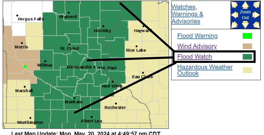
Flood watch for much of Minnesota Tuesday
National Oceanic and Atmospheric Administration, Twin Cities National Weather Service office

The forecast models have upped the ante for severe weather in Minnesota on Tuesday. A flood watch has been added to the mix Tuesday for most of central and northeastern Minnesota, including the greater Twin Cities area.

Multiple waves of rain and thunderstorms will sweep across Minnesota from late Monday night through Tuesday. The first wave of storms focuses on southern Minnesota Monday night. Then multiple waves of storms roam our landscape as the low moves through Minnesota Tuesday.

There is a slight risk for severe storms across southern Minnesota Monday night, a marginal risk for the Twin Cities. The highest chance for severe weather is south of the Twin Cities Monday night across southeastern Minnesota.

Severe weather risk areas 2
Severe weather risk areas through Monday night
NOAA, Twin Cities National Weather Service

The National Oceanic and Atmospheric Administration’s latest High-Resolution Rapid Refresh model run as of late Monday afternoon shows scattered storms developing across southern Minnesota Monday evening. The best chance for storms around the Twin Cities favors the hours after about 10 p.m. through midnight.

NOAA HRRR model 2
High-Resolution Rapid Refresh model between 7 p.m. Monday and 1 a.m. Tuesday
NOAA, via Tropical Tidbits

Stormy Tuesday

To call it Stormy Tuesday may be an understatement. Multiple waves of storms will rumble across Minnesota Tuesday. The first wave is likely to roll from southern Minnesota into the Twin Cities Tuesday morning.

We may catch a break in between storm waves through the midday hours. But a second wave of storms is likely to develop in southern Minnesota in the early afternoon hours and race northeast into the greater Twin Cities area by late afternoon into Tuesday evening.

NOAA’s latest NAM 3 km model shows the two main storm waves riding northeast Tuesday:

NOAA NAM 3 km model 2
North American Mesoscale 3 km model between 7 a.m. and 7 p.m. Tuesday
NOAA, via Tropical Tidbits

Severe risk

Much of southeastern Minnesota into Wisconsin is under an enhanced (Category 3 of 5) severe risk zone Tuesday. The Twin Cities is under a slight (Category 2 of 5) risk area with a marginal severe risk as you move north and west.

Severe weather risk areas
Severe weather risk areas Tuesday
NOAA, Twin Cities National Weather Service office

All modes of severe weather are possible Tuesday. That means severe weather watches and warnings are likely. Damaging wind and hail, flooding rainfall, and even a few strong tornadoes are possible especially south and east of the Twin Cities.

Flood watch

This system is dragging a deep fetch of tropical moisture from the Gulf of Mexico. That means storms will produce torrential downpours at times. In areas that see multiple storms stall, flash flooding is a real possibility.

Including the cities of Stillwater, St Paul, Monticello, Hutchinson, Center City, Elk River, Gaylord, Litchfield, Little Falls, Blaine, Chanhassen, Hudson, St Cloud, Sauk Rapids, Chaska, River Falls, Princeton, Shakopee, Hastings, Cambridge, Osceola, Victoria, Minneapolis, and Mora

308 PM CDT Mon May 20 2024

...FLOOD WATCH REMAINS IN EFFECT FROM TUESDAY MORNING THROUGH LATE TUESDAY NIGHT...

* WHAT...Flash flooding caused by excessive rainfall continues to be possible.

* WHERE...Portions of Minnesota, including the following areas, Anoka, Benton, Carver, Chisago, Dakota, Hennepin, Isanti, Kanabec, McLeod, Meeker, Mille Lacs, Morrison, Ramsey, Scott, Sherburne, Sibley, Stearns, Washington and Wright and Wisconsin, including the following areas, Pierce, Polk and St. Croix.

* WHEN...From Tuesday morning through late Tuesday night.

* IMPACTS...Excessive runoff may result in flooding of rivers, creeks, streams, and other low-lying and flood-prone locations. Flooding may occur in poor drainage and urban areas.

The flood watch includes most of northeastern Minnesota.

Flood watch for northeast Minnesota
Flood watch for northeastern Minnesota Tuesday
Duluth National Weather Service office

Including the cities of Pine River, Superior, Hill City, Aitkin, Pine City, Hinckley, Walker, Brainerd, Duluth, and Grantsburg

304 PM CDT Mon May 20 2024

..FLOOD WATCH IN EFFECT FROM TUESDAY MORNING THROUGH WEDNESDAY MORNING...

* WHAT...Flash flooding caused by excessive rainfall is possible.

* WHERE...In Minnesota, Crow Wing, Pine, Carlton, southern St. Louis, Aitkin and Cass Counties and Wisconsin, Burnett and Douglas Counties. This includes the Tribal Lands of the St. Croix Band in Burnett County, the Fond du Lac Band and the Mille Lacs Band, Big Sandy Lake, East Lake, Hinckley and, Lena Lake areas.

* WHEN...From Tuesday morning through Wednesday morning. * IMPACTS...Excessive runoff may result in flooding of rivers, creeks, streams, and other low-lying and flood-prone locations.

Rainfall totals of 2 to 4 inches appear likely in and near the watch zone. A few forecast models crank out local rainfall totals of 4 to 8 inches Tuesday!

NOAA NAM 3 km model precipitation output
North American Mesoscale 3 km model precipitation output Thursday
NOAA, via Pivotal Weather

So get ready for an active Tuesday. We may see multiple types of severe weather.