Updraft® - Minnesota Weather News

60 degrees warmer next week? Highs in the 40s look likely

Signs February may deliver more snow to Minnesota

NOAA 6 to 10-day temperature outlook
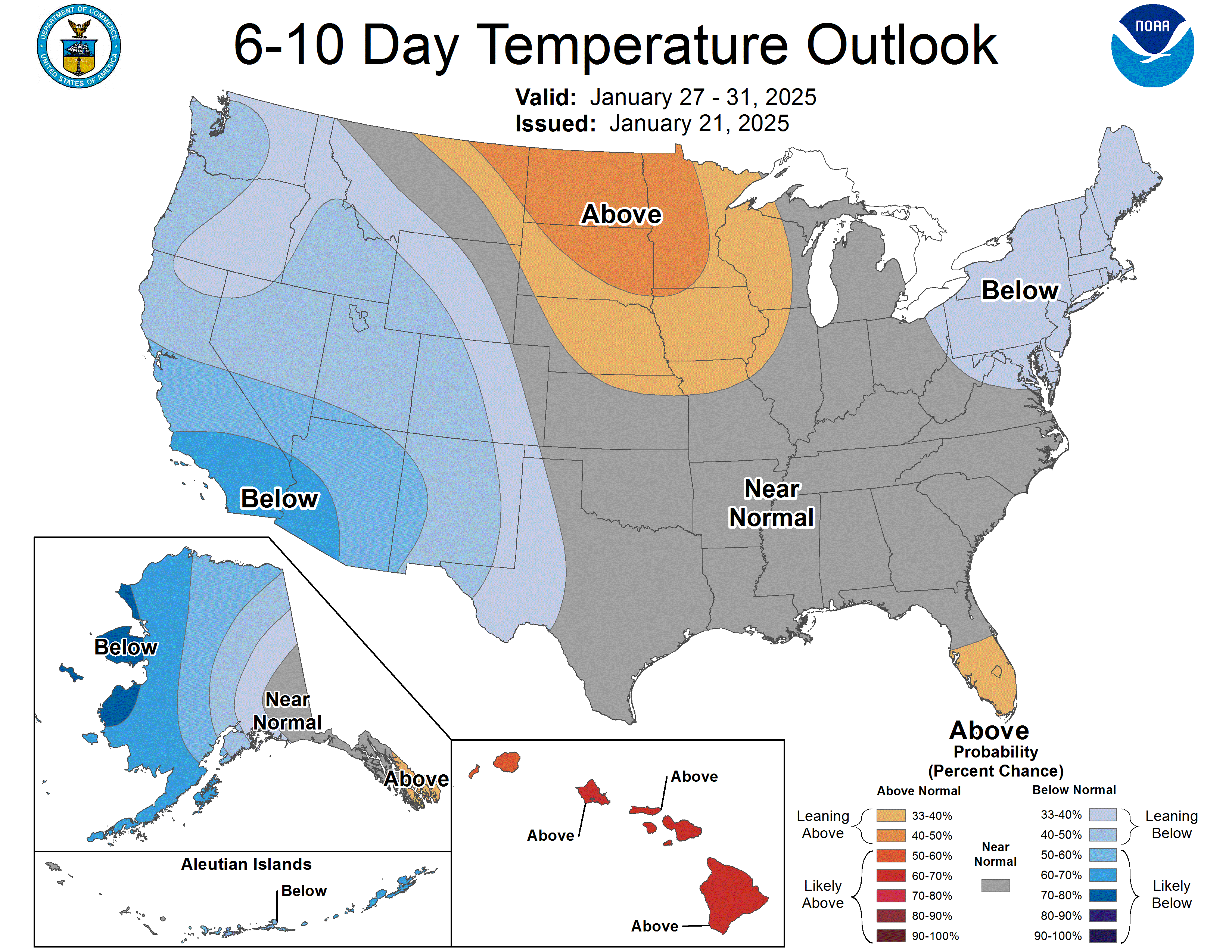
Six to 10-day temperature outlook
National Oceanic and Atmospheric Administration

We made it.

I’m 99.9 percent sure Tuesday morning’s low temperature of minus 19 degrees at Minneapolis-St. Paul International Airport will stand as the coldest temperature this winter. We recover gradually through the 20s on Wednesday.

Wednesday's expected highs
Wednesday will see much of the region into the 20s
National Oceanic and Atmospheric Administration

Thursday brings one more temperature speed bump with highs in the teens. Temperatures will return to the seasonable 20s for most of Minnesota from Friday through Sunday.

Friday's expected highs
Friday features highs in teens and 20s
National Oceanic and Atmospheric Administration

January thaw, part 2

Next week will likely bring a second January thaw to Minnesota. Forecast models favor a westerly flow and a mild Pacific air mass blowing in from the west.

Highs on Monday will ease toward 30 degrees in the south. By Tuesday, the American and European models crank out temperatures in the lower 40s for the Twin Cities.

NOAA GFS temperature output
Global Forecast System temperature output for 6 p.m. Tuesday Jan. 28
NOAA, via Tropical Tidbits

On the map below, the European Centre for Medium-Range Weather Forecasts model suggests another pulse of mild air as we move into the first weekend of February!

European model (ECMWF) temperature forecast
Temperature forecast for Feb. 2
European Centre for Medium-Range Weather Forecasts, via Pivotal Weather

February snow?

The last half of La Niña winters tend to produce more snowfall in Minnesota than the first half. There are some signs that the storm track could begin moving closer to Minnesota next month.

The National Oceanic and Atmospheric Administration’s three-month precipitation outlook favors near-normal precipitation across most of Minnesota:

NOAA 3 month precipitation outlook
Three-month precipitation outlook
NOAA

NOAA’s Global Forecast System model is starting to hint at possible snow systems tracking through parts of Minnesota the first week of February.

NOAA GFS model
Global Forecast System model Feb. 3-6
NOAA, via Tropical Tidbits

The 30-year normal February snowfall for the Twin Cities is 9.5 inches, so the bar is low after recording just 1.7 inches of snow so far in January in the Twin Cities. But even normal snowfall in February will feel a lot more like winter around here.

Stay tuned.

Volume Button
Volume
Now Listening To Livestream
MPR News logo
On Air
All Things Considered with Ari Shapiro