
Record smoke front slams the Twin Cities and much of Minnesota
Sunnier skies, much less smoke, pleasant temps Wednesday

Go Deeper.
Create an account or log in to save stories.
Like this?
Thanks for liking this story! We have added it to a list of your favorite stories.


Our latest Canadian wildfire front produced choking smoke levels across much of Minnesota Tuesday morning:

Air quality readings for fine particulate matter from smoke (PM 2.5) in the Twin Cities peaked around 272 micrograms per cubic meter of air Tuesday morning. Here’s the data for the Minneapolis East Phillips neighborhood:

Tuesday's air quality index was comparable to the record set in July 2021. We’ll have to see where we land pending final data from the Minnesota Pollution Control Agency.

Air quality readings Tuesday afternoon are not as bad as Tuesday morning but still unhealthy across most of eastern Minnesota.
Turn Up Your Support
MPR News helps you turn down the noise and build shared understanding. Turn up your support for this public resource and keep trusted journalism accessible to all.
Tuesday’s AQI numbers are not the worst ever recorded in Minnesota. In 2021, I wrote about the incredible AQI index of 422 in St Cloud:
Air quality monitors in Minnesota recorded the highest particulate readings on record Thursday, according to data from the Minnesota Pollution Control Agency. Most MPCA monitors came online in 2000.
The air quality monitor at St. Cloud hit an astounding 422 micrograms per cubic meter at 11 a.m. Thursday.
The St. Cloud reading breaks the record set a couple of hours earlier at Brainerd of 401 micrograms per cubic meter. Both readings broke the record set in last week’s smoke event at Red Lake of 397 micrograms per cubic meter.
An air quality alert remains in effect until noon Wednesday:
Air quality is expected to reach the red AQI category in east central, southeast, and northeast Minnesota, which is unhealthy for everyone.
The air quality alert issued by the Minnesota Pollution Control Agency (MPCA) remains in effect until noon on Wednesday, June 4. The affected area includes the Twin Cities metro area, Brainerd, Alexandria, Albert Lea, Marshall, Worthington, Rochester, Hinckley, St. Cloud, Winona, Mankato, International Falls, Two Harbors, Hibbing, Ely, Duluth, and the Tribal Nations of Upper Sioux, Mille Lacs, Prairie Island, Leech Lake, Red Lake, Grand Portage, and Fond du Lac. Northwest Minnesota is no longer in the alert.
A band of very heavy smoke from Canadian wildfires continues to move southeast across Minnesota and has reached south central and northeast Minnesota Tuesday morning. Measured fine particle levels will be highest Tuesday morning from the Twin Cities to Rochester. Air quality may reach the Purple (Very Unhealthy) air quality index (AQI) category for a few hours Tuesday morning. Air quality will worsen across southeast Minnesota Tuesday as the smoke reaches the corner of the state. As the smoke continues to move across the state Tuesday, air quality will slowly improve from northwest to southeast for the remainder of the alert area. The smoke is expected to leave the state by Wednesday at noon.
East central, southeast, and northeast Minnesota: Fine particle levels are expected to reach the red air quality index (AQI) category, a level considered unhealthy for everyone. This area includes the Twin Cities metro, Albert Lea, Rochester, Hinckley, St. Cloud, Winona, Mankato, Two Harbors, Hibbing, Ely, Duluth, and the Tribal Nations of Prairie Island, Mille Lacs, Upper Sioux, Grand Portage, and Fond du Lac. In the red area, sensitive groups should avoid prolonged or heavy exertion and limit time spent outdoors. Everyone should limit prolonged or heavy exertion and time spent outdoors.
Western, central, and north central Minnesota: Fine particle levels are expected to reach the orange air quality index (AQI) category, a level considered unhealthy for sensitive groups. This area includes Brainerd, Alexandria, Marshall, Worthington, International Falls, and the Tribal Nations of Upper Sioux, Mille Lacs, Leech Lake, and Red Lake. In the orange area, sensitive groups should limit prolonged or heavy exertion and time spent outdoors.
Air quality improves Wednesday
Our latest smoke event eases overnight into Wednesday. The front that brought our most concentrated smoke plume drifts east overnight. An air mass with much less smoke drifts our way Wednesday.
The National Oceanic and Atmospheric Administration’s High-Resolution Rapid Refresh smoke product shows the smoke plume moving out of the Twin Cities and eastern Minnesota by around midnight through the overnight hours into Wednesday.
The forecast model loop below runs between 4 p.m. Tuesday and 6 a.m. Wednesday.
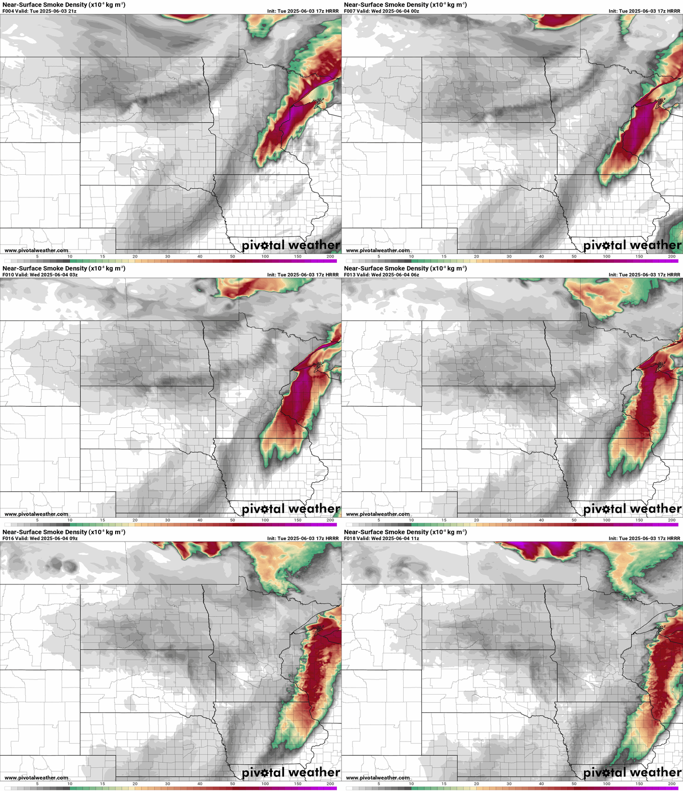
Expect sunnier skies, much less smoke, and pleasantly mild temperatures across Minnesota Wednesday!

Canadian wildfire smoke outlook for Minnesota
There are still hundreds of large blazes burning across central and western Canada.

Forecast models bring some rainfall into the fire zones over the next 10 days. Some areas may receive 1 to 2 inches of rain in the next 10 days. That won’t extinguish all the fires, but it may suppress fire activity and smoke output in some areas.
Unless we see a transition to a much wetter weather pattern across Canada I expect we will see additional wildfire smoke episodes across Minnesota this summer.

