
Breathing easier: Better air quality and bluer skies ahead
Rain chances increase late Thursday; more smoke possible Sunday

Go Deeper.
Create an account or log in to save stories.
Like this?
Thanks for liking this story! We have added it to a list of your favorite stories.


We’re breathing easier across Minnesota this Wednesday. Our trademark Minnesota summer blue sky is back for a change. What a concept.
Air quality across Minnesota Wednesday is in the range of moderate to good. The forecast calls for mainly good air quality into the upcoming weekend. A couple of smoky swipes may clip parts of northern Minnesota this week. (See the map above.)
Sunday’s passing cold front could drag down more Canadian wildfire smoke into Minnesota. Here’s the latest forecast discussion form the Minnesota Pollution Control Agency’s meteorology team:
Updated Wed, Jun 4, 2025
*KEY MESSAGES:
1.) Heavy surface Canadian wildfire smoke should disperse and/or exit the state today (Wednesday) - an air quality alert is currently in effect until noon for eastern Minnesota.
2.) Another widespread round of smoke is possible on Sunday. *DETAILED DISCUSSION: Numerous large wildfires exist across the Canadian provinces of Ontario, Manitoba, Saskatchewan, Alberta, and British Columbia. While fire weather conditions and suppression efforts dictate how active these fires will be from day to day, they cumulatively continue to produce significant amounts of smoke, and the only appreciable precipitation over the next 7 days appears to be this weekend across parts of Ontario and Manitoba.
Currently, as of this Wednesday morning, a band of heavy surface smoke remains east of a line generally from Duluth to Mankato. Models are under-forecasting the concentrations of smoke and have been too quick to move it eastward. While the cold front has progressed further southeast, incoming high pressure is resulting in light winds. Alert-level smoke is already clearing the Twin Cities region this morning due to westerly wind, but confidence is lower for much improvement this morning across southeastern Minnesota, and an extension of the air quality alert may be needed into the afternoon to allow for better mixing to help dilute the pollution. After this batch of smoke exits, we turn our attention to when the next round of wildfire smoke may impact the state.
While a few of the models indicate that parts of northern Minnesota may see glancing blows of moderate to heavy smoke through the end of the week, most promising being the Arrowhead region Thursday morning (far from a consensus on this), confidence for another widespread wildfire smoke event is highest on Sunday when a cold front sweeps across the state once again. The main source of uncertainty at this time is exact smoke concentrations, which will depend on how active the wildfires will be in and around Saturday. For now, consider keeping an eye on the forecast, especially if you have outdoor plans.
Temperatures are warming through the 70s across our state this week and will remain pretty stable into the upcoming weekend.
Turn Up Your Support
MPR News helps you turn down the noise and build shared understanding. Turn up your support for this public resource and keep trusted journalism accessible to all.

Rain chances ahead
Our next rainmaker arrives late Thursday into Friday morning.
The National Oceanic and Atmospheric Administration’s FV3 model shows showers favoring central and southern Minnesota Thursday evening into Friday morning. The forecast model loop below runs between 7 p.m. Thursday and 7 a.m. Friday.
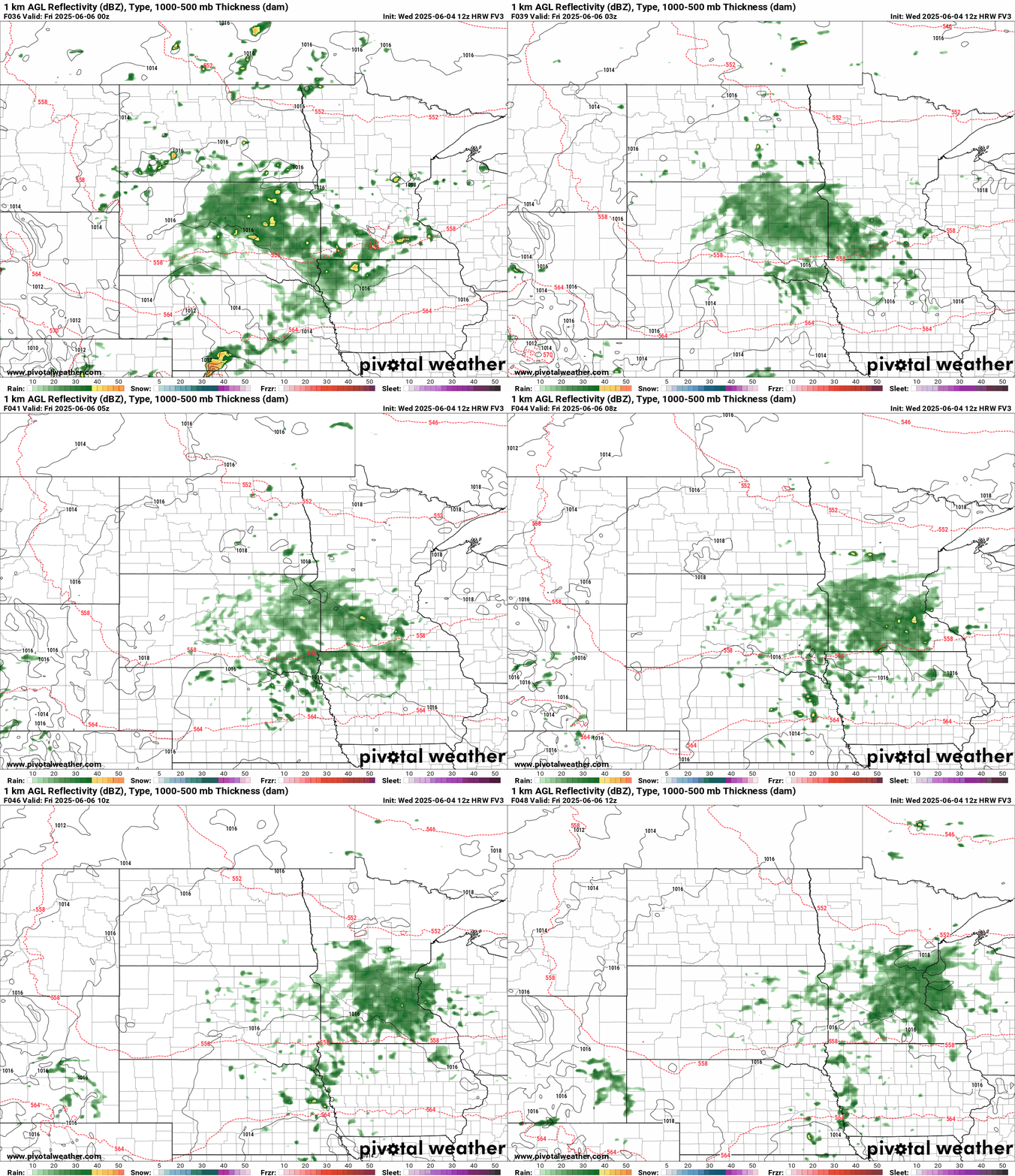
A second system may produce some rainfall Saturday night into Sunday morning.
Overall, rainfall through the weekend looks likely to range between one-half inch and 1 inch across much of Minnesota.
Here’s the European model’s artificial intelligence-enhanced rainfall output through the weekend:

Next week looks warmer again with highs in the 80s to 90s possible.
Stay tuned.

