
Stronger storms favor central and northern Minnesota Friday; air quality alert northwest
Spotty thundershowers possible in the Twin Cities later Friday evening

Go Deeper.
Create an account or log in to save stories.
Like this?
Thanks for liking this story! We have added it to a list of your favorite stories.


We’re watching a few thunderstorms and some wildfire smoke in the Weather Lab on this Friday.
A cool front has triggered scattered strong storms with heavy rainfall across much of central Minnesota Friday afternoon. A flash flood warning is in effect for Cass County including the Walker area until 5 p.m.
Here’s the bulletin from the National Weather Service Duluth office:
BULLETIN - EAS ACTIVATION REQUESTED
Flash Flood Warning National Weather Service Duluth MN
149 PM CDT Fri Jul 11 2025 The National Weather Service in Duluth has issued a
* Flash Flood Warning for... West Central Cass County in north central Minnesota...
* Until 500 PM CDT Friday.
* At 149 PM CDT Friday, Doppler radar indicated thunderstorms producing heavy rain across the warned area. Between 1 and 2 inches of rain have fallen. Additional rainfall amounts of 1 to 2 inches are possible in the warned area. Flash flooding is ongoing or expected to begin shortly.
HAZARD...Flash flooding caused by thunderstorms. SOURCE...Radar. IMPACT...Flash flooding of small creeks and streams, urban areas, highways, streets and underpasses as well as other poor drainage and low-lying areas.
* Some locations that will experience flash flooding include... Walker, Leech Lake and Whipholt.
PRECAUTIONARY/PREPAREDNESS ACTIONS... Turn around, don't drown when encountering flooded roads. Most flood deaths occur in vehicles.
The National Oceanic and Atmospheric Administration’s FV3 model shows the storms in central Minnesota and the chances for a few isolated cells to develop around the greater Twin Cities this evening.
Turn Up Your Support
MPR News helps you turn down the noise and build shared understanding. Turn up your support for this public resource and keep trusted journalism accessible to all.
The nine-hour forecast model loop below runs between 3 p.m. Friday and midnight Saturday.
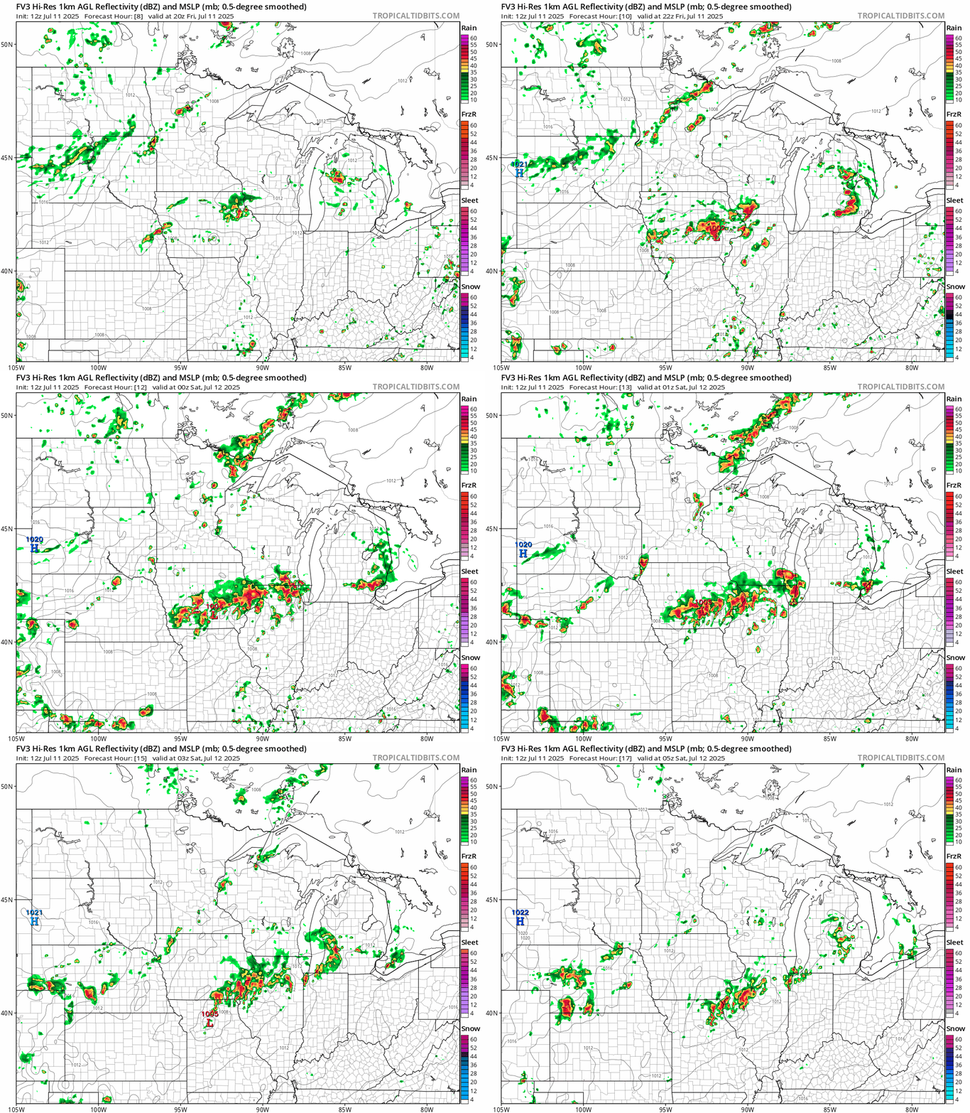
There is a marginal risk for severe storms in much of Minnesota but the setup is not great for widespread severe weather. Any storms that are able to approach the Twin Cities Friday evening are likely to stay below severe limits.
NOAA’s Storm Prediction Center does not expect to issue a watch zone Friday afternoon.
Air quality alert
Canadian wildfire smoke arrived as expected Friday in northwestern Minnesota. Air quality is very unhealthy in Fargo, N.D., and the Red River Valley.

An air quality alert continues until Friday evening in the northwest. (See the map at the top of the post.)
Here’s the Minnesota Pollution Control Agency alert:
The Minnesota Pollution Control Agency (MPCA) has issued an air quality alert for northwest and north central Minnesota. The alert takes effect 6 a.m. on Friday, July 11, and runs until 6 p.m. on Friday, July 11. The affected area includes Brainerd, Bemidji, East Grand Forks, Moorhead, International Falls, Roseau, and the Tribal Nations of Mille Lacs, Leech Lake, White Earth, and Red Lake.
Heavy ground-level smoke from wildfires in central Canada will move into northwest Minnesota early Friday morning behind a cold front. The first band of smoke will quickly move across northern Minnesota during the day Friday and reach northeast Minnesota by the evening. A second round of smoke will reach northwest Minnesota Friday evening. This round of smoke will be more widespread and may impact the northern half of the state on Saturday. The alert may need to be extended to cover the second round of smoke. Cleaner air will move into the state from the west on Sunday and air quality should improve beginning Sunday afternoon.
Fine particle levels are expected to reach the purple air quality index (AQI) category, a level considered very unhealthy for everyone, across northwest Minnesota. This area includes Bemidji, East Grand Forks, Roseau, and the Tribal Nations of Red Lake, Leech Lake, and White Earth. In the purple area, everyone should avoid prolonged or heavy exertion and stay indoors. Fine particle levels are expected to reach the red air quality index (AQI) category, a level considered unhealthy for everyone, across northwest and north central Minnesota. This area includes Brainerd, Moorhead, International Falls, and the Tribal Nations of Mille Lacs, Leech Lake, White Earth, and Red Lake. In the red area, sensitive groups should avoid prolonged or heavy exertion and limit time spent outdoors. Everyone should limit prolonged or heavy exertion and time spent outdoors.
The forecast is for more smoke Saturday in the north but better air quality by Sunday.
Here’s the latest forecast discussion from the Minnesota Pollution Control Agency:
Forecast discussion
Updated Fri, Jul 11, 2025
KEY MESSAGES: AQA in effect Friday for heavy smoke across northern MN. A second wave of widespread moderate to heavy smoke may impact the northern half of the state Saturday. Alert may need to be extended. DETAILED DISCUSSION: Wildfires across central Canada have intensified this week and have produced a large amount of smoke. A cold front will move across the state on Friday and very heavy smoke should move into northwest MN early Friday morning. This band of smoke should be narrow and fast moving and may reach northeast MN by the evening. An air quality alert will be in effect on Friday for northwest and north central MN. Air quality may reach the Purple (Very Unhealthy) category for several hours for northwest MN Friday. Air quality may reach the Red (Unhealthy) category for several hours across north central and west central MN. A second wave of moderate to heavy smoke is expected to arrive into the state Friday evening and may impact the northern half of the state on Saturday. The alert may need to be extended through Saturday to cover the second round of smoke. Cleaner air will move into the state from the west on Sunday and air quality should improve.

