
Hot and stormy Tuesday for much of Minnesota
Heat advisory for the Twin Cities Tuesday. Storms north and west could reach Twin Cities Tuesday evening.

Go Deeper.
Create an account or log in to save stories.
Like this?
Thanks for liking this story! We have added it to a list of your favorite stories.


It’s a clash of seasons across Minnesota Tuesday. A fall-like air mass in northern Minnesota will crash into a steamy summer heat wave in the south.

The result? A steamy to stormy Tuesday ahead.
Heat advisory for the Twin Cities
The southern half of Minnesota will feel like deep summer Tuesday. A sultry air mass with highs in the low 90s and dew points in the 70s will push heat index values to near 100 degrees Tuesday afternoon in the Twin Cities and southern Minnesota.
A heat advisory has been issued for the Twin Cities Tuesday between noon and 8 p.m.
Turn Up Your Support
MPR News helps you turn down the noise and build shared understanding. Turn up your support for this public resource and keep trusted journalism accessible to all.
URGENT - WEATHER MESSAGE National Weather Service Twin Cities/Chanhassen
MN 213 PM CDT Mon Jul 14 2025
Hennepin-Anoka-Ramsey-Washington-Carver-Scott-Dakota- Including the cities of Blaine, Stillwater, Hastings, St Paul, Chanhassen, Shakopee, Chaska, Minneapolis, and Victoria
213 PM CDT Mon Jul 14 2025
...HEAT ADVISORY IN EFFECT FROM NOON TO 8 PM CDT TUESDAY...
* WHAT...Heat index values up to 98 expected.
* WHERE...Anoka, Carver, Dakota, Hennepin, Ramsey, Scott, and Washington Counties.
* WHEN...From noon to 8 PM CDT Tuesday.
* IMPACTS...Hot temperatures and high humidity may cause heat illnesses.
Storm coverage increases Tuesday
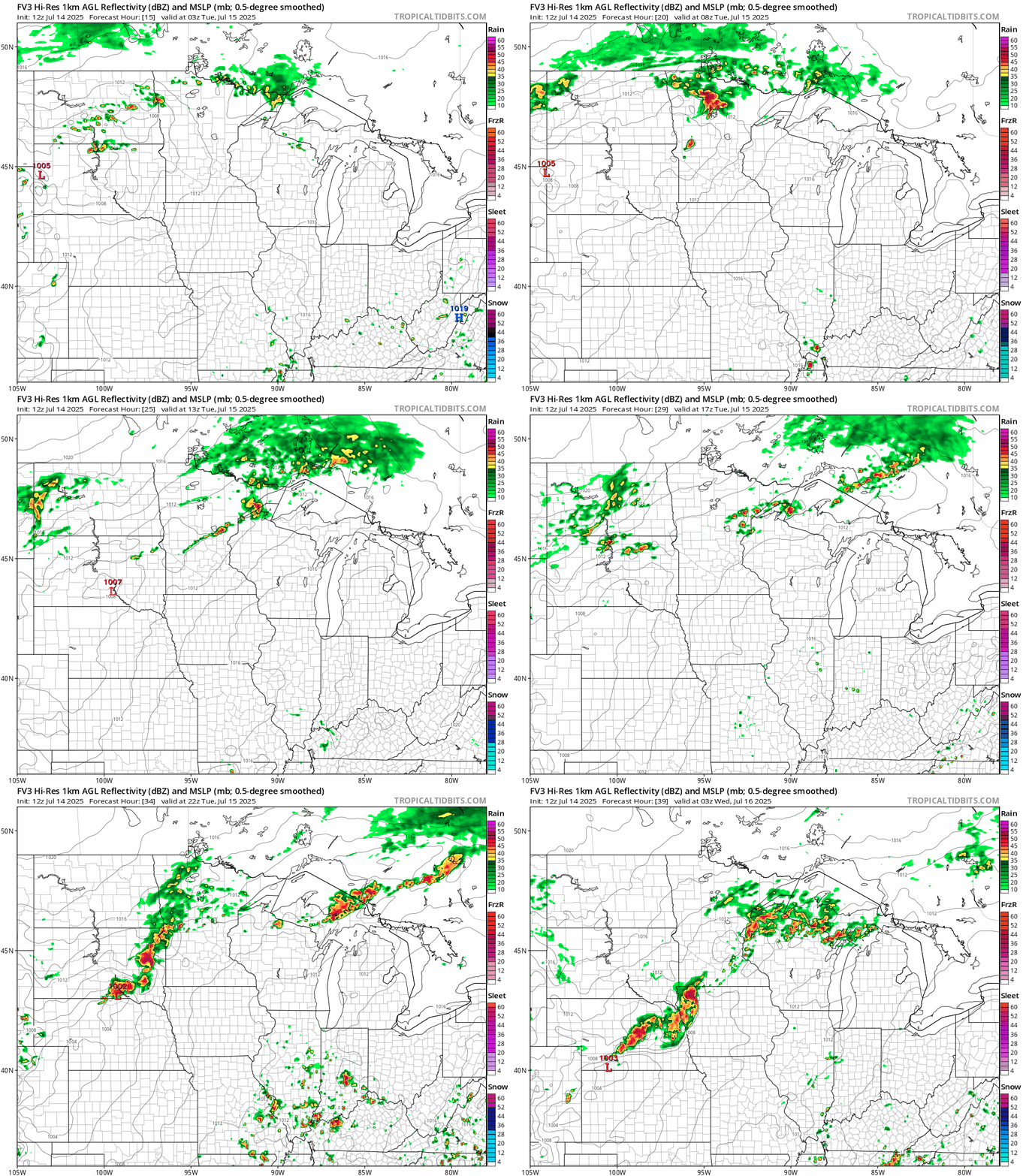
To the north, a frontal zone will spawn some nocturnal thunderstorms development overnight into Tuesday morning.
The storms will gradually develop further southward through the afternoon Tuesday. The best chances for storms in the Twin Cities arrives Tuesday evening after about 8 p.m. to 9 p.m.
NOAA’s FV3 model shows storms north early Tuesday and a possible (fading?) line of storms near the Twin Cities Tuesday evening. The forecast model loop below runs between 10 p.m. Wednesday and 10 p.m. Tuesday.
There is a slight risk for severe storms north of the Twin Cities Tuesday with a lower marginal risk zone across most of southern Minnesota. There’s also a slight risk for excessive rainfall north and west of the Twin Cities.
Air quality alert north Tuesday
The MPCA has extended the air quality alert for northern Minnesota until 11 p.m. Tuesday for lingering wildfire smoke in the north.

The Minnesota Pollution Control Agency (MPCA) has issued an air quality alert for east central, west central, north central, northwest, central, and northeast Minnesota. The alert takes effect 3 p.m. on Monday, July 14, and runs until 11 p.m. on Tuesday, July 15. The affected area includes Brainerd, Hinckley, Bemidji, East Grand Forks, Moorhead, International Falls, Two Harbors, Hibbing, Ely, Duluth, Roseau, and the Tribal Nations of Mille Lacs, Leech Lake, White Earth, Red Lake, Grand Portage, and Fond du Lac.
Light winds will allow existing wildfire smoke across northern Minnesota to linger into this evening and overnight. Concentrations are expected to be highest along and near the shores of Lake Superior. An additional round of heavy surface smoke from wildfires across southern Canada is expected to transport into northern Minnesota on Tuesday.
Fine particle levels are expected to reach the red air quality index (AQI) category, a level considered unhealthy for everyone, across northeast Minnesota. This area includes Two Harbors, Duluth, and the Tribal Nations of Grand Portage and Fond du Lac. In the red area, sensitive groups should avoid prolonged or heavy exertion and limit time spent outdoors. Everyone should limit prolonged or heavy exertion and time spent outdoors. Fine particle levels are expected to reach the orange air quality index (AQI) category, a level considered unhealthy for sensitive groups, across east central, west central, north central, northwest, central, and northeast Minnesota. This area includes Brainerd, Hinckley, Bemidji, East Grand Forks, Moorhead, International Falls, Hibbing, Ely, Roseau, and the Tribal Nations of Mille Lacs, Leech Lake, White Earth, and Red Lake. In the orange area, sensitive groups should limit prolonged or heavy exertion and time spent outdoors.

