
Heat advisory south; storms and flood risk north
Heavy rainfall favors northern Minnesota; scattered Twin Cities storms favor Wednesday

Go Deeper.
Create an account or log in to save stories.
Like this?
Thanks for liking this story! We have added it to a list of your favorite stories.


It’s a free sauna across southern Minnesota Tuesday.
Temperatures are pushing through the 80s toward the 90-degree mark across the south. Throw in dew points in the 70s to near 80 degrees and you’ve got an oppressive summer day. Heat index values will push the 100-degree mark Tuesday afternoon.

A heat advisory is in effect until 8 p.m. for most of southern Minnesota, including the greater Twin Cities area.
Including the cities of Chaska, Stillwater, Chanhassen, Willmar, Faribault, New Ulm, Benson, Mankato, Gaylord, Minneapolis, Hastings, Madison, Blaine, St Paul, Hutchinson, Waseca, Montevideo, Shakopee, Redwood Falls, Monticello, Fairmont, St James, Victoria, Le Sueur, Litchfield, Granite Falls, St Peter, and Olivia
302 AM CDT Tue Jul 22 2025
...HEAT ADVISORY IN EFFECT FROM 1 PM THIS AFTERNOON TO 8 PM CDT THIS EVENING...
* WHAT...Heat index values in the upper 90s to low 100s expected.
* WHERE...Portions of central, east central, south central, southwest, and west central Minnesota.
* WHEN...From 1 PM this afternoon to 8 PM CDT this evening.
* IMPACTS...Hot temperatures and high humidity may cause heat illnesses.
Storms north
The most favored storm parameters favor central and northern Minnesota through Tuesday night.
Turn Up Your Support
MPR News helps you turn down the noise and build shared understanding. Turn up your support for this public resource and keep trusted journalism accessible to all.

Capping in the south may limit overall storm coverage for the Twin Cities and southern Minnesota until later Tuesday evening and especially Wednesday later afternoon and evening.
Forecast model solutions vary widely for storm coverage across southern Minnesota into Wednesday.
The National Oceanic and Atmospheric Administration’s Rapid Refresh Forecast System model seems to have a reasonable outcome with storms in the north and a chance for a few cells after about 10 p.m. Tuesday for the Twin Cities. A better chance for scattered storms in the Twin Cities and southern Minnesota arrives Wednesday later afternoon and evening.
The forecast model loop below runs between 4 p.m. Tuesday and 10 p.m. Wednesday.
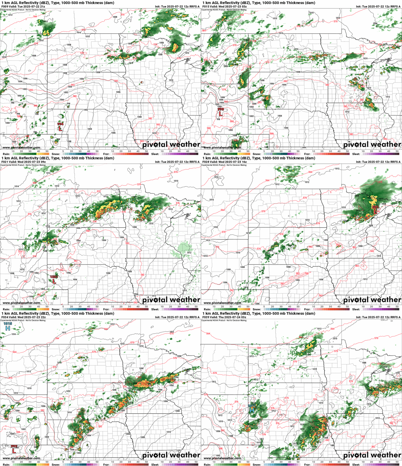
The biggest threat for severe storms and heavy rainfall favors the northern half of Minnesota through Tuesday night.

A flood watch is in effect for most of northeastern Minnesota.
Including the cities of Two Harbors, Hill City, Bigfork, Pine River, Walker, Ely, Silver Bay, Brainerd, Grand Rapids, Hibbing, Isabella, and Grand Marais
131 PM CDT Tue Jul 22 2025
...FLOOD WATCH REMAINS IN EFFECT FROM 7 PM CDT THIS EVENING THROUGH THURSDAY MORNING...
* WHAT...Flash flooding caused by excessive rainfall is possible.
* WHERE...In Minnesota, Crow Wing, northern Aitkin, Itasca, Cass, Cook, Lake and central and northern St. Louis Counties. This includes the Tribal Lands of the Grand Portage Reservation, the Mille Lacs Band, Big Sandy Lake area and the Bois Forte Band, Lake Vermilion, Nett Lake and, Deer Creek areas. Other locations including Voyageurs National Park. The entire Boundary Waters is also included.
* WHEN...From 7 PM CDT this evening through early Thursday morning.
* IMPACTS...Excessive runoff may result in flooding of rivers, creeks, streams, and other low-lying and flood-prone locations.
* ADDITIONAL DETAILS... - Multiple rounds of heavy rainfall are forecast this evening through late Wednesday night. This heavy rainfall may fall on top of already saturated soils from other recent heavy rainfall and lead to excessive runoff. Flash flooding is possible. - Flood safety information can be found at www.weather.gov/safety/flood.
Stay tuned.

