
Flash flood risk expanding for much of Minnesota including the Twin Cities
Flooding already occurring in northern and central Minnesota. Heavy rainfall in Twin Cities and the south expanding through Wednesday evening.

Go Deeper.
Create an account or log in to save stories.
Like this?
Thanks for liking this story! We have added it to a list of your favorite stories.


Our Land of 10,000 Lakes has a whole lot more temporary lakes on this late July Wednesday.
Torrential rainfall rates have dumped 2 to 5 inches of rain across much of central and northern Minnesota so far — and heavy rainfall is causing multiple locations to flood. Check out this scene in Ely Wednesday.
A cold front is crawling southward Wednesday. Storms are bubbling up and feeding on rich tropical moisture with dew points in the 70s.
That’s producing heavy rainfall. A flood watch remains in effect for all of northern Minnesota into Thursday morning including the cities of Brainerd, Silver Bay, Grand Rapids, Two Harbors, Hill City, Bigfork, Walker, Ely, Isabella, Hibbing, Pine River, and Grand Marais .
Turn Up Your Support
MPR News helps you turn down the noise and build shared understanding. Turn up your support for this public resource and keep trusted journalism accessible to all.
515 AM CDT Wed Jul 23 2025
...FLOOD WATCH REMAINS IN EFFECT THROUGH THURSDAY MORNING...
* WHAT...Flooding caused by excessive rainfall continues to be possible.
* WHERE...In Minnesota, Crow Wing, northern Aitkin, Itasca, Cass, Cook, Lake and central and northern St. Louis Counties. This includes the Tribal Lands of the Grand Portage Reservation, the Mille Lacs Band, Big Sandy Lake area and the Bois Forte Band, Lake Vermilion, Nett Lake and, Deer Creek areas. Other locations including Voyageurs National Park. The entire Boundary Waters is also included.
* WHEN...Through Thursday morning.
* IMPACTS...Excessive runoff may result in flooding of rivers, creeks, streams, and other low-lying and flood-prone locations. * ADDITIONAL DETAILS... - Multiple rounds of heavy rainfall are forecast through late Wednesday night. This heavy rainfall may fall on top of already saturated soils from other recent heavy rainfall and lead to excessive runoff. Flash flooding is possible.
Twin Cities and southern Minnesota flood risk
Numerous thunderstorms with heavy rain will increase through Wednesday evening the Twin Cities and southern Minnesota. As of this post a flash flood warning is in effect for the northwest Twin Cities area.
BULLETIN - EAS ACTIVATION REQUESTED Flash Flood Warning National Weather Service Twin Cities/Chanhassen
MN 115 PM CDT Wed Jul 23 2025
The National Weather Service in the Twin Cities has issued a
* Flash Flood Warning for... Central Anoka County in east central Minnesota... Northwest Hennepin and Northeast Hennepin County in east central Minnesota...
* Until 215 PM CDT.
* At 115 PM CDT, Doppler radar indicated thunderstorms producing heavy rain over Champlin, or 15 miles north of Minneapolis, moving northeast at 50 mph. Between 1 and 2 inches of rain have fallen. The expected rainfall rate is 1 to 2 inches in 1 hour. Additional rainfall amounts of 1 to 3 inches are possible in the warned area. Flash flooding is ongoing or expected to begin shortly. HAZARD...Flash flooding caused by thunderstorms.
SOURCE...Radar indicated. IMPACT...Flash flooding of small creeks and streams, urban areas, highways, streets and underpasses as well as other poor drainage and low-lying areas. * Some locations that will experience flash flooding include... Brooklyn Park, Maple Grove, Coon Rapids, Blaine, Andover, Fridley, Champlin, Anoka, Ham Lake, Corcoran, Osseo and Blaine Airport. PRECAUTIONARY/PREPAREDNESS ACTIONS... Turn around, don't drown when encountering flooded roads. Most flood deaths occur in vehicles.
I expect we could see flash flood warnings increase through much of the Twin Cities Wednesday afternoon and evening. You can get updated warnings here.
NOAA’s RRFS model seems to have a good handle on likely storm coverage along the cold front sagging south through the Twin Cities and southern Minnesota into Wednesday evening. The RRFS forecast model loop below runs between 4-10 p.m. Wednesday.
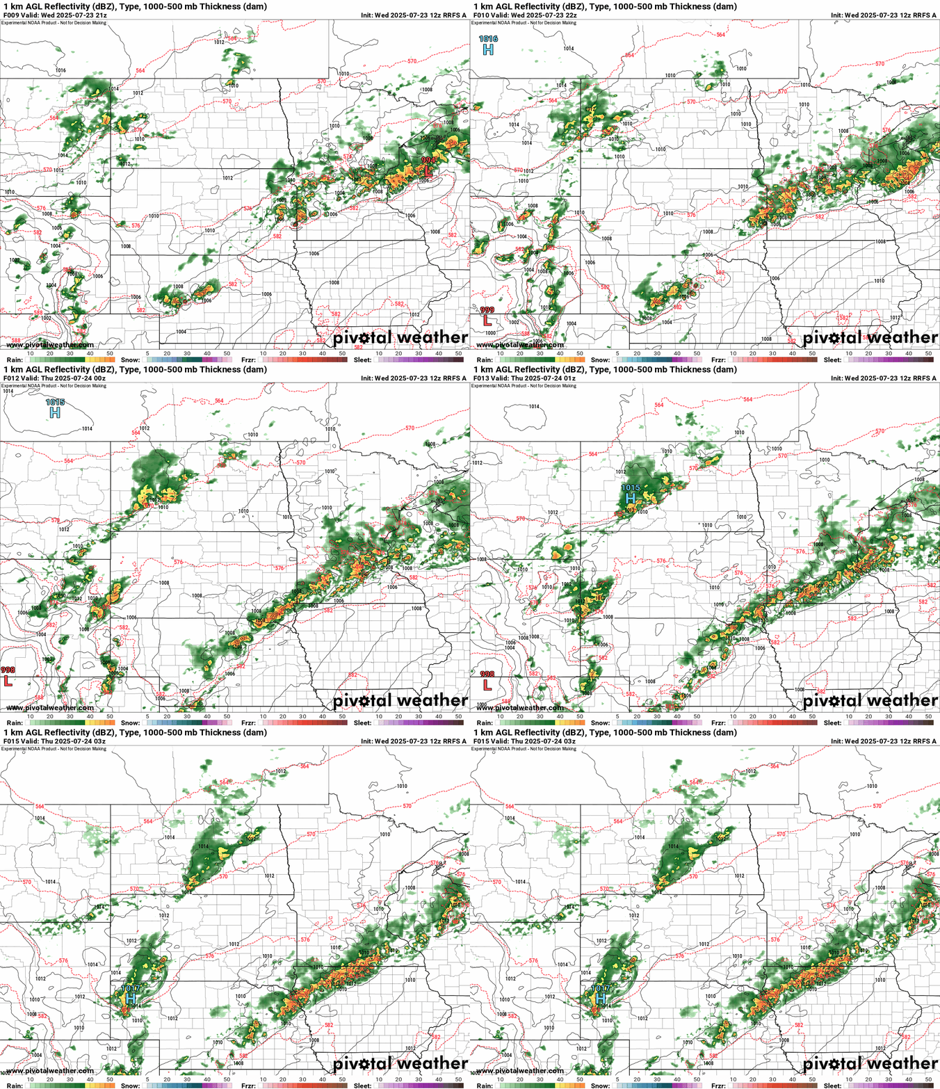
The heat advisory has been cancelled for the Twin Cities area to due widespread storm coverage limiting temperatures, but the advisory continues for southeast Minnesota.
Expect possible severe weather and flooding through Wednesday evening!

