
Derecho-level winds slam northwest Iowa; severe storms clip Twin Cities
Wind gust to 99 mph and damage in parts of Iowa.
Go Deeper.
Create an account or log in to save stories.
Like this?
Thanks for liking this story! We have added it to a list of your favorite stories.


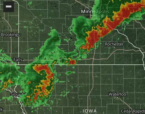
Severe storms raked parts of Minnesota with the heaviest storms in Iowa.
The Twin Cities saw heavy downpours, lots of lightning and thunder, and gusty winds over 60 mph locally. Scattered tree damage and power outages are reported.
Here are some select storm reports.
2 SSW Hutchinson [Mcleod Co, MN] AWOS reports Tstm Wnd Gst of M60 MPH at 28 Jul, 9:09 PM CDT -- Hutchinson airport.
Mayer [Carver Co, MN] Trained Spotter reports Tstm Wnd Dmg at 28 Jul, 9:29 PM CDT -- 12 inch diameter tree snapped at the base.
1 W Dellwood [Ramsey Co, MN] Amateur Radio reports Tstm Wnd Dmg at 28 Jul, 9:40 PM CDT -- Two trees down on the north side of White Bear Lake.
3 ENE Richfield [Hennepin Co, MN] ASOS reports Tstm Wnd Gst of M60 MPH at 28 Jul, 9:47 PM CDT -- Measured at MSP Airport.
1 W South St. Paul [Dakota Co, MN] Amateur Radio reports Tstm Wnd Dmg at 28 Jul, 9:50 PM CDT -- Tree down on Southview Blvd near Hwy 52.
3 NNW New Prague [Scott Co, MN] Mesonet reports Tstm Wnd Gst of E61 MPH at 28 Jul, 9:56 PM CDT -- Measured by Scott County mesonet.
The well advertised derecho is still to be determined depending on path length for the storms. But derecho level winds slammed South Dakota and northwest Iowa.
Here are some select wind and damage reports from South Dakota and northwest Iowa. A wind gust to 99 mph was recorded by a personal weather station near Sioux Center, Iowa at 9:43 p.m. Monday.
1 NW Wagner [Charles Mix Co, SD] Mesonet reports Tstm Wnd Gst of M72 MPH at 28 Jul, 7:17 PM CDT -- Personal weather station.
5 W Sioux Falls [Minnehaha Co, SD] Public reports Tstm Wnd Dmg at 28 Jul, 8:49 PM CDT -- Large tree limbs broken down by winds estimated at 65 mph.
6 SSE Centerville [Clay Co, SD] Mesonet reports Tstm Wnd Gst of M77 MPH at 28 Jul, 8:55 PM CDT -- Mesonet station BFMS2 Beresford 7 WSW.
2 NW Orange City [Sioux Co, IA] Public reports Tstm Wnd Gst of M92 MPH at 28 Jul, 9:41 PM CDT -- Personal weather station.
4 SSE Rock Rapids [Lyon Co, IA] Mesonet reports Tstm Wnd Gst of M79 MPH at 28 Jul, 9:52 PM CDT -- Personal weather station.
Primghar [O'Brien Co, IA] Emergency Mngr reports Tstm Wnd Dmg at 28 Jul, 10:08 PM CDT -- Highway 59 across the entire town is closed due to so many trees knocked down onto the road by thunderstorm wind gusts.
Orange City [Sioux Co, IA] Emergency Mngr reports Tstm Wnd Dmg at 28 Jul, 9:34 PM CDT -- Trees knocked down by thunderstorm wind gusts.
2 WSW Sioux Center [Sioux Co, IA] Mesonet reports Tstm Wnd Gst of M99 MPH at 28 Jul, 9:39 PM CDT -- Personal weather station.
Our weather tuns quieter and cooler the rest of the week with highs in the 70s by Wednesday.

.An air quality alert is up for the northern half of Minnesota Tuesday and Wednesday.

The Minnesota Pollution Control Agency (MPCA) has issued an air quality alert for central, east central, west central, north central, northwest, and northeast Minnesota. The alert takes effect 6 a.m. on Tuesday, July 29, and runs until 11 p.m. on Wednesday, July 30. The affected area includes Brainerd, Alexandria, Hinckley, St. Cloud, Ortonville, Bemidji, East Grand Forks, Moorhead, International Falls, Two Harbors, Hibbing, Ely, Duluth, Roseau, and the Tribal Nations of Mille Lacs, Leech Lake, White Earth, Red Lake, Grand Portage, and Fond du Lac.
Northwesterly winds will transport heavy surface smoke from wildfires across Manitoba and Saskatchewan into northern Minnesota, beginning Tuesday morning. Smoke will spread south into central Minnesota through the day Tuesday and may continue into southern Minnesota overnight Tuesday into Wednesday. Therefore, the air quality alert may need to be expanded further south into southern Minnesota. High pressure will blanket much of the region from Wednesday through Friday, which will result in light winds and poor dispersion of smoke. Therefore, the alert may need to be extended beyond Wednesday.
Fine particle levels are expected to reach the red air quality index (AQI) category, a level considered unhealthy for everyone, across north central, northwest, northeast, and east central Minnesota. This area includes Bemidji, East Grand Forks, International Falls, Two Harbors, Hibbing, Ely, Duluth, Roseau, and the Tribal Nations of Leech Lake, White Earth, Red Lake, Grand Portage, Mille Lacs, and Fond du Lac. In the red area, sensitive groups should avoid prolonged or heavy exertion and limit time spent outdoors. Everyone should limit prolonged or heavy exertion and time spent outdoors.
Fine particle levels are expected to reach the orange AQI category, a level considered unhealthy for sensitive groups, across central, east central, west central, north central, and northwest Minnesota. This area includes Brainerd, Alexandria, Hinckley, St. Cloud, Ortonville, Moorhead, and the Tribal Nations of Mille Lacs and White Earth. In the orange area, sensitive groups should limit prolonged or heavy exertion and time spent outdoors.
Turn Up Your Support
MPR News helps you turn down the noise and build shared understanding. Turn up your support for this public resource and keep trusted journalism accessible to all.

