
Derecho slammed Iowa Monday night; drier forecast ahead
Storms raked Twin Cities, southern Minnesota but 80 mph winds stayed in Iowa, South Dakota
Go Deeper.
Create an account or log in to save stories.
Like this?
Thanks for liking this story! We have added it to a list of your favorite stories.


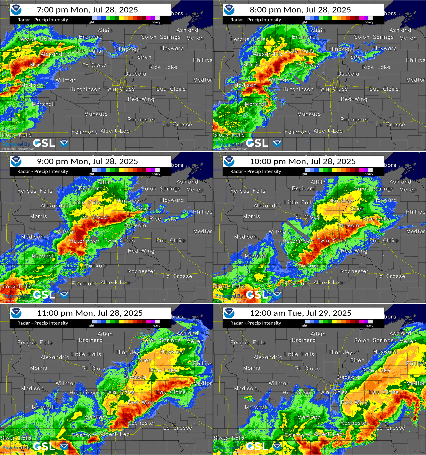
Our stormy summer storms much of southern Minnesota once again.
We’re still cleaning up Here are some of the peak wind gusts in Minnesota last night.
Rochester, Stewartville, 76 mph
Kasson, 74 mph
Lake City, 68 mph
Shakopee, 65 mph
Minneapolis-St. Paul International Airport, 60 mph
Thankfully, the storms did not produce widespread derecho-level wind gusts in the Twin Cities area last night.
The heaviest storms tracked south of Minnesota across eastern South Dakota and Iowa. It looks like the damaging wind gusts were long enough to reach derecho criteria in South Dakota and Iowa Monday night.
Turn Up Your Support
MPR News helps you turn down the noise and build shared understanding. Turn up your support for this public resource and keep trusted journalism accessible to all.
Here’s what’s needed for a storm to meet derecho criteria according to the National Oceanic and Atmospheric Administration’s Storm Prediction Center:
By definition, if the swath of wind damage extends at least 250 miles (about 400 kilometers) long, includes wind gusts of at least 58 mph (93 km/h) along its length, with several, well-separated 75 mph (121 km/h) or greater gusts, and originates from an MCS that moves faster than the mean wind speed (thus being primarily cold pool driven), the event may be classified as a derecho.
Multiple wind gusts over 80 mph were recorded from eastern South Dakota through northern Iowa Monday night, and it appears the wind damage path tracked for more than 250 miles.
The peak gust appears to be an incredible 99 mph in Sioux Center, Iowa. I’m seeing National Weather Service reports of at least 11 gusts between 75 and 99 mph along the storm’s path.

Air quality alert
Another smudge of Canadian wildfire smoke is drifting south across Minnesota. Air quality is still good in the south, but deteriorating in the north Tuesday afternoon.
Our latest air quality alert covers about the northern half of Minnesota through Wednesday.
The alert may be expanded to include southern Minnesota Wednesday. Here’s the latest forecast discussion from the Minnesota Pollution Control Agency:
Updated Tue, Jul 29, 2025
KEY MESSAGES: 1) Air Quality Alert has been issued for northern and central Minnesota. 2.) Heavy surface smoke may spread to southern Minnesota Tuesday night and Wednesday. 3.) Smoke may produce poor air quality statewide through Friday. DETAILED DISCUSSION: Upper level winds will steer wildfire smoke from central Saskatchewan and Manitoba southeast towards and/or into Minnesota through today (Tuesday), and surface high pressure will help keep the smoke at the surface. Smoke will continue to drift south Tuesday night into Wednesday, and the air quality alert may need to be expanded to include southern Minnesota on Wednesday. Surface high pressure will blanket the region through Friday, and result in light winds and poor dispersion. Therefore, smoke may remain over the state until Friday when winds finally switch from the south. Ground-level ozone production may increase due to the presence of wildfire smoke in a drier, albeit cooler, environment, through Friday as well.
Cooler and drier weather ahead
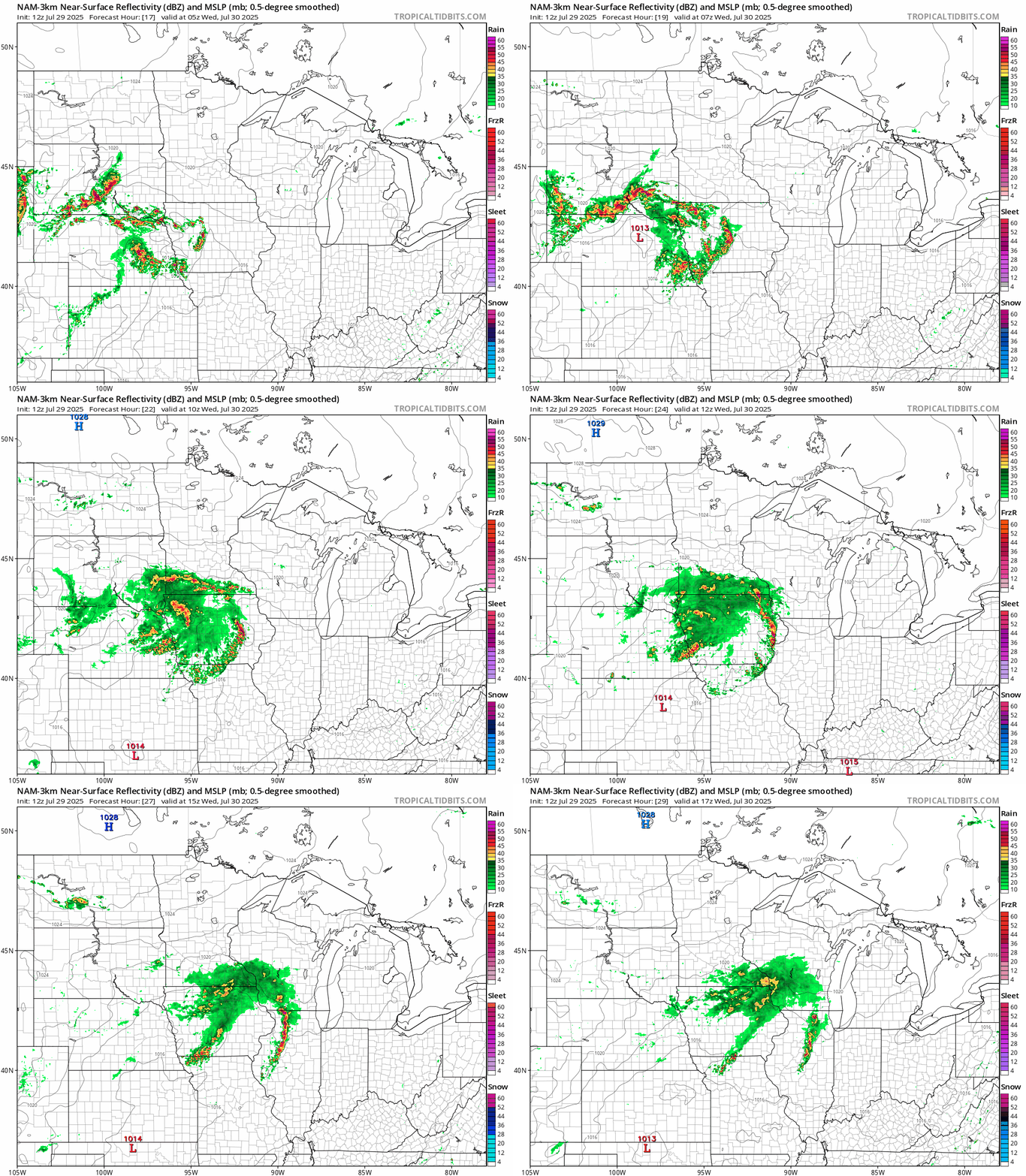
More rain and thunder are ahead for southern Minnesota late Tuesday night into Wednesday., but it looks like most of that system will stay south of the Twin Cities and away from the worst flooded areas like Morris in Stevens County.
On the map below, NOAA’s NAM 3 km model shows the trend between midnight and noon Wednesday with showers and a few embedded thunderstorms favoring the Interstate 90 corridor in the south.
Temperatures will feel increasingly pleasant this week with highs in the 70s!

Enjoy our respite form heat, humidity, and storms.

