
Scattered storms west; air quality alert for northeast Minnesota
A few scattered thunderstorms favor western Minnesota through the overnight hours

Go Deeper.
Create an account or log in to save stories.
Like this?
Thanks for liking this story! We have added it to a list of your favorite stories.


It’s a mixed weather bag around Minnesota into Wednesday. We’ve got summery temperatures, some wildfire smoke and a few scattered thunderstorms in the short range forecast.
Scattered storms west
A weak low pressure wave is sparking scattered thunderstorms in western Minnesota that will move east through the night into Wednesday morning. But the cells will run into more stable air as they cross Minnesota overnight. Most models fade the storms by the time they can reach the Twin Cities and eastern Minnesota early Wednesday morning.
National Oceanic and Atmospheric Administration’s HRRR model shows the fading storm trends between 4 p.m. Tuesday and 6 a.m. Wednesday.
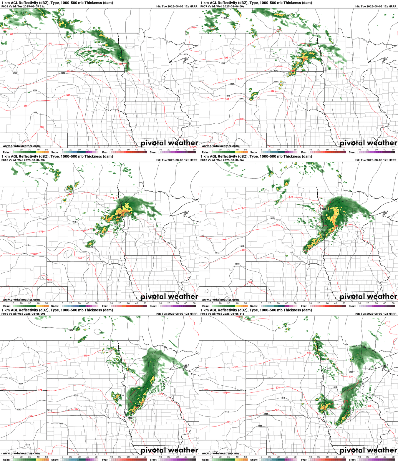
There is a marginal or low risk for a couple severe cells for western Minnesota overnight into Wednesday morning.
Turn Up Your Support
MPR News helps you turn down the noise and build shared understanding. Turn up your support for this public resource and keep trusted journalism accessible to all.
Temperatures Wednesday will remain on the summery side with 80s and just a slight chance for isolated thunderstorms. Temperatures this week will peak in the steamy low 90s on Friday across the south.

Air quality alert
An air quality alert remains in effect until noon Wednesday for northeast Minnesota. (map at top)
Air quality is good to moderate across most of Minnesota as of Tuesday afternoon. But there are some unhealthy readings in the northeast.

Air quality should improve as we move through the week thanks to southerly winds. But another smoke wave may arrive behind the next cold front this weekend. Some of the Canadian wildfire zones will get some rain this week. We’ll have to see how thick the smoke layers are that eventually blow in from the northwest this weekend.
Here’s the latest forecast discussion from MPCA.
Updated Tue, Aug 5, 2025
KEY MESSAGES: 1.) An air quality alert is in effect for northeastern Minnesota from today (Tuesday) through noon Wednesday. 2.) Another round of heavy surface smoke may impact Minnesota this weekend. DETAILED DISCUSSION: Areas of heavy smoke are expected to rotate from Wisconsin and Michigan northwestward into northeastern Minnesota into Wednesday, and an air quality alert is in effect until noon Wednesday. Moderate levels of smoke may linger into Wednesday evening. Southerly winds will continue to improve air quality slowly but surely across the rest of the state, but Yellow (moderate) AQI is forecast. While a warming trend is expected towards the end of the week, dewpoints will be on the rise as well which will limit ground-level ozone production. Looking further ahead, a cold front will move through the state this weekend, and heavy surface Canadian wildfire smoke may follow. The largest source of uncertainty at this time revolves around the potential for substantial rain across some of the Canadian wildfires this week, which would limit the amount of smoke. Stay tuned for updates.
MPCA tells me we’re up to 33 air quality alerts issued in Minnesota so far this year. That’s just 8 behind the record of 41 set in 2023. Unfortunately we have a chance of exceeding that record this year if alerts keep coming at the same pace.
Stay tuned.

