
Air quality alert until 9 a.m. Tuesday; spotty storms north overnight
Thickest wildfire smoke crosses Minnesota Monday night; better air quality ahead

Go Deeper.
Create an account or log in to save stories.
Like this?
Thanks for liking this story! We have added it to a list of your favorite stories.


Our latest wave of wildfire smoke is passing through Minnesota.
The thickest part of this smoky plume moves through Monday night into early Tuesday. You can see the nastier red (unhealthy) air quality readings covering most of Minnesota and sliding east as of early Monday evening.

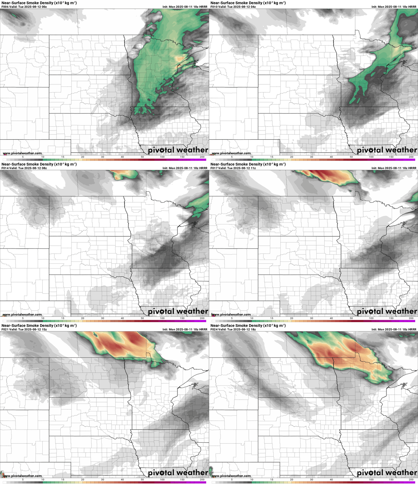
The National Oceanic and Atmospheric Administration’s High-Resolution Rapid Refresh near-surface smoke output shoes the trend into midday Tuesday. Air quality will improve in the south but another wave of smoke will sag into northern Minnesota.
Our latest air quality alert is in effect until 9 a.m. Tuesday. (See the map at the top of the post). Here are the details:
Turn Up Your Support
MPR News helps you turn down the noise and build shared understanding. Turn up your support for this public resource and keep trusted journalism accessible to all.
The Minnesota Pollution Control Agency (MPCA) has issued an air quality alert for all of Minnesota. The alert takes effect 9 a.m. on Sunday, Aug. 10, and runs until 9 a.m. on Tuesday, Aug. 12. The affected area includes the Twin Cities metro area, Brainerd, Alexandria, Albert Lea, Marshall, Worthington, Rochester, Hinckley, St. Cloud, Winona, Ortonville, Mankato, Bemidji, East Grand Forks, Moorhead, International Falls, Two Harbors, Hibbing, Ely, Duluth, Roseau, and the Tribal Nations of Upper Sioux, Mille Lacs, Prairie Island, Leech Lake, White Earth, Red Lake, Grand Portage, and Fond du Lac.
Heavy surface smoke from many wildfires across central Saskatchewan and Manitoba will wrap around the backside of an area of low pressure this weekend as the low moves east across south central Canada. Poor air quality will most likely impact western Minnesota beginning Sunday morning, and then expand further east through the evening. Heavy smoke should then disperse from west to east across the state from Monday into Tuesday morning.
Fine particle levels are expected to reach the red air quality index (AQI) category, a level considered unhealthy for everyone, across central, east central, west central, north central, northwest, and northeast Minnesota. This area includes Brainerd, Alexandria, Hinckley, St. Cloud, Ortonville, Bemidji, East Grand Forks, Moorhead, International Falls, Two Harbors, Hibbing, Ely, Duluth, Roseau, and the Tribal Nations of Mille Lacs, Leech Lake, White Earth, Red Lake, Grand Portage, and Fond du Lac. In the red area, sensitive groups should avoid prolonged or heavy exertion and limit time spent outdoors. Everyone should limit prolonged or heavy exertion and time spent outdoors.
Fine particle levels are expected to reach the orange AQI category, a level considered unhealthy for sensitive groups, across west central, east central, south central, southwest, southeast, and central Minnesota. This area includes the Twin Cities metro area, Albert Lea, Marshall, Worthington, Rochester, Winona, Mankato, and the Tribal Nations of Upper Sioux and Prairie Island. In the orange area, sensitive groups should limit prolonged or heavy exertion and time spent outdoors.
Southerly winds this week will bring better air quality to southern and western Minnesota moving forward. But some smoke will linger in the north this week.

Here’s the latest forecast discussion from Minnesota Pollution Control Agency:
Updated Mon, Aug 11, 2025
KEY MESSAGES: 1) Heavy surface smoke will impact Minnesota Monday, and an air quality alert remains in effect through 9am Tuesday. 2) Smoke will move east and exit the state Tuesday morning, but a new band of smoke will move into northern MN. 3) AQA will be extended for northern MN through Wednesday. DETAILED DISCUSSION: Heavy surface smoke will impact the state Monday. The heaviest smoke will be across the northern half of the state, where air quality in the Red (Unhealthy) AQI category is expected. Across southern Minnesota, air quality in the Orange (Unhealthy for Sensitive Groups) category is expected. Southwest MN may see very heavy smoke for a brief period in the afternoon before cleaner air moves into that region in the evening. Smoke will reach the Twin Cities, southeast MN, and the Arrowhead region later in the day and these regions will experience the heaviest smoke late in the evening through the overnight. A fairly progressive weather pattern will prevent this smoke from lingering across the state for too long. Therefore, heavy smoke should gradually clear from west to east through Monday and into Tuesday morning. However, additional surface smoke will move into northern Minnesota on Tuesday due to northwest transport winds from Canada into Minnesota. This smoke won't be as heavy, but will likely still create air quality conditions in the Orange category across northern Minnesota on Tuesday and Wednesday. The AQA will likely be extended for northern MN through Wednesday. This band of smoke will be narrow and remain confined to the northern one-third of the state. Air quality across central and southern MN will gradually improve Tuesday through Thursday.
Spotty storms overnight
A line of thunderstorms will cross mainly northern Minnesota overnight into early Tuesday. NOAA’s High-Resolution Rapid Refresh model shows a narrow line of mostly garden-variety thunderstorms sliding southeast overnight.
There’s a slight chance some may reach the Twin Cities very early Tuesday.
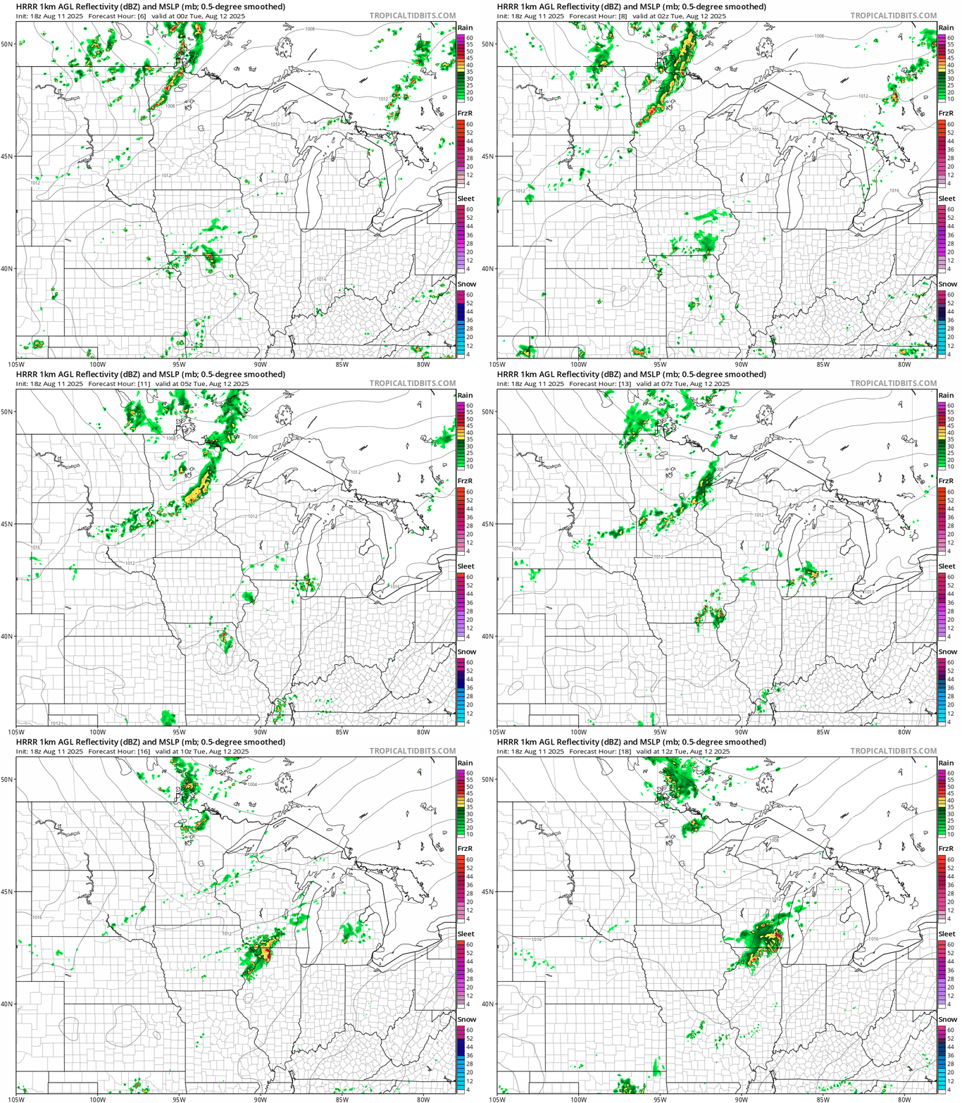
Severe weather risk is low with just a marginal risk for a severe storms. A few cells may produce gusty winds and some hail overnight.
Steamy weekend ahead
Highs this week will run in the low 80s in the south with mostly 70s north.

But by Friday another steamy air mass blows in with dew points climbing into the 70s again and highs into the upper 80s.

We’ll run about a 30 percent chance for spotty storms this weekend.
Get ready for another steamy late summer weekend in Minnesota.

