
Could the record ‘warm blob’ Pacific Ocean heat wave bring a rigorous winter to Minnesota?
Record warm ocean temperatures in the North Pacific may affect winter weather patterns.

Go Deeper.
Create an account or log in to save stories.
Like this?
Thanks for liking this story! We have added it to a list of your favorite stories.


They call it the “warm blob.”
A giant pool of record warm ocean water in the north Pacific Ocean developed this summer. Water temperatures averages 68 degrees across the North Pacific basin in August. That’s a degree warmer than the previous record set 12 years ago. Reliable records of North Pacific Ocean temperatures date back to 1854.
The giant blob of record warm water is also the 4th largest on record since 1982. It runs from Alaska to Hawaii and from Asia to California!
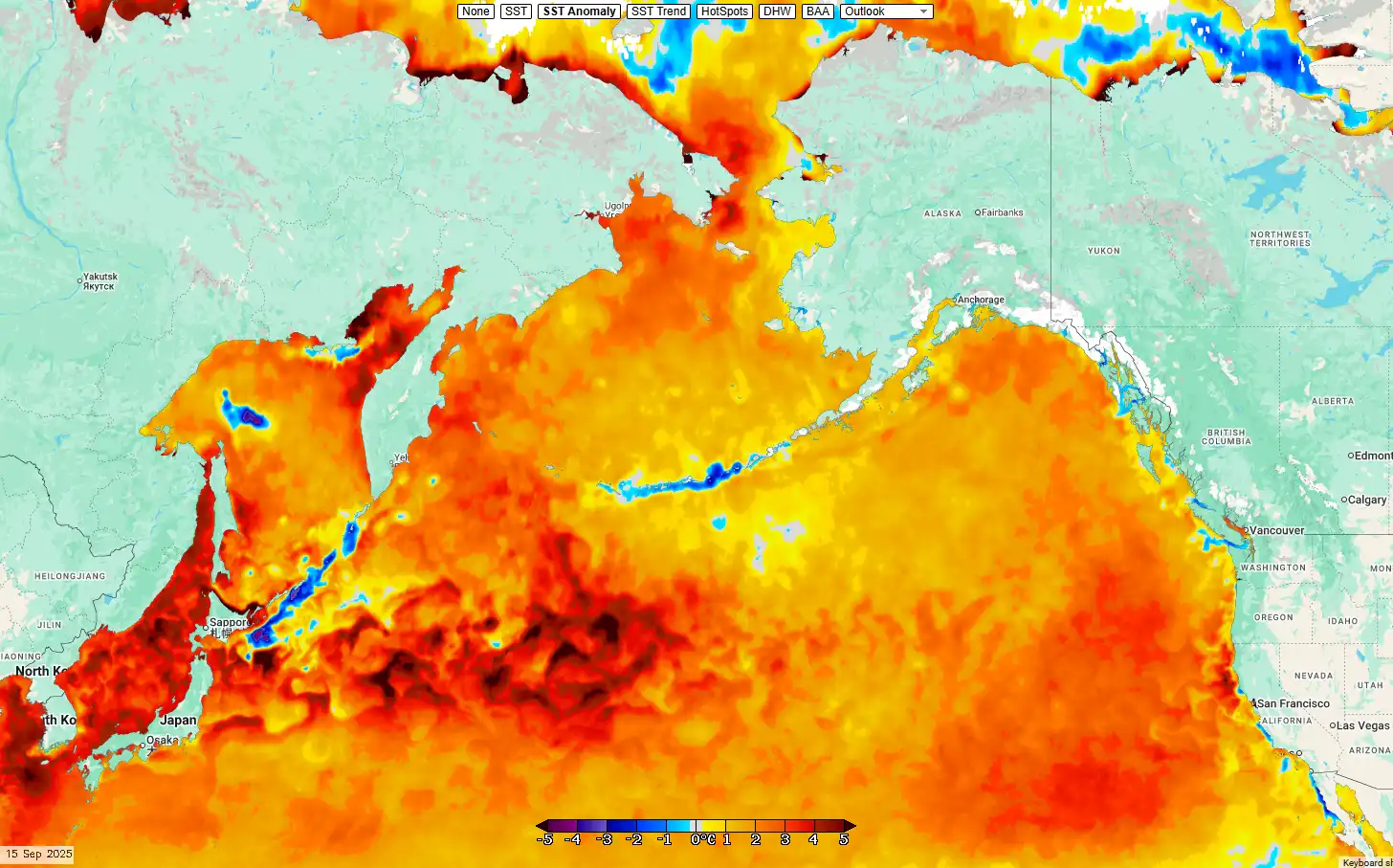
These marine heatwaves affects marine ecosystems. But the biggest impacts for us here in Minnesota may be jet stream pattern for this upcoming winter.
Turn Up Your Support
MPR News helps you turn down the noise and build shared understanding. Turn up your support for this public resource and keep trusted journalism accessible to all.
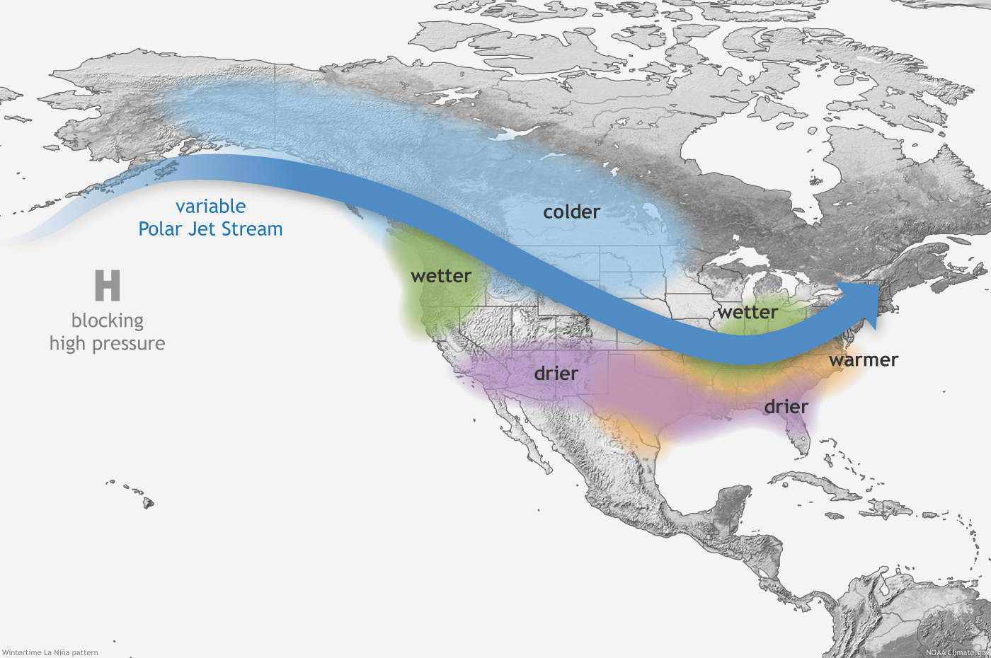
The giant warm blob can shift jet stream patterns across North America. Areas in the southwest U.S. can be warmer and drier.
But further east the jet stream flow can dislodge the Polar Vortex more frequently in the winter season and cause more frequent bitter Arctic outbreaks in the Midwest and eastern U.S. The prevailing jet stream patterns can mimic La Niña winters.
Minnesota’s winter of 2013-14
The previous record warm event in the North Pacific preceded the 2013-14 winter. Minnesota endured multiple bitter subzero Polar Vortex outbreaks that winter.
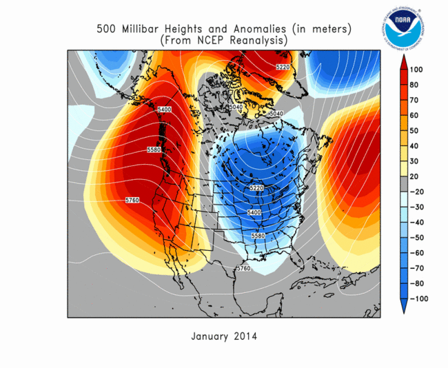
The Twin Cities recorded 53 nights of subzero temperatures that winter. International Falls suffered through 92 night of subzero temperatures!
And a whopping 70 inches of snow fell in the Twin Cities in the winter of 2013-14, with snowfall totals over 100 inches on the north.

The Minnesota State Climate Office summary of the winter of 2013-14 highlights the bitter snowy memories of that brutal winter.
Winter Recap of 2013-14
The Polar Vortex: January 2014
Courtesy: National Climate Data CenterThe 2013-14 winter was noteworthy on many counts. The 53 nights of at or below zero temperatures in the Twin Cities tied for 5th most on record 1872-73. International Falls had 92 at-or-below-zero readings, tying 1977-78 for the #1 spot, and some far northern stations like Kabetogama, Norris Camp, and Babbitt fell to 0F or lower more than 100 times.
Another measure was the extremely low wind chill temperatures. A generation of elementary and high school children will not forget January, 2014. This was the month that had five days of school canceled due to the wind chills in the Twin Cities. The lowest wind chill temperature was -48 at the Twin Cities on January 6th and for the state it was -63 degrees at the Grand Marais Airport.
The meteorological winter (December-February) wound up being the ninth coldest on record in the Twin Cities going back to 1872-73, and the extended winter (November through March) was the seventh coldest for the whole state, going back to 1895. Indeed, the winter of 2013-2014 will be the standard against which others are compared for many years.
Last modified: January 03, 2020
There is no guarantee that this winter will turn colder and snowier than normal across Minnesota. But if the warm blob affects jet stream patterns in the same way as 2013-14, we could see a rigorous winter with plenty of cold and snow in Minnesota.
We’ll have to keep an eye on this the next few months.
Stay tuned.

