
Freeze warnings north and frost advisory includes Twin Cities Tuesday night
Temperatures dipping into in the 20s across northern Minnesota Wednesday morning

Go Deeper.
Create an account or log in to save stories.
Like this?
Thanks for liking this story! We have added it to a list of your favorite stories.


Cover up the last of the tomatoes and Supertunias, Minnesota. Much of Minnesota and northern Wisconsin wakes up to a frosty start Wednesday.
Freeze warnings and frost advisories cover much of our region overnight. Freeze warnings cover most of northern Minnesota and Wisconsin where temperatures will fall into the 20s. Here’s the National Weather Service report:
Including the cities of Bigfork, Grand Marais, Grand Rapids, Hayward, Aitkin, International Falls, Silver Bay, Isabella, Pine River, Ely, Hibbing, Hurley, Bayfield, Hinckley, Spooner, Phillips, Walker, Ashland, Washburn, Pine City, Hill City, Two Harbors, Brainerd, Grantsburg, Superior, and Duluth
203 PM CDT Tue Oct 7 2025
...FREEZE WARNING REMAINS IN EFFECT FROM 10 PM THIS EVENING TO 10 AM CDT WEDNESDAY...
* WHAT...Sub-freezing temperatures as low as 23 expected.
* WHERE...In Minnesota, Crow Wing, Aitkin, Pine, Koochiching, Cass, Itasca, Carlton, St. Louis, Cook and Lake Counties. In Wisconsin, Price, Ashland, Bayfield, Burnett, Douglas, Iron, Sawyer, and Washburn Counties. This includes the Tribal Lands of the Red Cliff Band, the St. Croix Band in Burnett County, the Bad River Reservation, the Grand Portage Reservation, the northwestern area of the Lac du Flambeau Band, the Fond du Lac Band, the Lac Courte Oreilles Reservation, the Mille Lacs Band, Big Sandy Lake, Hinckley, Lena Lake and, East Lake areas and the Bois Forte Band, Deer Creek, Nett Lake and, Lake Vermilion areas. Other locations including the Apostle Islands National Lakeshore, Madeline Island and Voyageurs National Park. The entire Boundary Waters is also included.
* WHEN...From 10 PM this evening to 10 AM CDT Wednesday.
* IMPACTS...Frost and freeze conditions could kill crops, other sensitive vegetation and possibly damage unprotected outdoor plumbing.
* ADDITIONAL DETAILS...Widespread below-freezing temperatures are expected to bring an end to the growing season, with many locations even forecast to see low temperatures dip into the 20s.
Frost advisories extend all the way south into the Twin Cities through Wednesday morning.
Including the cities of Red Wing, Le Sueur, Gaylord, Faribault, St Paul, Owatonna, Monticello, Willmar, Minneapolis, Chaska, Litchfield, Victoria, Hastings, Shakopee, Chanhassen, and Hutchinson
137 PM CDT Tue Oct 7 2025
...FROST ADVISORY IN EFFECT FROM 2 AM TO 8 AM CDT WEDNESDAY...
* WHAT...Temperatures as low as 31 will result in frost formation.
* WHERE...Kandiyohi, McLeod, Meeker, Sibley, Wright, Carver, Dakota, Hennepin, Ramsey, Scott, Le Sueur, Rice, Steele, and Goodhue Counties.
* WHEN...From 2 AM to 8 AM CDT Wednesday.
* IMPACTS...Frost could harm sensitive outdoor vegetation. Sensitive outdoor plants may be killed if left uncovered.
Temperatures will fall into the 30s around the Twin Cities and much of southern Minnesota. I think we’ll hover above 32 degrees within the Interstate 494/694 Twin Cities urban core, but low to mid-30s are quite possible in the suburbs and exurbs.
Turn Up Your Support
MPR News helps you turn down the noise and build shared understanding. Turn up your support for this public resource and keep trusted journalism accessible to all.

Oct. 18 is the average date of the first 32-degree fall temperature at Minneapolis-St. Paul International Airport.
Warmer days ahead
Our midweek cold snap will be brief. Milder temperatures arrive as soon as Wednesday afternoon with highs in the 60s south and 50s north.

Temperatures will climb further into the 70s south and 60s north starting Friday through the upcoming weekend.

A few spotty showers may visit Minnesota Thursday. Mostly dry and sunny weather is likely Friday and Saturday. But Sunday brings scattered rain and possibly thundershowers to Minnesota.
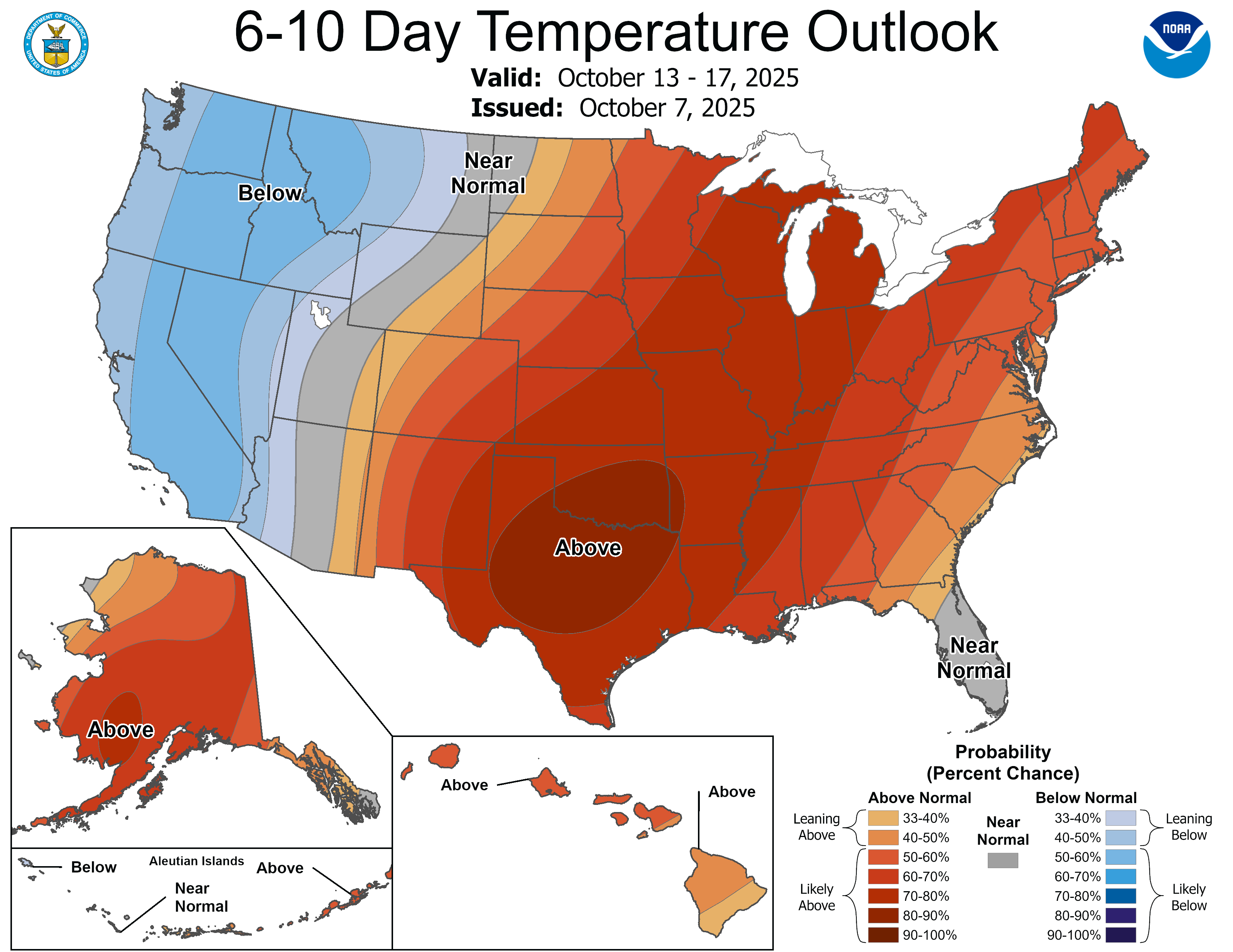
The start of next week looks cool, but the European Centre for Medium-Range Weather Forecasts model cranks out highs int he 70s again by later next week. Overall, next week favors warmer-than-normal temperatures across our region with colder air lurking to the west.
Stay tuned.

