
4th longest growing season in the Twin Cities finally ends
199 days between freezes this year from April to late October

Go Deeper.
Create an account or log in to save stories.
Like this?
Thanks for liking this story! We have added it to a list of your favorite stories.


“It was a nice summer.” — Anonymous Minnesotans this time of year
We finally hit rock bottom.
Well, the temperature bottomed out below freezing anyway in the Twin Cities for the first time this fall.
Friday morning’s minimum temperature of 30 degrees at Minneapolis-St. Paul International Airport is the first freezing temperature since April 8 when the mercury bottomed at 24 degrees. That makes the 2025 growing season in the Twin Cities an extended 199 days.
How does that compare to normal?
Turn Up Your Support
MPR News helps you turn down the noise and build shared understanding. Turn up your support for this public resource and keep trusted journalism accessible to all.
Using MSP airport data, the long-term average growing season is about 172 days. So we had an extra 27 days of freeze-free mornings this year. That 199 days is about average for places like Lawrence, Kan., or Kansas City, Mo.! So the Twin Cities enjoyed a Kansas-type growing season this year.
It looks like this will be the fourth longest growing season on record in the Twin Cities pending final numbers.
We set a record for the longest growing season on record in 2016 with an astounding 219 days between freezes that year. The temperature stayed above freezing at Minneapolis-St. Paul International Airport that fall until Nov. 18!

Here’s more on that 2016 record growing season from the Minnesota Department of Natural Resources:
In 2016 the Twin Cities observed its longest frost-free season on record, tallying 219 consecutive days without a 32 degree F reading at the MSP airport. The first such reading of the 2016 fall was also by far the latest on record, and did not come until November 18th--11 days later than the old record of November 7, set in 1900. The Twin Cities "threaded" record for these purposes extends back to 1873.
Historically, roughly 90% of autumn seasons produce a 32 degree F reading in the Twin Cities by October 28, and the first freezing reading has occurred in November just eight times (including 2016). Although the autumn season has warmed rapidly in the last several decades, all of the other November first-freeze dates were in the 20th and 19th centuries, with the most recent one on November 6, 1958.
Pretty decent weekend ahead
A warm front brings a few mostly light showers overnight into early Saturday morning. On the map below the National Oceanic and Atmospheric Administration’s FV3 model shows the trend.
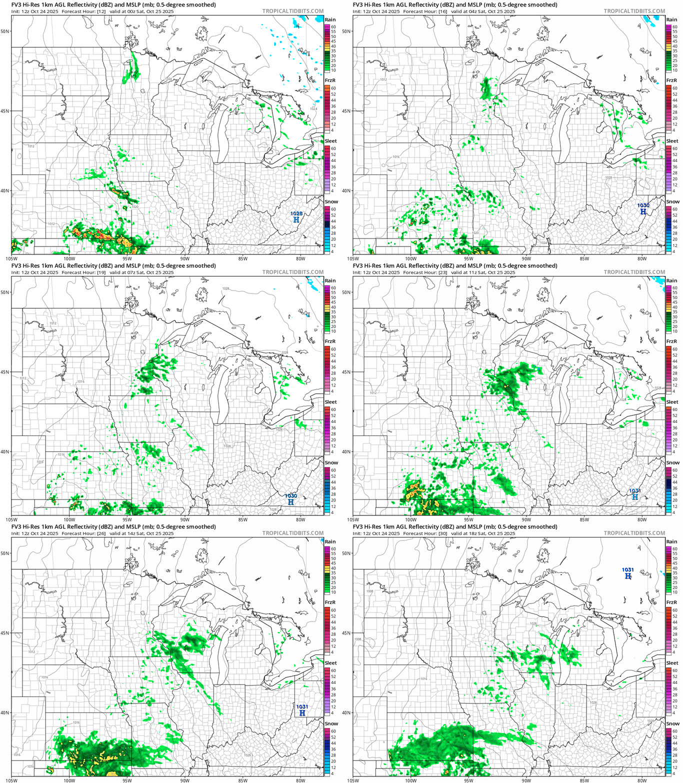
But it looks like we’ll see mixed sun Saturday afternoon with highs in the 50s.

Sunday looks like the sunnier, nicer day of the weekend.
Highs will push into the 60s in the Twin Cities and southwestern Minnesota.

The still early read on Halloween favors just a slight shower chance with temperatures in the 30s north to 40s south.
Freshwater Minnesota Weatherguide calendar 50th anniversary celebration
If you’re a fan of cool weather information, you can join us at the 50th Anniversary celebration for the Freshwater Minnesota Weatherguide calendar next Thursday morning.

Fellow meteorologist Belinda Jensen from KARE11 will be there along with several contributors from the calendar.
I’ll join Belinda in a discussion with Peter Boulay from the Minnesota Department of Natural Resources State Climatology Office and David Grack from the Jeffers Foundation to talk about the history of Minnesota’s best-selling calendar.
Enjoy the weekend!

