
Storm update: Snowfall totals and high winds increasing into Wednesday morning.
Snow piling up in central Minnesota. Difficult travel in parts of Minnesota.

Go Deeper.
Create an account or log in to save stories.
Like this?
Thanks for liking this story! We have added it to a list of your favorite stories.


Here’s an update on our feisty late November wintry storm across Minnesota. Winter storm warnings continue for most of Minnesota into Wednesday morning.
Snowfall totals so far
Snowfall rates of 1 to 2 inches per hour have dumped some impressive snowfall totals across central Minnesota. It is still snowing across much of central Minnesota.
Here are some early snowfall totals as of 9 p.m. Tuesday evening.
Turn Up Your Support
MPR News helps you turn down the noise and build shared understanding. Turn up your support for this public resource and keep trusted journalism accessible to all.
Baxter [Crow Wing Co, MN] Public reports Snow of 7.00 Inch at 25 Nov, 9:26 PM CST -- Report received via Facebook of 7 inches in Baxter. Location is approximate.
Rothsay [Wilkin Co, MN] Public reports Snow of 7.00 Inch at 25 Nov, 8:00 PM CST -- Picture shared on social media. Still very light snow at time of report but main event is over.
Pelican Rapids [Otter Tail Co, MN] Trained Spotter reports Snow of 6.30 Inch at 25 Nov, 4:45 PM CST -- Picture of snow with ruler shared. Snow still ongoing at time of measurement.
1 W Chokio [Stevens Co, MN] Trained Spotter reports Snow of 6.00 Inch at 4:00 PM CST -- 6 inches reported as of 4 PM. Snow ongoing.
2 S Fargo [Cass Co, ND] Broadcast Media reports Snow of 5.80 Inch at 25 Nov, 8:28 PM CST -- Event total snowfall measured at KVLY station.
3 NW Brainerd [Crow Wing Co, MN] Trained Spotter reports Snow of 5.00 Inch at 25 Nov, 6:48 PM CST -- Snow intensity has diminished somewhat, with less of the larger flakes falling. Still falling at time of observation.
2 SW Garfield [Douglas Co, MN] Trained Spotter reports Snow of 5.00 Inch at 25 Nov, 5:00 PM CST -- Measured during a brief lull. More snow expected this evening.
NWS Duluth [St. Louis Co, MN] Official NWS Obs reports Snow of 4.50 Inch at 25 Nov, 9:00 PM CST -- Measured an additional 3.3 inches since the 6 PM update. Snow was falling at a moderate rate at time of observation.
Highs winds
Winds have gusted as high as 60 mph in South Dakota. A wind gust of 58.7 mph was clocked in Tracy, Minnesota at 6:55 p.m. A 58.7 mph wind gust was also clocked in Jackson, Minnesota at 8:55 p.m.
(Tracy, MN (TKC) ASOS reports gust of 51 knots (58.7 mph) from NW @ 0055Z)
(JACKSON MUNI,MN (MJQ) ASOS reports gust of 51 knots (58.7 mph) from NW @ 0255Z)
Overnight forecast
The storm is spinning through Minnesota overnight. Winds and snow will increase on the backside of the system as it moves by. Rain has just changed to snow as of 9 p.m. at my locations here at the Weather Lab in the southwest Twin Cities.
NOAA’s latest (0Z) HRRR model run seems to have a good handle on the snow zone moving through overnight as the system pushes east. The forecast model loop below runs between 9 p.m. Tuesday and 9 a.m. Wednesday.
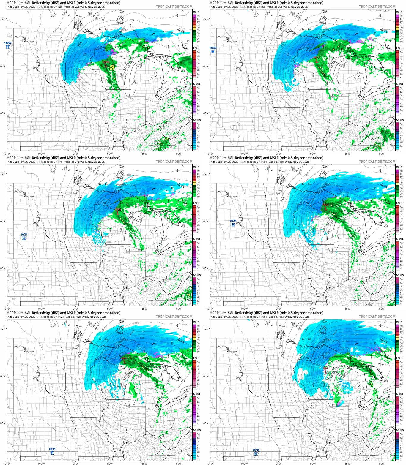
NOAA’s latest evening HRRR model snowfall output still favors a range of between 2 and 6 inches across the Twin Cities from far south to far north. Many locations in the heart of the Twin Cities may end up with 3 to 5 inches at the storms current pace. We’ll likely lose a the first inch from melting on contact until the snow accumulated given warm ground.

Wednesday morning’s rush hour will be windy and potentially icy slick with temperatures falling into the 20s.
Plan for some extra time Wednesday morning if you have to travel!

