
Winter storm update: Heavy snow, high winds increasing through Tuesday night
Winter storm, blizzard warnings posted; Twin Cities set for heavy snow into Wednesday

Go Deeper.
Create an account or log in to save stories.
Like this?
Thanks for liking this story! We have added it to a list of your favorite stories.


The season’s first major wintry storm is cranking up in intensity across Minnesota Tuesday afternoon. As of this update, it’s snowing heavily in much of west-central Minnesota.

I’m seeing surface reports Tuesday afternoon of heavy snow in northwestern Minnesota along Interstate 94 between Fargo-Moorhead and Alexandria. Visibility in the region is less than one-quarter mile, indicating snowfall rates of 1 to 2 inches per hour!

It’s raining in the milder air around the Twin Cities. We may even hear a clap of thunder before rain change to snow Tuesday evening around the Twin Cities.
Winter storm warnings are posted for most of Minnesota, including the Twin Cities area:
Turn Up Your Support
MPR News helps you turn down the noise and build shared understanding. Turn up your support for this public resource and keep trusted journalism accessible to all.
URGENT - WINTER WEATHER MESSAGE National Weather Service Twin Cities/Chanhassen MN 155 PM CST Tue Nov 25 2025
...RAIN WILL TURN TO HEAVY SNOW FROM WEST TO EAST THIS AFTERNOON AND TONIGHT... ...SNOWFALL RATES EXCEEDING AN INCH PER HOUR AND STRONG NORTHWEST WINDS GUSTING TO 45 MPH MAY LEAD TO BLIZZARD CONDITIONS AT TIMES...
A potent storm system will move across the area today and tonight. Rain will transition snow from west to east as cold air arrives. Periods of heavy snow are expected with rates of around an inch per hour at times. The heaviest totals will be found across central Minnesota and northwest Wisconsin where around 6 inches are expected. Farther south across southern Minnesota and parts of west central Wisconsin, 1 to 3 inches are expected. Winds will increase later today and tonight with gusts as high as 45 mph. Combined with the falling snow, widespread blowing snow and blizzard conditions are possible at times with visibilities 1/4 mile or less. The Winter Storm Warning remains in effect for central and most of southern Minnesota and northwest Wisconsin. A Winter Weather Advisory is in effect for far southern Minnesota and parts of west central Wisconsin.
Let’s break down to storm and update storm progress and impacts through Tuesday night into Wednesday morning.
The system
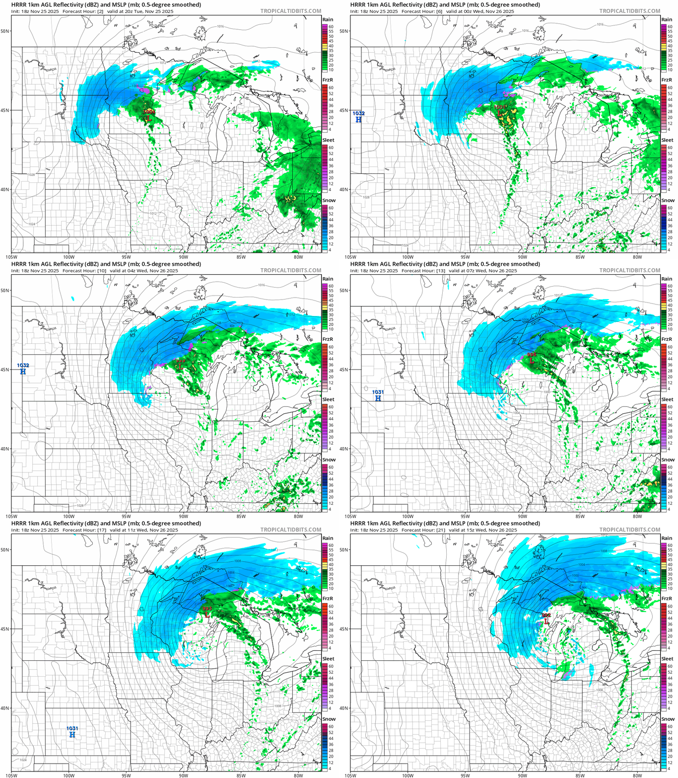
Our potent early season wintry storm is tracking across Minnesota through Tuesday night.
I flagged that accelerating trend late Monday evening of a further jog south in storm track. That’s what brought winter storms warnings further south including the Twin Cities and much of southern Minnesota.
The heaviest snowfall zone will still be north of the Twin Cities across central and northeastern Minnesota. Rain and even a clap of thunder will change to snow Tuesday evening in the Twin Cities from northwest to southeast between about 6 and 10 p.m.
On the map below, the National Oceanic and Atmospheric Administration’s latest (18Z) HRRR model shows the storm tracking through Minnesota. The forecast model loop runs between 2 p.m. Tuesday and 9 a.m. Wednesday.
Snowfall totals
The heaviest snowfall will still occur across central and northeast Minnesota with this storm. (See the map at the top of the post.) But the southward jog has boosted snowfall expectations in the Twin Cities and parts of southern Minnesota.
I’ve looked at many forecast models and the latest National Weather Service snowfall projection below looks reasonable for the Twin Cities and southern Minnesota. A range of 3 to 6 inches looks likely for the Twin Cities with higher totals to 8 inches possible in the far northern Twin Cities.

Travel impacts
Travel is already poor with heavy blowing snow across northwestern and central Minnesota Tuesday afternoon.
Travel will deteriorate Tuesday evening through Wednesday morning for the Twin Cities and southern Minnesota. Wind gusts greater than 50 mph are possible Tuesday night and some locations in south-central Minnesota could see 60-mph gusts overnight.
Roads will be near impassable and drifting over with blowing snow in many areas overnight into early Wednesday.
Temperatures are falling through the 30s and will hover in the 20s across Minnesota Wednesday. Ice and compact snow will be an issue, and Wednesday morning’s commute in the Twin Cities looks slick and slow.

Snow will end in eastern Minnesota from west to east Wednesday morning, but gusty winds will cause blowing snow in open areas into Wednesday afternoon. Travel should gradually improve Wednesday afternoon and evening.
Right now, Thanksgiving Day travel looks dry. There is another chance of snow Friday night into Saturday.
Early indications are a bigger storm heading toward Iowa and southern Wisconsin could clip southern Minnesota, including the Twin Cities, with a couple inches of snow, with heavier totals possible in southeastern Minnesota.
Please travel safely and stay tuned for updates!

