
Ferocious storm damaged trees, dropped heavy snow across Minnesota
Storm-releated death near Two Harbors; high winds, sticky snow felled trees

Go Deeper.
Create an account or log in to save stories.
Like this?
Thanks for liking this story! We have added it to a list of your favorite stories.


Welcome to instant winter in Minnesota and the entire Upper Midwest.
Our first real widespread wintry storm caused serious problems for many in our region. This particular system delivered a combination of high winds and sticky snow that coated trees and roadways.
I’m seeing numerous reports of tree damage due to high winds and sticky snow accumulation on trees making them more susceptible to damage from high winds. Here’s one:
1 SW Lester Park [St. Louis Co, MN] 911 Call Center reports Snow/Ice Dmg at 10:56 AM CST -- Tree on powerline and on fire.
Unfortunately, storm reports show a man was killed by a falling tree near Two Harbors Wednesday morning.
Turn Up Your Support
MPR News helps you turn down the noise and build shared understanding. Turn up your support for this public resource and keep trusted journalism accessible to all.
High winds
This was not your average pretty snowfall in Minnesota.
Winds gusting from 50 to greater than 60 mph pasted the sticky snow on anything standing including homes and trees.
Winds gusted to 64 mph on the Blatnik Bridge near Duluth and to 61 mph at Duluth harbor. Here are the highest wind gusts record in the area from the Duluth National Weather Service office:

Snowfall totals
This storm produced heavy wind-whipped snow across our region, as expected. The first inch that fell largely melted on contact on warm ground making it difficult to include in overall snowfall totals.
Double-digit snowfall occurred around Duluth and more than 12 inches of snow fell in the lake-effect zone in northwestern Wisconsin. Between 5 and 10 inches fell across a swath from west-central Minnesota through Duluth and the North Shore. Here are some totals, in inches:
Duluth National Weather Service office, 10.3
Kerrick, 10
Cloquet, Danbury, 9.5
Wheaton, 8.5
Two Harbors, 8.4
Brainerd, Baxter, 8
Deer Creek, 8
Grand Marais, 7.5
Wadena, 7.4
Pelican Rapids, Morris, 6.3
Chokio, 6
Fargo, N.D., area, 5.8
St. Cloud area, 4.8
Rochester, 2
Around the Twin Cities snowfall totals ranged from around 2 inches to 5.7 inches. Officially 3.1 inches fell at Minneapolis-St. Paul International Airport.
St. Francis, Brooklyn Park, and Ham Lake recorded 5-plus inches of new snow in the northern Twin Cities area. Here are some totals, in inches:
St. Francis, 5.7
Ham Lake, 5.3
Brooklyn Park, 5
Andover, 4.8
Roseville, 4.5
Minneapolis-St. Paul International Airport, 3.1
Apple Valley, 2.6
St. Paul, 2.4

Forecast: Quiet Thanksgiving Day
Our weather pattern mellows as we move into Thanksgiving Day. It will be cold but dry and travel should be fairly good through most of Black Friday with a mix of chilly sun and a few clouds. Highs will be in the 20s.
Possible snow Saturday
Forecast models are tracking the next snow system, which is expected Saturday across the Upper Midwest. This one looks likely to track the heaviest snowfall south of Minnesota across Iowa, southern Wisconsin into the Chicago area Saturday into early Sunday.
Models project some snow from basically the Twin Cities south on Saturday. The Canadian and American models suggest plowable snow for the Twin Cities and southern Minnesota.
The European model takes a more southern track and just grazes the Twin Cities with light snow Saturday. The European model forecast model loop below runs between 6 p.m. Friday and noon Sunday.
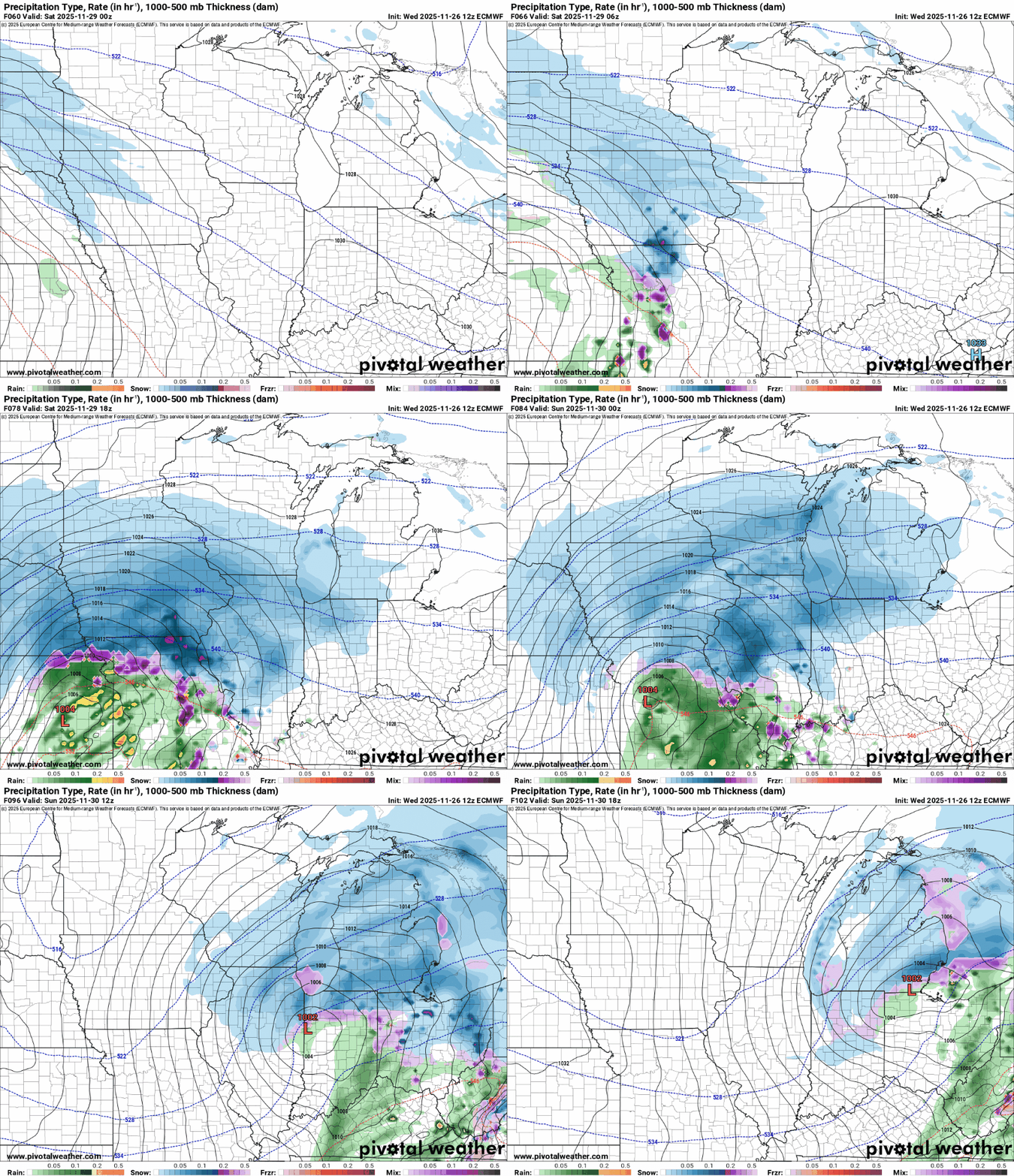
It’s still too early to pinpoint snowfall zones and totals for the Saturday system. The actionable weather forecast right now is to expect snow if you are traveling southward Friday night through Saturday.
Travel to and from places like Des Moines, Iowa, Madison, Wis., or Chicago will be better Thursday and Friday, and then again Sunday. Travel north of the Twin Cities should be better Saturday.
Stay tuned.

