
Clipper parade: Winter storm warnings include northern Twin Cities
Heavy snow, ice, and rain likely across different parts of Minnesota Tuesday.

Go Deeper.
Create an account or log in to save stories.
Like this?
Thanks for liking this story! We have added it to a list of your favorite stories.


Here’s an update on inbound wintry storm system Tuesday. Let’s start with the evolving warning landscape. Warning and advisory zones may shift a bit as the system approaches Tuesday.

Winter storm warnings have been expanded southward to include the northern Twin Cities Tuesday. Here’s the updated storm synopsis for the northern Twin Cities areas from the Twin Cities NWS:
URGENT - WINTER WEATHER MESSAGE National Weather Service Twin Cities/Chanhassen MN 315 PM CST Mon Dec 8 2025
...POTENTIAL FOR HEAVY, ACCUMULATING SNOW AND VERY GUSTY WINDS FROM CENTRAL MINNESOTA TO WESTERN WISCONSIN TUESDAY AFTERNOON THROUGH TUESDAY NIGHT...
A strong clipper system is forecast to bring accumulating, potentially heavy, snow to portions central and eastern Minnesota and western Wisconsin Tuesday through Tuesday night. Snow is expected to start in central Minnesota early Tuesday afternoon and spread southeast into western Wisconsin by Tuesday evening.
Currently, the most likely place for heaviest snow is along and north of Interstate 94 where a narrow band of 4 to 7 inches of snow is possible. Winds will also become strong with gusts of 30 to 40 mph possible. Snow will end from west to east during the morning hours of Wednesday.
Here’s the updated winter storm warning for the northern Twin Cities.
Todd-Morrison-Mille Lacs-Kanabec-Benton-Sherburne-Isanti-Chisago- Anoka- Including the cities of Princeton, Mora, Sauk Rapids, Elk River, Long Prairie, Little Falls, Center City, Cambridge, and Blaine
315 PM CST Mon Dec 8 2025
...WINTER STORM WARNING IN EFFECT FROM NOON TUESDAY TO 6 AM CST WEDNESDAY...
* WHAT...Heavy snow expected. Total snow accumulations between 4 and 7 inches. Winds gusting as high as 40 mph.
* WHERE...Benton, Morrison, Sherburne, Todd, Anoka, Chisago, Isanti, Kanabec, and Mille Lacs Counties. * WHEN...From noon Tuesday to 6 AM CST Wednesday.
* IMPACTS...Roads, and especially bridges and overpasses, will likely become slick and hazardous. Travel could be very difficult. The hazardous conditions will impact the Tuesday evening commute.
Northwest Minnesota
Winter storm warnings now cover most of northwest Minnesota. Here’s the update for northwest Minnesota from the Red River Valley eastward through Thief River Falls:
Turn Up Your Support
MPR News helps you turn down the noise and build shared understanding. Turn up your support for this public resource and keep trusted journalism accessible to all.
Including the cities of Warren, Grand Forks, East Grand Forks, Devils Lake, Cavalier, Crookston, Finley, Ada, Hallock, Newfolden, Fosston, Lankin, Hillsboro, Mayville, Middle River, Drayton, Langdon, Halstad, Michigan, Red Lake Falls, Thief River Falls, and Grafton
146 PM CST Mon Dec 8 2025
...WINTER STORM WARNING IN EFFECT FROM 6 AM TUESDAY TO 6 AM CST WEDNESDAY...
* WHAT...Heavy mixed precipitation and widespread blowing snow expected. Total snow accumulations between 3 and 5 inches and ice accumulations around one tenth of an inch. Winds gusting as high as 60 mph.
* WHERE...Portions of northwest Minnesota and northeast and southeast North Dakota.
* WHEN...From 6 AM Tuesday to 6 AM CST Wednesday.
* IMPACTS...Roads, and especially bridges and overpasses, will likely become slick and hazardous. Whiteout conditions are expected and will make travel treacherous and potentially life-threatening.
Central Minnesota
And finally, here’s the warning language from the Duluth NWS Office covering central Minnesotan including the Brainerd, Mille Lacs and Hinckley area along I-35 south of Duluth:
South Cass-Crow Wing-South Aitkin-Pine- Including the cities of Pine River, Aitkin, Brainerd, Pine City, and Hinckley
218 PM CST Mon Dec 8 2025 ...WINTER STORM WARNING IN EFFECT FROM NOON TUESDAY TO 3 AM CST WEDNESDAY...
* WHAT...Heavy snow expected. Total snow accumulations between 4 and 6 inches. Locally higher amounts, up to 8 inches, are possible.
* WHERE...Crow Wing, Pine, South Aitkin, and South and Cass Counties. This includes the Tribal Lands of the Mille Lacs Band, East Lake, Hinckley and, Lena Lake areas.
* WHEN...From noon Tuesday to 3 AM CST Wednesday.
* IMPACTS...Travel could be very difficult. The hazardous conditions could impact the Tuesday evening commute.
Latest forecast models
We’ll watch for shifts in forecast models Monday evening into early Tuesday. Forecast models Monday afternoon continue to show the rain-ice-snow transition zone along the I-94 corridor through the Twin Cities area. Here’s NOAA’s NAM 3 km model between noon Tuesday and 6 a.m. Wednesday.
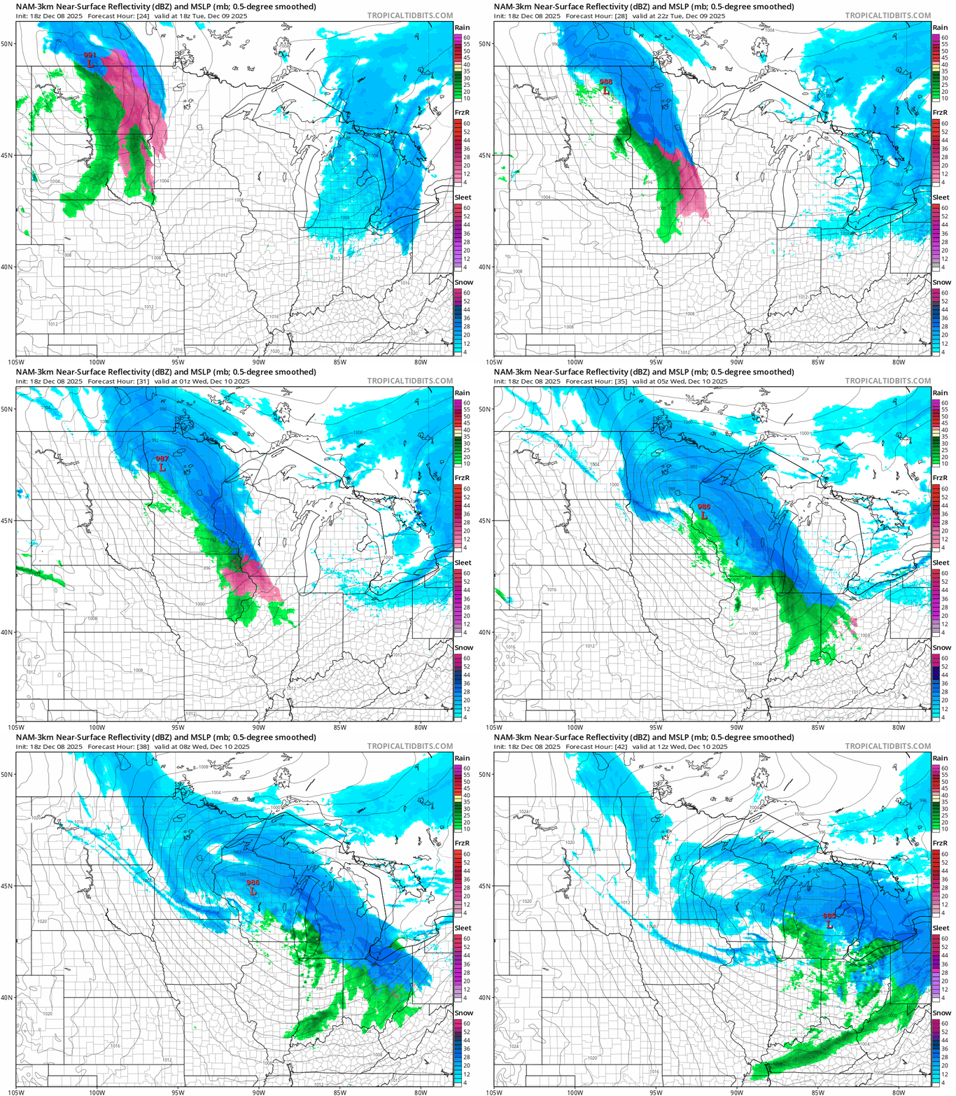
It still looks at this point like we’ll see a big snowfall range from southwest to northeast across the Twin Cites area. If the storm track shifts further south overnight we could see higher snowfall totals in the Twin Cities area.
Stay tuned.

