
Winter storm warning: Heavy snow likely Tuesday across central, northern Minnesota
Heavy snow north of I-94 may mix with ice, rain near the Twin Cities

Go Deeper.
Create an account or log in to save stories.
Like this?
Thanks for liking this story! We have added it to a list of your favorite stories.


Here we go again, Minnesota.
Our active December weather pattern is ready to deliver another messy storm to Minnesota Tuesday into early Wednesday.
Winter storm warnings are already posted for Tuesday across northwestern Minnesota and will expand south and east. Here’s the National Weather Service bulletin:
Including the cities of Warren, Grand Forks, East Grand Forks, Devils Lake, Cavalier, Crookston, Finley, Ada, Hallock, Newfolden, Fosston, Lankin, Hillsboro, Mayville, Middle River, Drayton, Langdon, Halstad, Michigan, Red Lake Falls, Thief River Falls, and Grafton
146 PM CST Mon Dec 8 2025
...WINTER STORM WARNING IN EFFECT FROM 6 AM TUESDAY TO 6 AM CST WEDNESDAY...
* WHAT...Heavy mixed precipitation and widespread blowing snow expected. Total snow accumulations between 3 and 5 inches and ice accumulations around one tenth of an inch. Winds gusting as high as 60 mph.
* WHERE...Portions of northwest Minnesota and northeast and southeast North Dakota.
* WHEN...From 6 AM Tuesday to 6 AM CST Wednesday.
* IMPACTS...Roads, and especially bridges and overpasses, will likely become slick and hazardous. Whiteout conditions are expected and will make travel treacherous and potentially life-threatening.
First, a little lead wave is bringing lighter snow to central and northern Minnesota through Monday night. A band of 1 to 2 inches of snow will favor areas north of the Twin Cities into early Tuesday. Then the main system arrives Tuesday into Wednesday.
Turn Up Your Support
MPR News helps you turn down the noise and build shared understanding. Turn up your support for this public resource and keep trusted journalism accessible to all.
Let’s break down the next big weather system heading for Minnesota Tuesday.
The system
Our next big snow maker for Minnesota is essentially a potent Alberta clipper-style storm. It will race from northwest to southeast across Minnesota Tuesday into early Wednesday.
Snow will begin in the Red River Valley in northwestern Minnesota later Tuesday morning then spread quickly across central and parts of northern Minnesota.
The leading edge of the main snow-rain-ice wave should reach the Twin Cities early to midafternoon Tuesday. The heaviest snow will occur Tuesday evening through Tuesday night before ending from west to east Wednesday morning.
It looks most likely that we’ll see moderate to heavy snowfall rates from the northern Twin Cities northward by Tuesday evening’s rush hours. Precipitation could be an icy or even rainy mix in the Twin Cities.
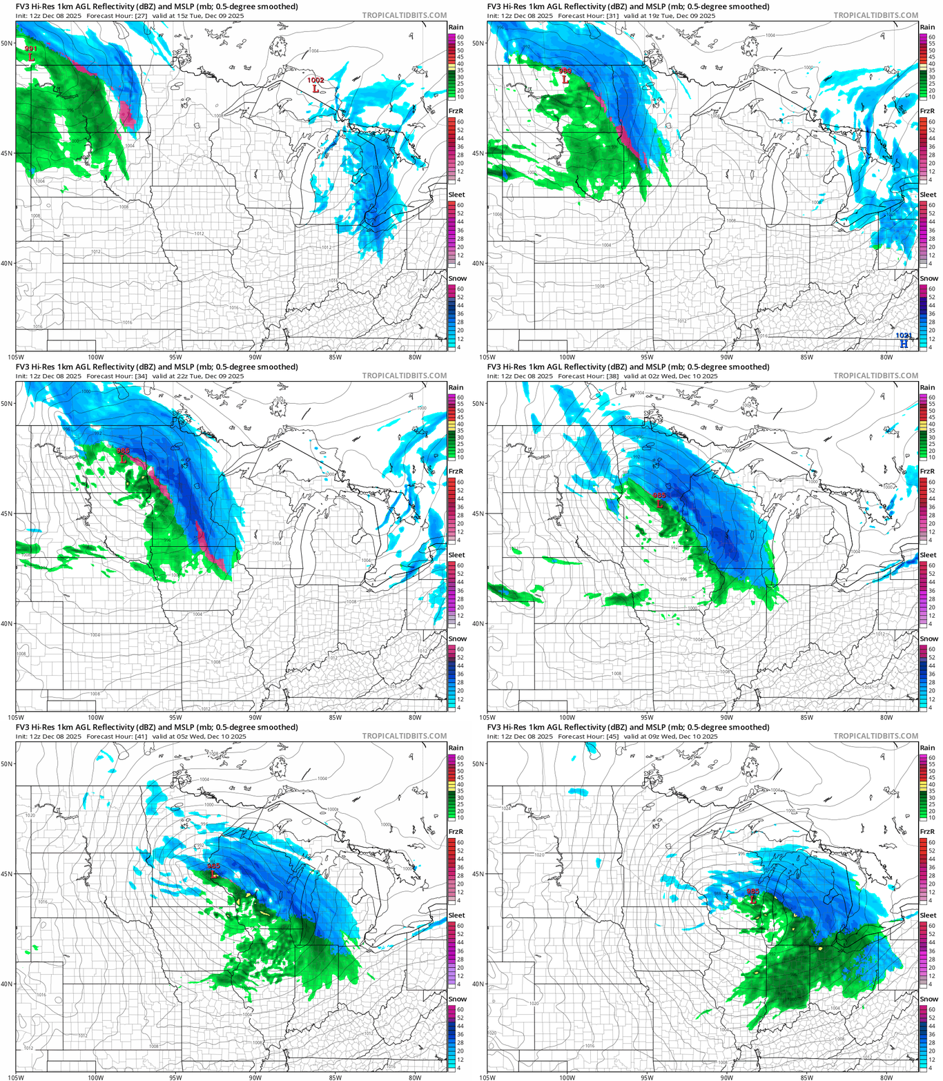
The National Oceanic and Atmospheric Administration’s FV3 model seems to be in the middle of the forecast envelope for storm track and precipitation types. The forecast model loop below runs between 9 a.m. Tuesday and 3 a.m. Wednesday.
Note the mixed precipitation in the Twin Cities and the heavy snow bands to the north across central Minnesota.
Snowfall potential
The most likely area for heavy snowfall favors areas north of the Interstate 94 corridor through much of central and northern Minnesota. The main area of uncertainty lies along I-94 and points southward — right through the greater Twin Cities area.
As usual, there are several different forecast model solutions for this storm.
The latest available European Centre for Medium-Range Weather Forecasts model tracks the system farther north and keeps the heaviest snow north of the Twin Cities.
NOAA’s Global Forecast System model is the southern outlier and brings heavy snow farther southward into parts of the Twin Cities area.
Short-range models such as NOAA’s High-Resolution Rapid Refresh model favor more mixed precipitation in the Twin Cities with heavy snow mostly north of the Twin Cities area through Tuesday night.
Here’s a closer look at the likely steep snow gradient across the Twin Cities area from southwest to northeast:

Expect rough travel Tuesday through Tuesday night across our region. Let’s see where the forecast models push the storm track through Monday night.
Stay tuned.

