
Potent clipper delivers snow; high winds and arctic air next
Blizzard conditions possible Wednesday in SW Minnesota into Iowa

Go Deeper.
Create an account or log in to save stories.
Like this?
Thanks for liking this story! We have added it to a list of your favorite stories.


Our latest Alberta clipper delivered on forecasts of moderate to heavy snow across much of Minnesota Tuesday. The heaviest snow bands favored areas along and north of the Interstate 94 corridor as forecast models laid out.
Winter storm warnings continue into early Wednesday for most areas.

It is still snowing as of this update Tuesday evening. Here are some preliminary snowfall totals through Tuesday afternoon.
1 E Baxter [Crow Wing Co., Minn.] Public reports Snow of 5.00 Inch at 5:38 p.m. CST — Light fluffy snow falling at observation time.
5 E Leader [Cass Co., Minn.] Trained Spotter reports Snow of 5.00 Inch at 5:00 p.m. CST — Snow so far. Still snowing.
Perham [Otter Tail Co., Minn.] Public reports Snow of 4.00 Inch at 1:53 p.m. CST — Relayed from broadcast media.
3 NNW Brainerd [Crow Wing Co., Minn.] Public reports Snow of 3.50 Inch at 4:50 p.m. CST — Update to previous report. 1 inch of additional snowfall since 3:55 p.m.
Moorhead [Clay Co., Minn.] Broadcast Media reports Snow of 3.20 Inch at 4:26 p.m. CST — Occasional ice pellets as well.
2 SSE Grand Forks [Grand Forks Co., N.D.] Public reports Snow of 3.00 Inch at 4:31 p.m. CST.
Snowfall tapers Tuesday evening from west to east. But another shot of snow is likely overnight on the systems windy backside.
Turn Up Your Support
MPR News helps you turn down the noise and build shared understanding. Turn up your support for this public resource and keep trusted journalism accessible to all.
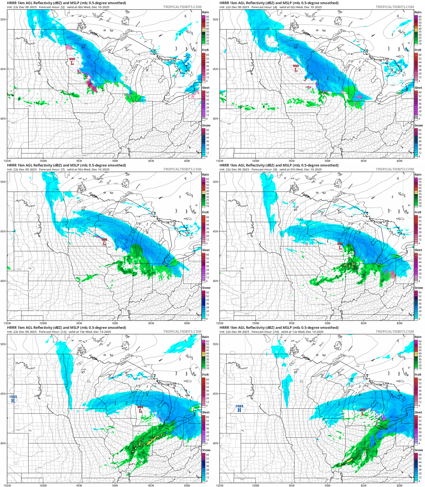
On the map below, the National Oceanic and Atmospheric Administration’s latest High-Resolution Rapid Refresh model shows the storm racing eastward overnight.
High winds into Wednesday
The next phase of the storm features high winds on the storm’s backside. Gusts greater than 50 mph are likely across southwestern Minnesota. Wind gusts could reach 60 mph across eastern South Dakota and Iowa!

Arctic blast ahead
The inbound air mass behind this system will bring subzero low temperatures and wind chills by the weekend.
Highs will hover in the single digits this weekend and lows will bottom out Sunday morning in the teens below around the Twin Cities to 20s below in the north.

There are signs of a thaw next week with highs back into the 30s. Above zero.
Stay tuned.

