
Storm update: Winter storm warning expands to NE Twin Cities region
Heavy snow in central, NW Minnesota; icy mix for Twin Cities into Tuesday evening

Go Deeper.
Create an account or log in to save stories.
Like this?
Thanks for liking this story! We have added it to a list of your favorite stories.


Our latest wintry storm is delivering severe winter weather to Minnesota and the Upper Midwest. Winter storm warnings include the northeast Twin Cities region. Here’s the National Weather Service bulletin:
Todd-Morrison-Mille Lacs-Kanabec-Benton-Sherburne-Isanti-Chisago- Anoka- Including the cities of Center City, Cambridge, Sauk Rapids, Elk River, Little Falls, Long Prairie, Princeton, Mora, and Blaine
242 AM CST Tue Dec 9 2025
...WINTER STORM WARNING REMAINS IN EFFECT FROM NOON TODAY TO 6 AM CST WEDNESDAY...
* WHAT...Heavy mixed precipitation expected. Total snow accumulations between 4 and 7 inches and ice accumulations around a light glaze. Winds gusting as high as 40 mph.
* WHERE...Benton, Morrison, Sherburne, Todd, Anoka, Chisago, Isanti, Kanabec, and Mille Lacs Counties.
* WHEN...From noon today to 6 AM CST Wednesday.
* IMPACTS...Roads, and especially bridges adnesday.
* IMPACTS...Roads, and especially bridges and ovnd overpasses, will likely become slick and hazardous. Travel could be very difficult. The hazardous conditions will impact the Tuesday evening commute.
Here is where we stand with the system and current and forecast weather conditions as of midday Tuesday.
Storm track
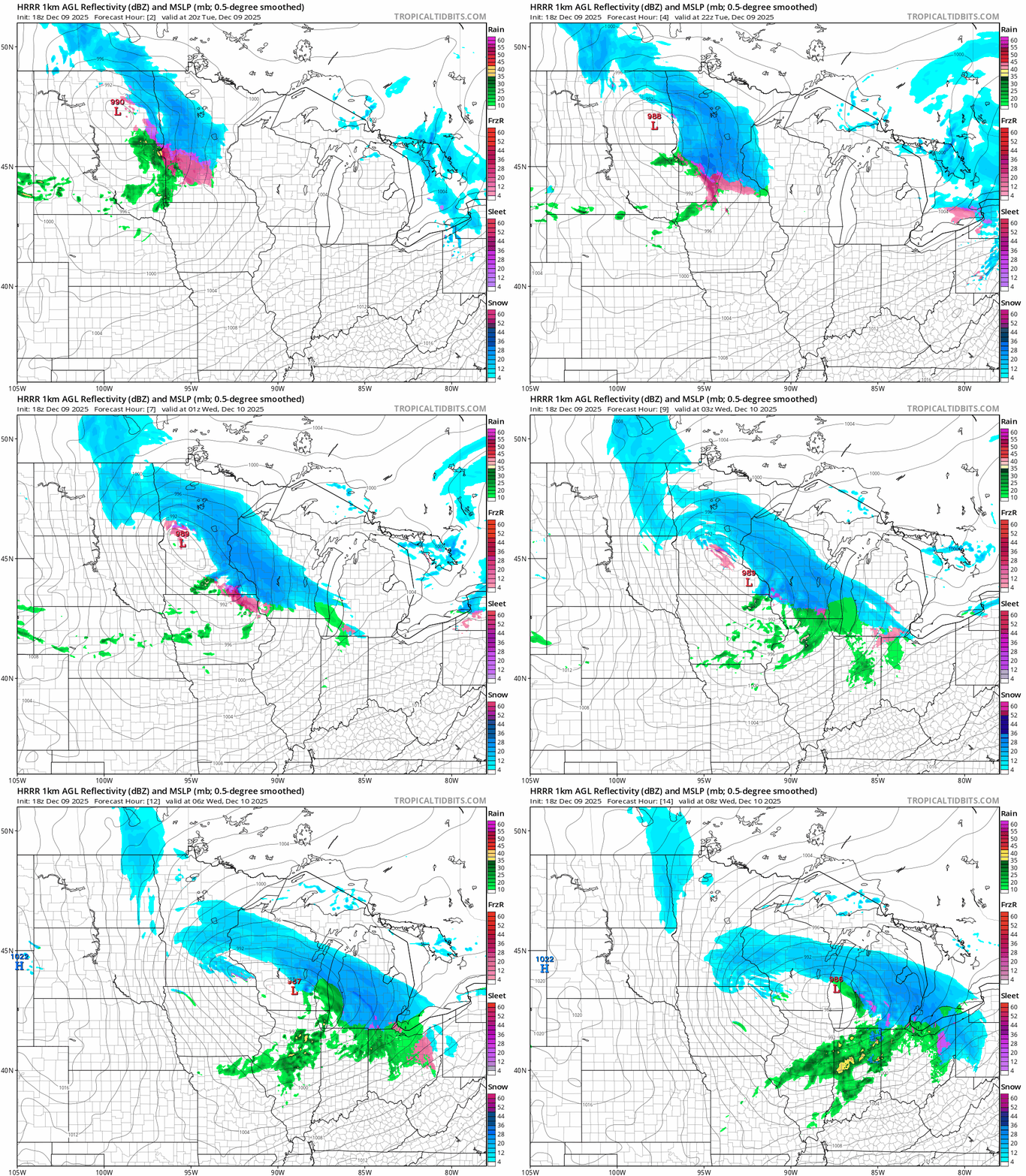
The storm track remains pretty much in line with the forecast model trends form Monday’s runs. A few short-range forecast models have trended a bit farther south with snowfall. That could produce higher snowfall totals in the core of the Twin Cities.
On the map below, the National Oceanic and Atmospheric Administration’s latest 18Z High-Resolution Rapid Refresh model shows the trend of an icy mix with some heavy snow bands pushing through the Twin Cities Tuesday evening.
Turn Up Your Support
MPR News helps you turn down the noise and build shared understanding. Turn up your support for this public resource and keep trusted journalism accessible to all.
Heavy snowfall rates
The system is already producing heavy snowfall rates as expected in northwest into central Minnesota. Visibility in moderate to heavy snow is between one-quarter and one-half mile in the Red River Valley into northwestern Minnesota as of early Tuesday afternoon.
This represents snowfall rates of at least 1 inch per hour. NOAA’s Storm Prediction Center has highlighted that area for 1 inch per hour snowfall rates for the next several hours.

Twin Cities: Icy mix
A mix of snow and icy precipitation is increasing across the Twin Cities through the evening.
Rush hours will be dicey especially the further north you travel across the greater Twin Cities area. Heavy snow bands are looking more possible across the Twin Cities Tuesday night.
Snowfall totals
Forecast models still place the heaviest snow north of the Twin Cities across central Minnesota.

Recent trends indicate some higher snowfall totals could drift south into the Twin Cities.

It’s possible we may see some 4 to 6 inch totals creep into the central Twin Cities by Wednesday morning.
High winds tonight and Wednesday
Winds will pump up to 50 mph behind the storm Tuesday night and Wednesday. This will cause severe blowing snow with near-blizzard conditions possible especially in southwestern Minnesota, eastern South Dakota and Iowa where plenty of snow is on the ground already.

Weather conditions will gradually improve Wednesday afternoon.
Stay safe out there, Minnesota!

