
January thaw ahead, then colder with some snow late this week
Storm system may bring accumulating snow to SE Minnesota Thursday into Friday

Go Deeper.
Create an account or log in to save stories.
Like this?
Thanks for liking this story! We have added it to a list of your favorite stories.


It’s a sloppy Tuesday out there around Minnesota. This morning’s icy accumulations linger especially north of the Twin Cities where temperatures are still in the 20s. Temperatures hung around the freezing mark with a mix of rain and ice in the Twin Cities.
Several locations in central and northeastern Minnesota into Wisconsin reported icy accumulations Tuesday morning. Here’s a sampling of reports to the National Weather Service:
3 E Payne in St. Louis County, a trained spotter reports freezing rain of 0.03 inch at 6:44 a.m. CST — Freezing drizzle and light freezing rain. Ice accumulation on all surfaces.
4 NE Hermantown in St. Louis County, ASOS reports freezing rain of 0.01 inch at 10:55 a.m. CST — ASOS station KDLH Duluth International Airport.
1 SW Grantsburg in Burnett County, Wis., Cocorahs reports rain of 0.08 inch at 8 a.m. CST — Observer reported just under a tenth of an inch of ice on snow boards. Precip measured at 0.04 inches. Cocorahs station WI-BT-21 Grantsburg 0.6 SW (KWIGRANT1).
1 SSW Pine City in Pine County, Cocorahs reports rain of 0.01 inch at 7 a.m. CST — Ice on snow board and rain gauge. Cocorahs station MN-PN-32 Pine City 0.7 SSW.
5 NE Cohasset in Itasca County, Cocorahs reports freezing rain of 0.01 inch at 7 a.m. CST — Corrects previous freezing rain report from 5 NE Cohasset. Observer reported a moderate coating of freezing rain/fog on snow board. Cocorahs station MN-IT-17 Grand Rapids 6.1 N.
7 NNW Knife River in St. Louis County, Cocorahs reports Freezing Rain of 0.01 Inch at 7 a.m. CST — Corrects previous freezing rain report from 7 NNW Knife River. Observer reported minimal amount of freezing rain in gauge. Cocorahs station MN-SL-313 Two Harbors 8.4 W.
Temperatures to the southwest of Minnesota are much milder Tuesday afternoon with 50s as far north as Nebraska.

January thaw ahead
A milder Pacific air mass eases into Minnesota Wednesday. Highs Wednesday afternoon will reach the 40s in southwest Minnesota and be above freezing across most of our state.
Turn Up Your Support
MPR News helps you turn down the noise and build shared understanding. Turn up your support for this public resource and keep trusted journalism accessible to all.
Skies will be mostly cloudy, but if we break into any significant sunshine in the Twin Cities Wednesday afternoon we’ll have no trouble reaching the 40-degree mark.

The mild weather linger into Thursday.
Storm passing south Thursday into Friday
Forecast models favor a significant rain event across Iowa and Wisconsin late Thursday into Friday. It looks cold enough for snow on the northwest edge of the system as it passes over southeastern Minnesota into Friday.
Right now, it appears the snow edge will track just southeast of the Twin Cities but it’s close enough to keep an eye on for any shift north.
The European Centre for Medium-Range Weather Forecasts model shows the latest storm track between noon Thursday and midnight Friday.
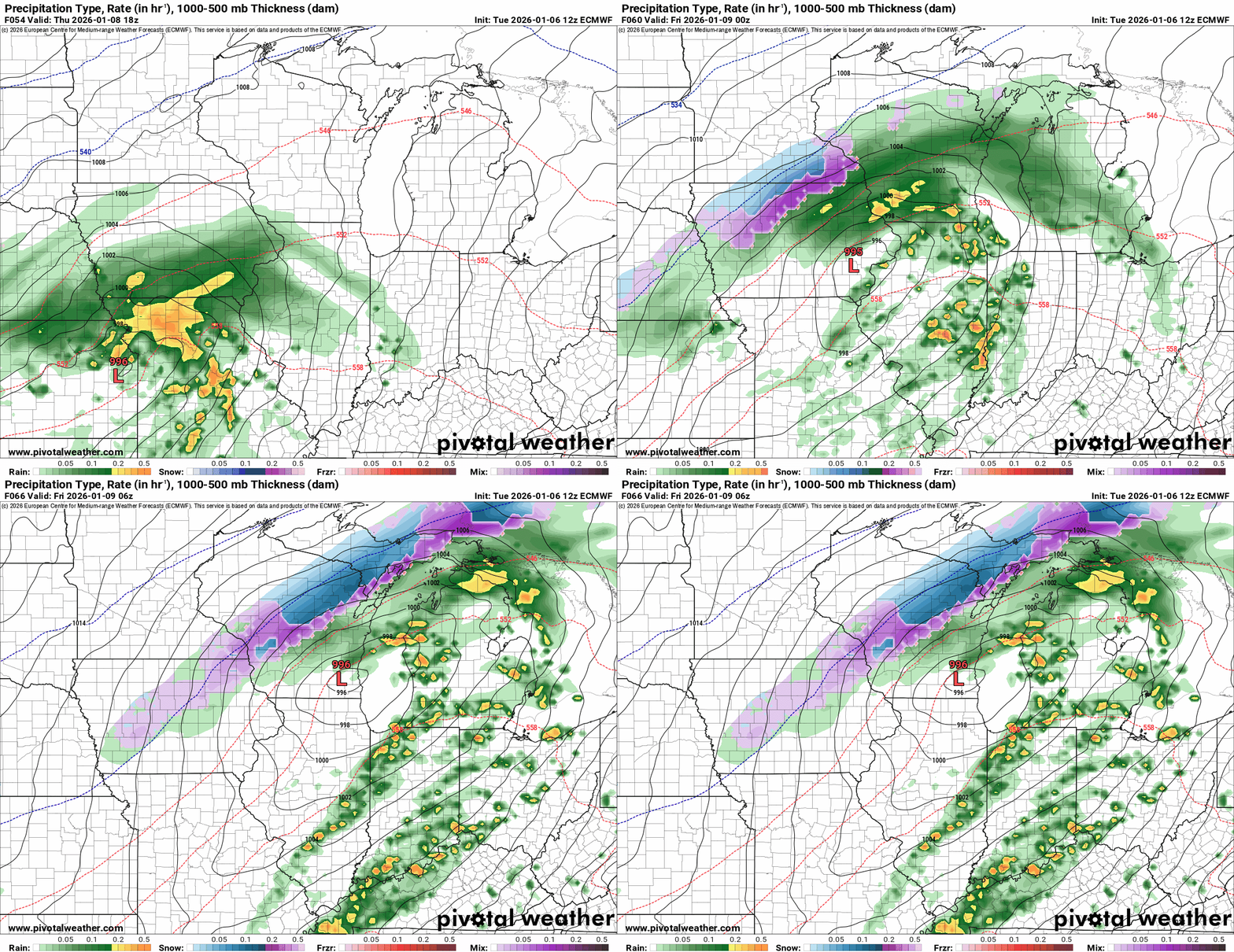
The European model snowfall output favors a zone of 1 to 3 inches across southeastern Minnesota with heavier totals into northeastern Wisconsin by Friday morning.

Right now, the weekend looks colder with occasional bouts of light snow and flurries Saturday.

We could cobble together a couple of inches of snow by Sunday morning around most of Minnesota as the colder air squeezes out residual moisture.

Stay tuned.

