
Gradually milder weekend; clipper brings light snow Sunday
1-3 inches of snow possible Sunday in NW Minnesota

Go Deeper.
Create an account or log in to save stories.
Like this?
Thanks for liking this story! We have added it to a list of your favorite stories.


We’re easing out of what was likely the coldest run of winter. The temperature dipped to minus 1 degree Friday morning at Minneapolis-St. Paul International Airport.
That’s our 17th subzero day in the Twin Cities this season. So we’re on pace to get to the seasonal average of 22 subzero days. We typically see about another five days of subzero temperatures through February into the first week of March.
Saturday brings another frigid start to Minnesota. Overnight lows will dip below zero once again.

Sunshine and light winds Saturday will help boost temperatures in the teens in the south by afternoon. It’s amazing how good a sunny 16 degrees can feel after an extended subzero run.
Turn Up Your Support
MPR News helps you turn down the noise and build shared understanding. Turn up your support for this public resource and keep trusted journalism accessible to all.

Sunday brings even milder temperatures. Bank thermometers will flash 30 degrees in southwestern Minnesota Sunday afternoon. Sunday will be the first warmer-than-normal day in two weeks for most of Minnesota! Baby steps people.

Weekend clipper
A weak to moderate clipper will cross Minnesota into Sunday. It looks like snow will begin in the Red River Valley and northwestern Minnesota Saturday afternoon and expand east into Saturday night.
Right now, it looks like the snow zone will reach the Twin Cities area sometime around or after midnight Saturday night.
Snow will gradually taper off from west to east Sunday. The heaviest snow hours in the Twin Cities favor Sunday morning but we could get another vigorous shot in the afternoon before the snow ends.
On the map below, the National Oceanic and Atmospheric Administration’s latest (18Z) NAM 3 km model shows the snow trend between 3 p.m. Saturday and 6 p.m. Sunday.
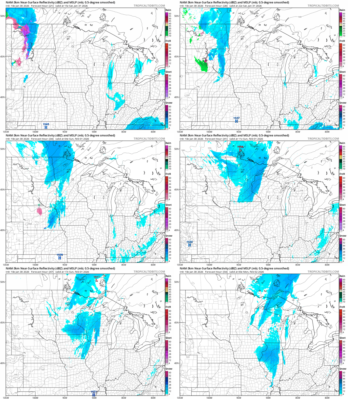
The heaviest 1 to 3 inch snow zones favors northern Minnesota. (See the map at the top of this post.)
The Twin Cities looks likely to pick up an inch or two. Roads will likely get a little slick Sunday across most of Minnesota.

Gusty winds in northwest Minnesota favor blowing snow. Here’s the National Weather Service guidance:
Including the cities of Roseau, Drayton, Hallock, Detroit Lakes, Crookston, Mahnomen, Middle River, Fargo, Thief River Falls, Breckenridge, Mayville, Newfolden, Fosston, East Grand Forks, Grand Forks, Wahpeton, Moorhead, Red Lake Falls, Halstad, Warren, Fergus Falls, Grafton, Ada, Cavalier, and Hillsboro
144 PM CST Fri Jan 30 2026
...WINTER WEATHER ADVISORY IN EFFECT FROM NOON SATURDAY TO NOON CST SUNDAY... * WHAT...Mixed precipitation and areas of blowing snow expected. Total snow accumulations between 1 and 3 inches and locally up to 4 inches. Winds gusting as high as 40 mph.
* WHERE...Portions of northwest and west central Minnesota and northeast and southeast North Dakota.
* WHEN...From noon Saturday to noon CST Sunday.
* IMPACTS...Roads, and especially bridges and overpasses, will likely become slick and hazardous. Plan on slippery road conditions. Falling and blowing snow will lead to areas of quick and sudden reductions to visibility, making travel difficult, especially in rural areas that are prone to blowing snow.
Next week looks milder than this past week with highs in the 20s. There’s still a chance of a day or two in the 30s in southern Minnesota next Thursday into Friday.

Hang in there.

