
Winter strikes back: Blizzard warning North Shore; Twin Cities accumulating snow Friday?
Two separate winter weather systems will bring snow and ice to Minnesota this week.

Go Deeper.
Create an account or log in to save stories.
Like this?
Thanks for liking this story! We have added it to a list of your favorite stories.


We’ve just lived through the warmest mid-February thaw on record for most of Minnesota. But we’re about to get a forceful reminder that it’s still February in Minnesota, and winter is not done with us yet.
Record warmth ends
Minnesota’s incredible mid-February record thaw is about to end with a return to winter. This was the warmest mid February period across most of Minnesota dating back more than 136 years. Dozens of record high temperatures were set around Minnesota the past few days. Here are just a few of note.
51 degrees - ties Twin Cities record high Friday February 13
58 degrees - breaks Canby record high Friday February 13 (previous record 57 degrees)
54 degrees - breaks Twin Cities record high Saturday February 14 (previous record 50 degrees)
43 degrees - ties record high temperature at Fargo Saturday February 14
46 degrees - ties Duluth record high Sunday February 15
46 degrees - ties International Falls high Sunday February 15
Monday’s air mass continues to produce temperatures in the 50s in southern Minnesota.
Turn Up Your Support
MPR News helps you turn down the noise and build shared understanding. Turn up your support for this public resource and keep trusted journalism accessible to all.

Just for perspective the normal high for the Twin Cities on February 16 is 29 degrees. So this air mass if running 25 degrees above normal. The record high for February 16 in the Twin Cities is 60 degrees set in 1981.
Temperatures will still be mild in the south Tuesday but 30s will be common in the north as the winter storm approaches.

Winter storm hits northern Minnesota Tuesday into Thursday
A potent winter storm is tracking for the northern half of Minnesota Tuesday night into Thursday. Winter storm and blizzard warnings are already posted in the north.
The system will track through northern Minnesota with the heaviest snow across the north. An icy mix will fall in parts of north and central Minnesota mainly Tuesday night. The Twin Cities will get some rain and maybe even some lightning and thunder Tuesday night, but most of the accumulating snow will stay north of the Twin Cities with this first system.
Here’s NOAA’s NAM 3 km model between 3 p.m. Tuesday and midnight Thursday. (Wednesday night)
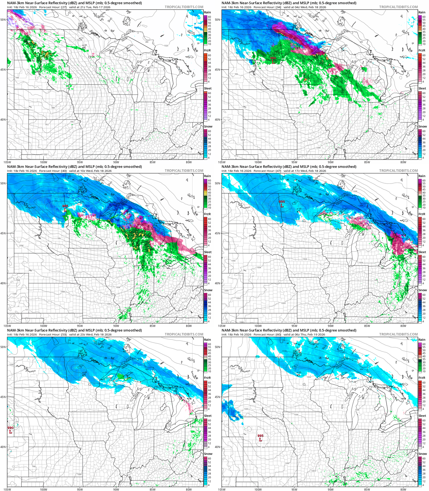
Overall snowfall accumulations will be heaviest in the north and along the North Shore where double digit snowfall is likely.

Throw in winds to 60 mph and the North Shore will have nasty blizzard conditions with this system.
Southern Lake-Southern Cook- Including the cities of Grand Marais, Two Harbors, and Silver Bay123 PM CST Mon Feb 16 2026
...BLIZZARD WARNING IN EFFECT FROM 9 PM TUESDAY TO NOON CST THURSDAY...
* WHAT...Blizzard conditions expected. Total snow accumulations between 10 and 18 inches. Easterly winds gusting as high as 60 mph.
* WHERE...Southern Cook and Southern Lake Counties. This includes the Tribal Lands of the Grand Portage Reservation.
* WHEN...From 9 PM Tuesday to noon CST Thursday.
* IMPACTS...The strong winds and weight of snow on tree limbs may down power lines and could cause sporadic power outages. Whiteout conditions are expected and will make travel treacherous and potentially life-threatening, especially along Highway 61 on the North Shore.
* ADDITIONAL DETAILS...Expect terrain enhancement to snowfall totals and snowfall rates. The heaviest snowfall rates will be Tuesday night and Wednesday morning.
Storm #2 Thursday night and Friday
The second storm this week looks likely to drop accumulating snow across southern Minnesota including the greater Twin Cities area into Wisconsin.
The European, American, and Canadian model s all have similar solutions that push a strong surface low from Missouri Thursday toward lake Superior by Saturday. At this time, the strongest bands of heavy wet snow look likely to sweep through the Twin Cities into Wisconsin Friday morning. Here’s the Canadian model output between 6 p.m. Thursday and 6 a.m. Saturday.
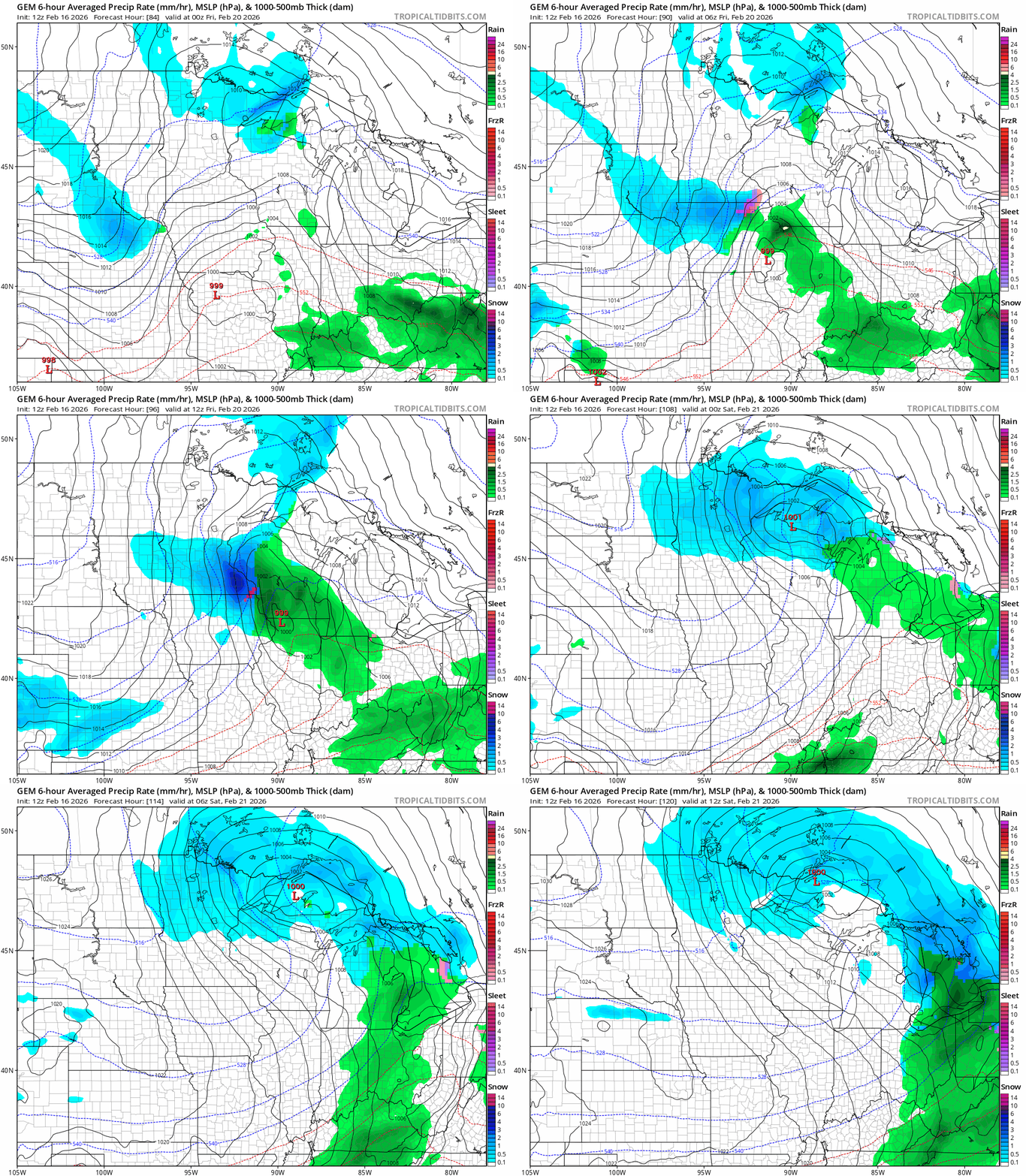
It’s still pretty early to be confident about storm track and snowfall accumulations Friday with this system. But several inches of heavy wet snow appear likely from the Twin Cities and eastern Minnesota and especially western Wisconsin with this system.
Travel could be difficult Friday in these areas.
Stay tuned as we track storm specifics this week here on Updraft and on MPR News stations that reach across Minnesota, the eastern Dakotas, northern Iowa, and western Wisconsin.

