
Winter storm, blizzard warnings up in northern Minnesota as storm bears down
North Shore likely to get 1 to 2 feet of snow, 60 mph winds

Go Deeper.
Create an account or log in to save stories.
Like this?
Thanks for liking this story! We have added it to a list of your favorite stories.


Buckle up northern Minnesota.
A major winter storm is about to deliver high winds and heavy snow to the north country. Let’s break down the system as it moves through the north into Wednesday and Thursday.
The system
This is a deep and potent low-pressure system. It will track slowly from north of Omaha, Neb., Tuesday evening to around Duluth by Thursday. It’s got plenty of wind and moisture in tow.
Colder temperatures on the north side of the system will change rain to some ice and then heavy snow across northern Minnesota overnight Tuesday into Wednesday morning.
Turn Up Your Support
MPR News helps you turn down the noise and build shared understanding. Turn up your support for this public resource and keep trusted journalism accessible to all.
The National Oceanic and Atmospheric Administration’s Global Forecast System is similar to other solutions that track the system into the north with rain changing to snow overnight and lingering into Thursday.
The forecast model loop below runs between 6 p.m. Tuesday and noon Thursday. Note the persistence of snow along the North Shore.
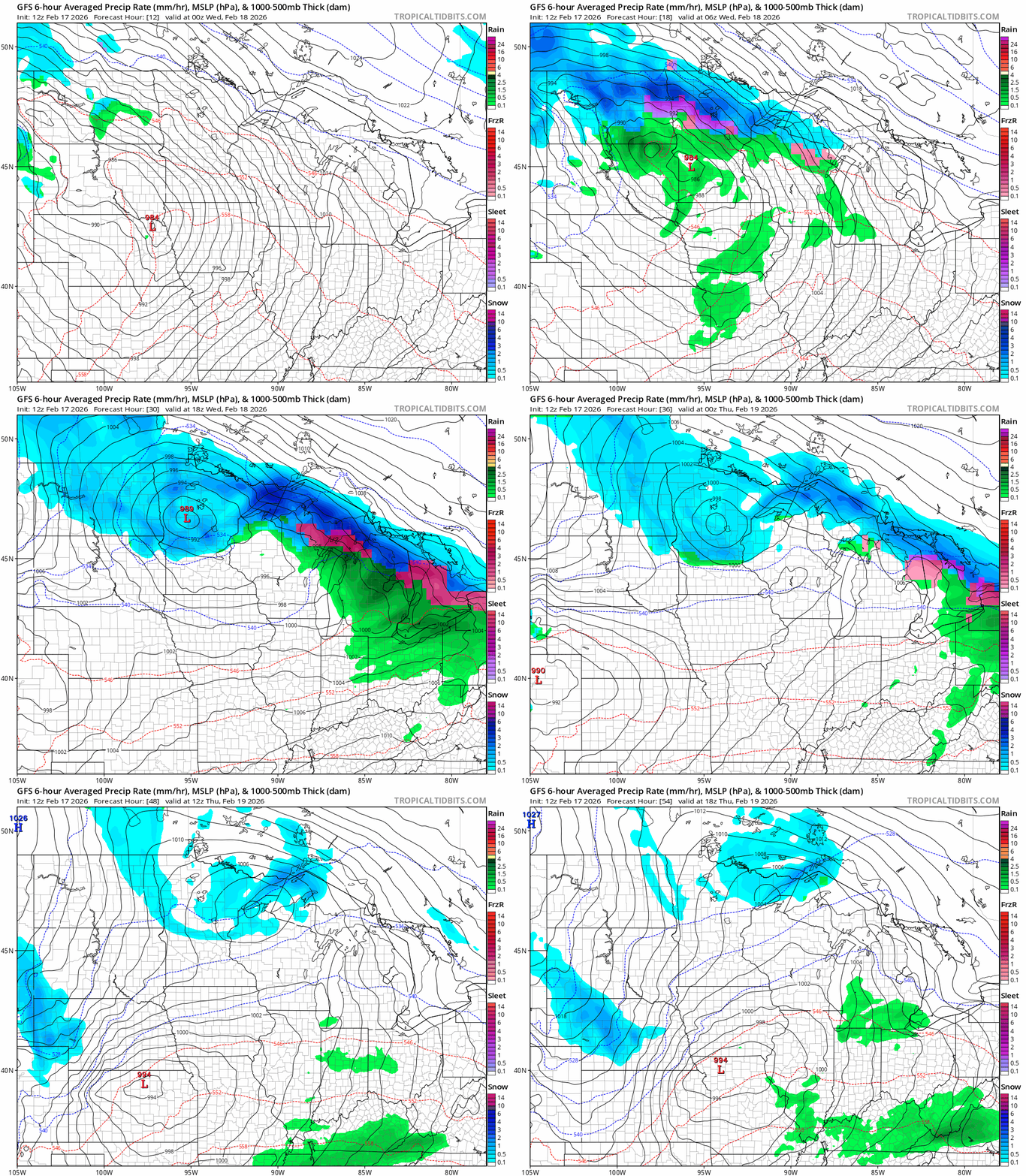
The heaviest snow will fall Wednesday across the north. Wind gusts along the North Shore will reach 40 to 60 mph!

This looks like a major shutdown blizzard along the North Shore region, which is likely to see 1 to 2 feet of snow by Thursday.

Blizzard warnings cover the North Shore form Two Harbors to the Canadian border. Here’s the National Weather Service bulletin:
Southern Lake-Southern Cook- Including the cities of Two Harbors, Silver Bay, and Grand Marais
100 PM CST Tue Feb 17 2026
...BLIZZARD WARNING REMAINS IN EFFECT FROM 9 PM THIS EVENING TO NOON CST THURSDAY...
* WHAT...Blizzard conditions expected. Total snow accumulations between 16 and 24 inches. Easterly winds gusting as high as 60 mph.
* WHERE...Southern Cook and Southern Lake Counties. This includes the Tribal Lands of the Grand Portage Reservation.
* WHEN...From 9 PM this evening to noon CST Thursday.
* IMPACTS...The strong winds and weight of snow on tree limbs may down power lines and could cause sporadic power outages. Whiteout conditions are expected and will make travel treacherous and potentially life-threatening, especially along Highway 61 on the North Shore.
* ADDITIONAL DETAILS...Expect terrain enhancement to snowfall totals and snowfall rates. The heaviest snowfall rates will be tonight and Wednesday morning.
Here’s a closer look from the National Weather Service at the winter storm warning details for the Red River Valley and much of northwestern Minnesota.
West Polk-Kittson-Roseau-Lake Of The Woods-West Marshall-East Marshall-North Beltrami-Pennington-Red Lake-East Polk-North Clearwater-South Beltrami-Towner-Cavalier-Pembina-Benson-Ramsey- Eastern Walsh-Nelson-Grand Forks-Western Walsh-
Including the cities of Michigan, Cavalier, Devils Lake, Warren, Langdon, Thief River Falls, Red Lake, Lankin, Bemidji, Drayton, Grafton, Leeds, Grand Forks, Crookston, Baudette, Bagley, Fosston, Red Lake Falls, Cando, East Grand Forks, Middle River, Hallock, Newfolden, and Roseau
1027 AM CST Tue Feb 17 2026
...WINTER STORM WARNING REMAINS IN EFFECT FROM 6 PM THIS EVENING TO MIDNIGHT CST WEDNESDAY NIGHT...
* WHAT...Heavy mixed precipitation and areas of blowing snow expected. Total snow accumulations between 5 and 10 inches with locally higher amounts. Ice accumulations of a glaze. Winds gusting as high as 40 mph.
* WHERE...Portions of north central and northwest Minnesota and northeast North Dakota.
* WHEN...From 6 PM this evening to midnight CST Wednesday Night.
* IMPACTS...Travel will be very difficult. Falling and blowing snow will lead to areas of quick and sudden reductions to visibility, making travel difficult, especially in rural areas that are prone to blowing snow. The hazardous conditions will impact the Wednesday morning and evening commutes.
Twin Cities rain, and thunder?
In the south, this system brings mostly rain overnight into early Wednesday. We may even see some lightning or hear a clap of thunder overnight across southern Minnesota, including the Twin Cities area, especially in the hours surrounding midnight.
Rain will change to snow showers in the south Wednesday as colder air pushes south. Minor accumulations are likely for the south by Thursday.

Friday system shifting eastward
The second storm system set for Friday seems to be tracking farther eastward in Tuesday forecast model runs. That would put heavier snow Friday onto Wisconsin probably just east of the Twin Cities area.
The European Centre for Medium-Range Weather Forecasts model shows the system just clipping the eastern Twin Cities Friday with a brief period of more vigorous snow. Check out the map below.
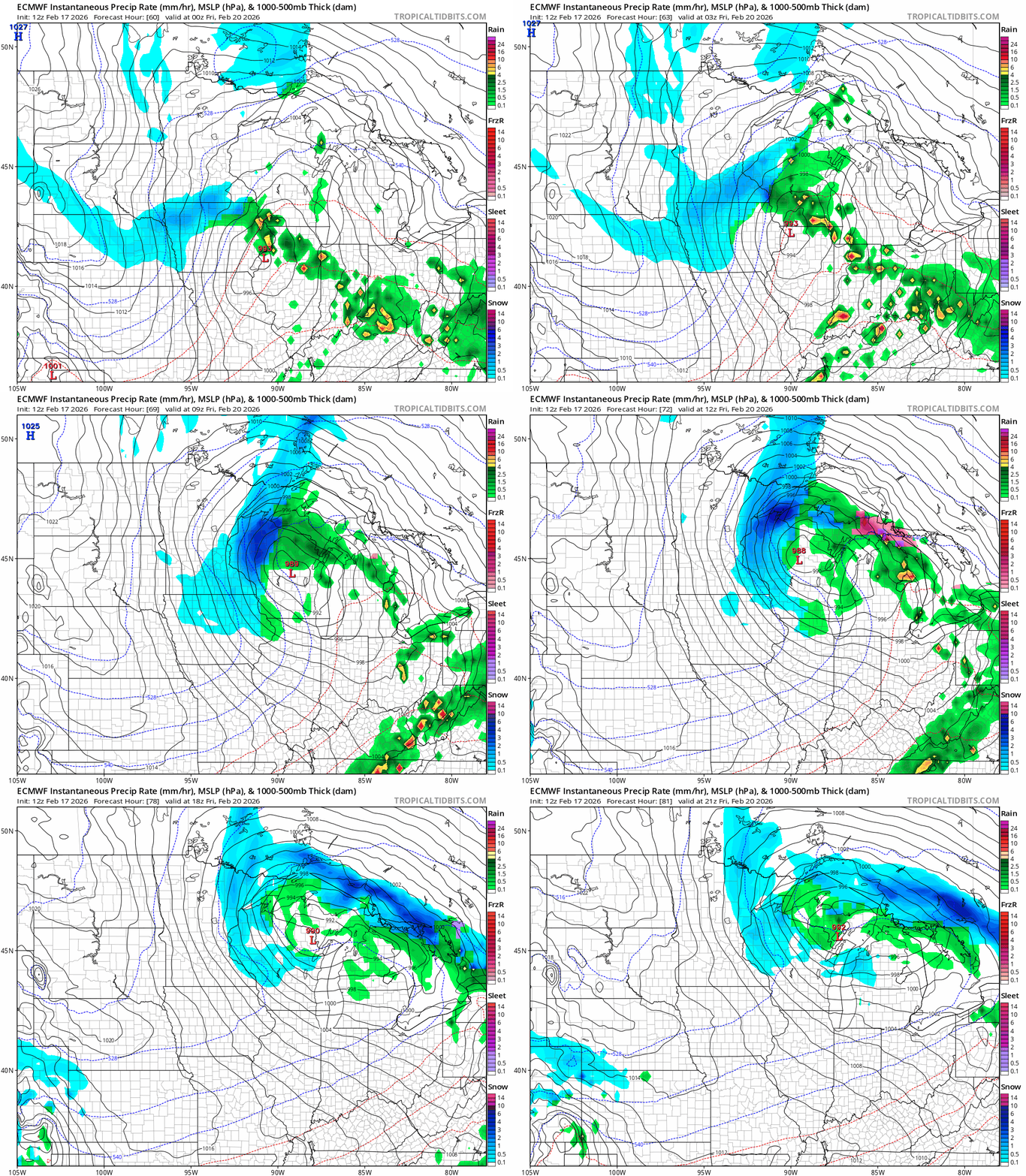
If the storm track stays east, that will put the most snow into Wisconsin Friday.
The two storms will pull down colder air that looks likely to persist into next week. It looks like February will go out on wintry notes with highs in the 20s as we move into next week.
Stay tuned.

