
North Shore blizzard rages, 19 inches so far; Twin Cities area to see accumulating snow
Thunder snow, 60 mph winds rake North Shore; slick roads, wintry mix south

Go Deeper.
Create an account or log in to save stories.
Like this?
Thanks for liking this story! We have added it to a list of your favorite stories.


One of the worst blizzards in recent memory is raking Minnesota’s North Shore region Wednesday.
More than a foot of snow has fallen already in parts of the region. And winds have gusted over 60 mph along parts of the North Shore Wednesday.
We’ve even had vivid lightning and thunder snow reports with the storm across the Northland.
Heavy snowfall totals are also coming in across much of northern Minnesota. Here are some preliminary National Weather Service snowfall reports so far Wednesday:
Turn Up Your Support
MPR News helps you turn down the noise and build shared understanding. Turn up your support for this public resource and keep trusted journalism accessible to all.
Hovland [Cook Co, MN] Cocorahs reports Snow of 19.80 Inch at 10:00 AM CST -- Additional 7.8 inches since 7AM morning observation. Still snowing heavily at observation.
5 WSW Lutsen [Cook Co, MN] Cocorahs reports Snow of 14.70 Inch at 10:00 AM CST -- Additional 7.3 inches since morning observation. Still snowing.
3 E Grand Marais [Cook Co, MN] Public reports Snow of 13.60 Inch at 11:05 AM CST -- Report is storm total. Additional 3 inches since 915 AM.
4 W Grand Marais [Cook Co, MN] Cocorahs reports Snow of 12.10 Inch at 11:00 AM CST -- Additional 5.6 inches since morning observation. Still snowing.
Chisholm [St. Louis Co, MN] Cocorahs reports Snow of 9.20 Inch at 8:59 AM CST -- Cocorahs station MN-SL-347 Chisholm 0.5 NW.
NWS Duluth [St. Louis Co, MN] Official NWS Obs reports Snow of 6.80 Inch at 12:00 PM CST -- Updates previous report. Storm total snowfall. Light snow at time of report. 0.21 inches of liquid equivalent from the snow melted down.
9 SSW Bemidji [Hubbard Co, MN] Local Official reports Snow of 6.00 Inch at 8:26 AM CST -- 4" with some pockets of 5-6".
4 S Warren [Polk Co, MN] Public reports Snow of 5.50 Inch at 6:35 AM CST --
It is still snowing heavily in many areas; snowfall totals will go higher. Blizzard warnings continue into Thursday for the North Shore. Here’s the National Weather Service bulletin:
Southern Lake-Southern Cook-Carlton and South St. Louis-
Including the cities of Silver Bay, Grand Marais, Two Harbors, and Duluth
1128 AM CST Wed Feb 18 2026
...BLIZZARD WARNING REMAINS IN EFFECT UNTIL NOON CST THURSDAY...
* WHAT...Blizzard conditions. Additional snow accumulations between 1 and 4 inches around the Twin Ports and up to 5 to 10 inches along the higher terrain of the North Shore. Ice accumulations around a light glaze. Winds gusting as high as 50 mph.
* WHERE...Carlton and South St. Louis, Southern Cook and Southern Lake Counties. This includes the Tribal Lands of the Grand Portage Reservation and the Fond du Lac Band.
* WHEN...Until noon CST Thursday.
* IMPACTS...The strong winds and weight of snow on tree limbs may down power lines and could cause sporadic power outages. Whiteout conditions are expected and will make travel treacherous and potentially life-threatening, especially along Highway 61 on the North Shore.

Twin Cities snow
I tweeted Tuesday evening that forecast models were picking up on a trend for more snow around the Twin Cities area Wednesday. That trend has panned out Wednesday.
Bands of snow are wrapping around the low-pressure center across southern Minnesota including the Twin Cities area.
The National Oceanic and Atmospheric Administration’s NAM 3 km model has been among those that wrapped bands of snow across southern Minnesota and the Twin Cities. Here’s the forecast model loop between noon Wednesday and 6 a.m. Thursday:
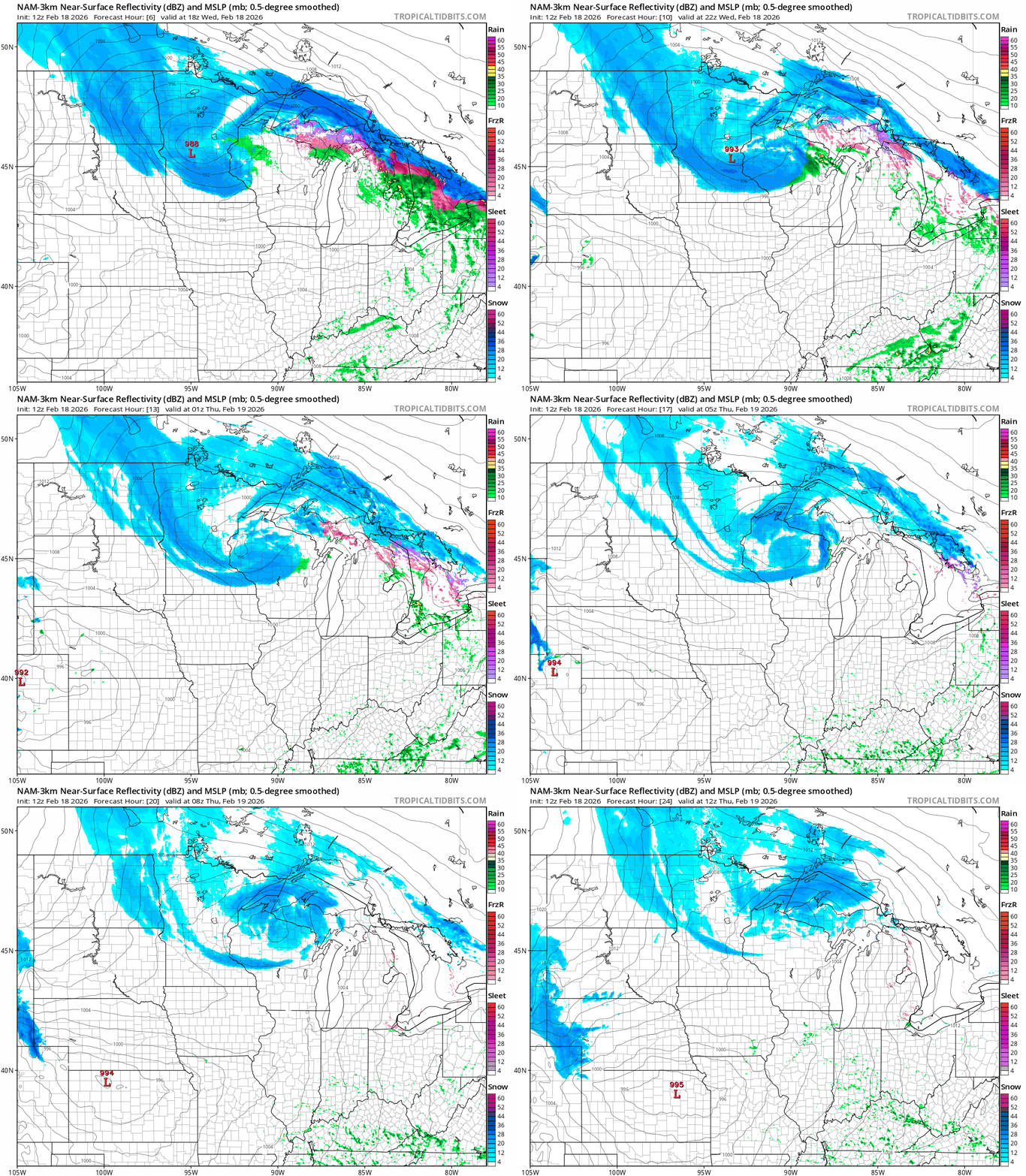
Overall, it looks like many areas in the south will pick up between 1 and 4 inches of snow through Wednesday night.

A few short-range models lay down a narrow band of up to 6 inches just south of the Twin Cities, so there could be heavier snowfall totals south of the metro area.
Temperatures have hit the freezing mark in many locations so untreated roads and walkways are slick.
It’s been a minute since we’ve had real wintry weather so take it easy out there, Minnesota!

