
Icy wintry mix overnight; spring weather returns Sunday
Icy coating topped with light snow for much of Minnesota into early Saturday

Go Deeper.
Create an account or log in to save stories.
Like this?
Thanks for liking this story! We have added it to a list of your favorite stories.


Behold the icy wintry mix.
Our messy Friday system has already produced significant ice totals in parts of northeastern Minnesota. Some areas around Duluth have picked up over an inch of icy glaze. Here’s one report:
1 E Duluth [Lsz145 Co, MN] Local Official reports Freezing Rain of 1.50 Inch at 10:45 AM CST -- 1 to 3 inches of ice accumulation from persistent freezing drizzle and riming ice on east side of Duluth Lift Bridge structure. The City of Duluth has closed the east, or lake side pedestrian walkway.
In the warm sector it’s been rain. More than an inch fell across northeastern Iowa. Austin, Minn., picked up 0.77 of an inch of rain Friday.
Farther south, a severe weather outbreak is ramping up. Tornado watches extend as far north as Ames, Iowa, thorough Friday evening.
Turn Up Your Support
MPR News helps you turn down the noise and build shared understanding. Turn up your support for this public resource and keep trusted journalism accessible to all.

Tornadoes have already been reported in southwestern Michigan Friday.
Let’s break down to messy forecast into the weekend.
The system
This hybrid wintry spring system is producing severe weather in the warm sector south of Minnesota. It’s been mostly rain and drizzle in milder eastern Minnesota. But the lingering wintry air mass is cold enough for ice and some snow on the system’s north side.
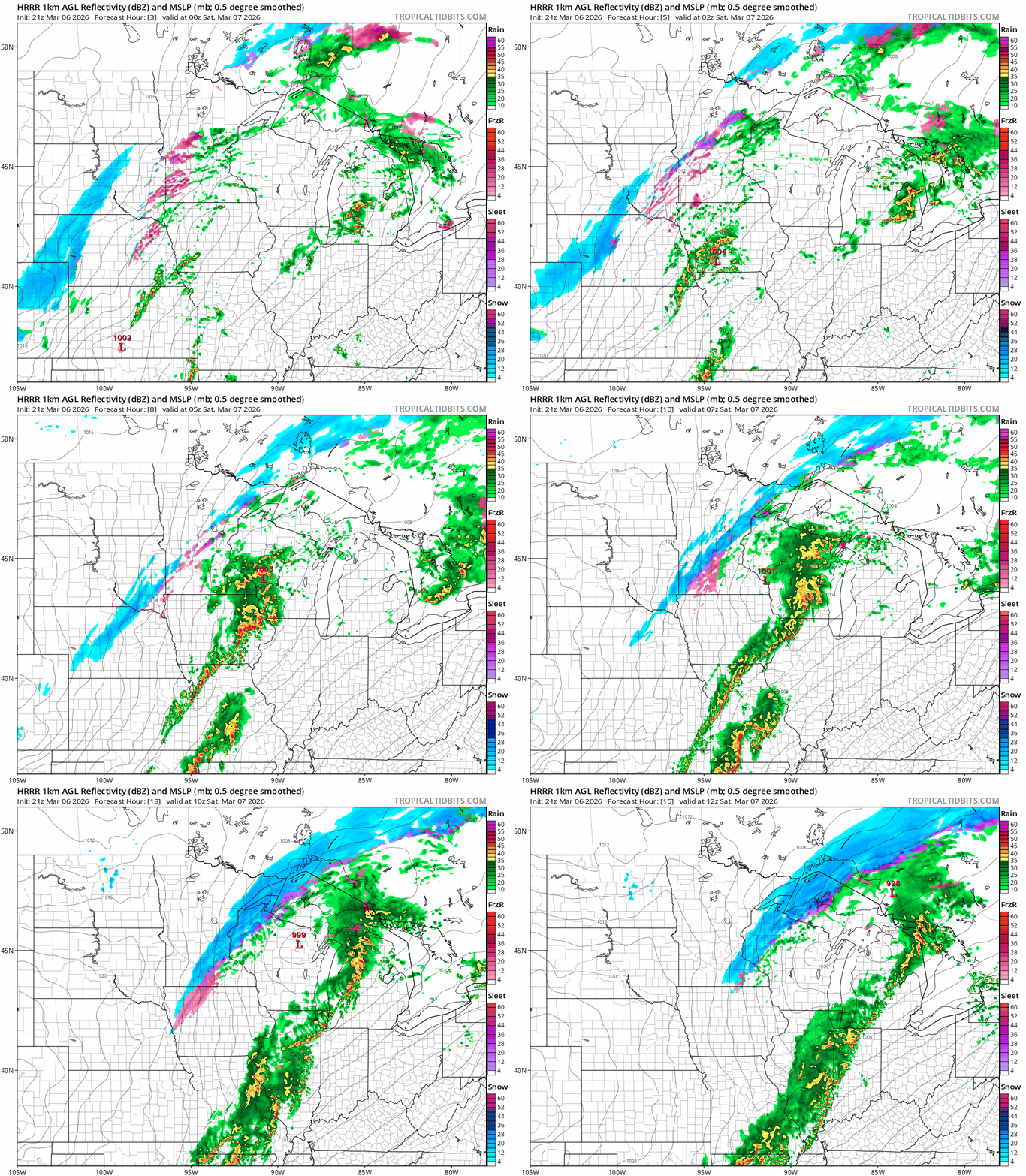
On the map below, the National Oceanic and Atmospheric Administration’s High-Resolution Rapid Refresh model shows the mix of thunderstorms south with rain changing to ice and some snow west and north overnight into Saturday.
Ice and snow
Overall ice accumulations into Saturday will reach one-tenth to two-tenths of an inch in many areas west and north of the Twin Cities. That’s not a major widespread ice storm that knocks out trees and power, but it’s enough to make untreated roads and walkways dangerously slick.

Take care out there overnight into Saturday.
A little band of snow will trail behind the ice. Snow totals look like a light coating in most areas. But with temperatures at or below freezing, it can get slick out there especially in the predawn hours Saturday morning.

Winter weather advisories cover most of the region from northeastern Minnesota all the way into the Dakotas. Here’s the advisory for northeast Minnesota:
Southern Lake-Southern Cook-Carlton and South St. Louis- Including the cities of Grand Marais, Two Harbors, Duluth, and Silver Bay
108 PM CST Fri Mar 6 2026
...WINTER WEATHER ADVISORY REMAINS IN EFFECT UNTIL 3 AM CST SATURDAY...
* WHAT...Mixed precipitation expected. Total snow accumulations up to one inch and ice accumulations around a light glaze.
* WHERE...Carlton and South St. Louis, Southern Cook and Southern Lake Counties. This includes the Tribal Lands of the Fond du Lac Band and the Grand Portage Reservation.
* WHEN...Until 3 AM CST Saturday.
* IMPACTS...Roads, and especially bridges and overpasses, will likely become slick and hazardous. Plan on slippery road conditions. The hazardous conditions could impact the Friday evening commute.
* ADDITIONAL DETAILS...For this evening, temperatures will fall below freezing in the west first and transition to below freezing eastward through the evening.
And here are the details for more of northern and central Minnesota:
Including the cities of Isabella, Brainerd, Aitkin, Walker, Ely, Hinckley, International Falls, Pine River, Bigfork, Grand Rapids, Pine City, Hibbing, and Hill City
108 PM CST Fri Mar 6 2026 ...WINTER WEATHER ADVISORY REMAINS IN EFFECT UNTIL 3 AM CST SATURDAY...
* WHAT...Mixed precipitation expected. Total snow accumulations up to one inch and ice accumulations around a light glaze.
* WHERE...Crow Wing, Aitkin, Pine, Koochiching, Cass, Itasca, Central and North St. Louis, and Northern Cook and Lake Counties. This includes the Tribal Lands of the Mille Lacs Band, East Lake, Hinckley, Lena Lake and, Big Sandy Lake areas and the Bois Forte Band, Lake Vermilion, Deer Creek and, Nett Lake areas. Other locations including Voyageurs National Park. The entire Boundary Waters is also included.
* WHEN...Until 3 AM CST Saturday.
* IMPACTS...Roads, and especially bridges and overpasses, will likely become slick and hazardous. Plan on slippery road conditions. The hazardous conditions could impact the Friday evening commute.
* ADDITIONAL DETAILS...For this evening, temperatures will fall below freezing in the west first and transition to below freezing eastward through the evening. The largest ice accumulations will be near the Brainerd Lakes area.
Conditions improve Saturday afternoon as temperatures climb above freezing.

Spring returns by Sunday
A milder westerly Pacific flow returns to Minnesota Sunday into early next week. Abundant sunshine will push highs into the 60s south Sunday afternoon with 50s well north.

It appears colder air will return once again late next week with chances for rain and or snow.
It’s still March.

