
Storm parade: High winds, heavy snow north Thursday; bigger weekend storm possible
North Shore blizzard warning Thursday; heavy snow possible south by Sunday

Go Deeper.
Create an account or log in to save stories.
Like this?
Thanks for liking this story! We have added it to a list of your favorite stories.


It’s a wintry storm parade on Minnesota’s weather maps this week. Three storm systems feature snow and high winds between Wednesday and Sunday.
Let’s break down the systems and highlight snow and wind potential for different parts of Minnesota with each one.
System No. 1
Our first weather system delivered lighter snow as expected Wednesday morning. We got off relatively easy with this one. Snowfall totals ranged between 1 and 2 inches on most of the Twin Cities. Higher snowfall totals fell to the north.
Here are some select snowfall totals recorded from Wednesday morning:
Turn Up Your Support
MPR News helps you turn down the noise and build shared understanding. Turn up your support for this public resource and keep trusted journalism accessible to all.
Twin Cities core, 1-2 inches
St. Augusta, Little Falls, Cloquet, 3 inches
Chisago City, 3.7 inches
Duluth area, 2-4 inches
Hayward, Wis., 4.8 inches
Check the National Weather Service map to find more totals.
System No. 2
The next weather system is making a beeline for the northern half of Minnesota.

The National Oceanic and Atmospheric Administration’s latest 18Z Wednesday NAM 3 km model shows the wrapped up system plowing through Minnesota Thursday. Forecast models favor mostly snow north of the Twin Cities with a mix trending to mostly rain in the south.
The forecast model loop below runs between noon Thursday and 6 a.m. Friday.
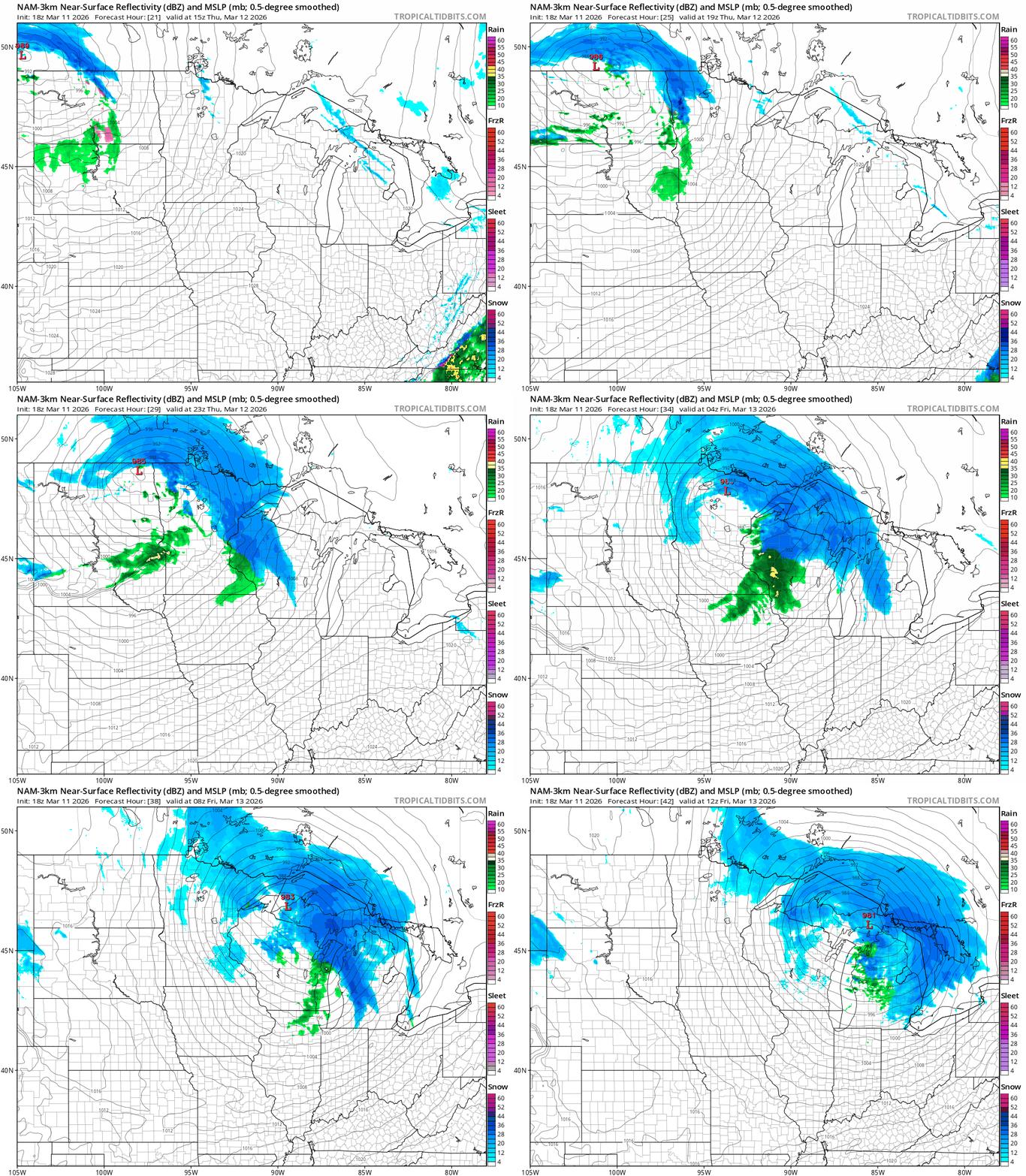
Winter storm warnings are flying in the north. Here’s the National Weather Service bulletin:
Including the cities of Isabella, Washburn, Ely, Hurley, Bayfield, Bigfork, International Falls, Superior, Hibbing, Duluth, and Ashland
1254 PM CDT Wed Mar 11 2026
...WINTER STORM WARNING IN EFFECT FROM 1 PM THURSDAY TO 1 PM CDT FRIDAY...
* WHAT...Heavy snow expected. Total snow accumulations between 4 and 8 inches except between 6 and 12 inches for northern Iron County and the higher terrain of the North Shore. Winds gusting as high as 35 mph.
* WHERE...In Minnesota, Koochiching, North Itasca, Carlton, St. Louis, and Northern Cook and Lake Counties. In Wisconsin, Ashland, Bayfield, Douglas, and Iron Counties. This includes the Tribal Lands of the Fond du Lac Band, the northwestern area of the Lac du Flambeau Band, the Red Cliff Band, the Bad River Reservation and the Bois Forte Band, Nett Lake, Deer Creek and, Lake Vermilion areas. Other locations including the Apostle Islands National Lakeshore, Madeline Island and Voyageurs National Park. The entire Boundary Waters is also included.
* WHEN...From 1 PM Thursday to 1 PM CDT Friday.
* IMPACTS...Travel could be very difficult. The hazardous conditions could impact the Thursday evening and Friday morning commutes. * ADDITIONAL DETAILS...Snowfall rates will be intense, possibly exceeding 1" per hour Thursday afternoon and evening.
Blizzard warnings are out for the North Shore once again.
Southern Lake-Southern Cook- Including the cities of Silver Bay, Two Harbors, and Grand Marais 1254 PM CDT Wed Mar 11 2026
...BLIZZARD WARNING IN EFFECT FROM 1 PM THURSDAY TO 1 PM CDT FRIDAY...
* WHAT...Blizzard conditions expected. Total snow accumulations between 6 and 13 inches. Winds gusting as high as 45 mph.
* WHERE...Southern Cook and Southern Lake Counties. This includes the Tribal Lands of the Grand Portage Reservation.
* WHEN...From 1 PM Thursday to 1 PM CDT Friday.
* IMPACTS...Visibilities will drop below 1/4 mile due to falling and blowing snow. The strong winds and weight of snow on tree limbs may down power lines and could cause sporadic power outages. Whiteout conditions are expected and will make travel treacherous and potentially life-threatening. The hazardous conditions will impact the Thursday evening and Friday morning commutes.
* ADDITIONAL DETAILS...Snowfall rates will be intense, possibly exceeding 2" per hour Thursday evening.
High wind watches and warnings are up for most of Minnesota Thursday into Friday. Winds will gust between 30 and 60 mph for Minnesota, especially Thursday night into Friday morning. Some tree branch and power line damage is possible with this storm.
Here’s the National Weather Service warning for parts of west-central Minnesota and eastern North Dakota:
Including the cities of Gwinner, Moorhead, New Rockford, Lisbon, Forman, Wahpeton, New York Mills, Valley City, Finley, Cooperstown, Fergus Falls, Breckenridge, Fargo, and Elbow Lake
149 PM CDT Wed Mar 11 2026
...HIGH WIND WARNING IN EFFECT FROM 1 PM THURSDAY TO 7 AM CDT FRIDAY...
* WHAT...West winds 30 to 40 mph with gusts up to 60 mph expected.
* WHERE...Portions of west central Minnesota and northeast and southeast North Dakota.
* WHEN...From 1 PM Thursday to 7 AM CDT Friday.
* IMPACTS...Power outages are possible. Travel will be difficult, especially for high profile vehicles.
Here’s the high wind information for southern Minnesota:
Including the cities of Minneapolis, Sauk Rapids, Monticello, Blaine, Victoria, Shakopee, Elk River, Stillwater, Chaska, Chanhassen, Hastings, Faribault, Owatonna, St Paul, Le Sueur, Little Falls, and Red Wing
1247 PM CDT Wed Mar 11 2026
...HIGH WIND WATCH IN EFFECT FROM LATE THURSDAY NIGHT THROUGH FRIDAY MORNING...
* WHAT...Northwest winds 25 to 35 mph with gusts up to 60 mph possible.
* WHERE...Benton, Morrison, Sherburne, Wright, Anoka, Carver, Dakota, Hennepin, Ramsey, Scott, Washington, Le Sueur, Rice, Steele, and Goodhue Counties.
* WHEN...From late Thursday night through Friday morning.
* IMPACTS...Damaging winds could blow down trees and power lines. Widespread power outages are possible. Travel could be difficult, especially for high profile vehicles.
It should be noted that some recent snowfall systems have suddenly tracked 50 to 100 miles farther south than models had forecast in the last 24 hours.
If that happens again, it’s possible that the Twin Cities could see more snow with this system than currently projected by forecast models.
System No. 3
The third and hopefully final wintry system arrives late Saturday through Sunday. This one looks like the biggest of the three, potentially. Forecast models crank up a textbook Colorado low with heavy snow potential and high winds.
Wednesday’s European Centre for Medium-Range Weather Forecasts model run shows the snow zone favoring the southern half of Minnesota with this system.
The usually trusty Euro puts the heaviest snow areas south of the Twin Cities along the Interstate 90 corridor at this early forecast stage.
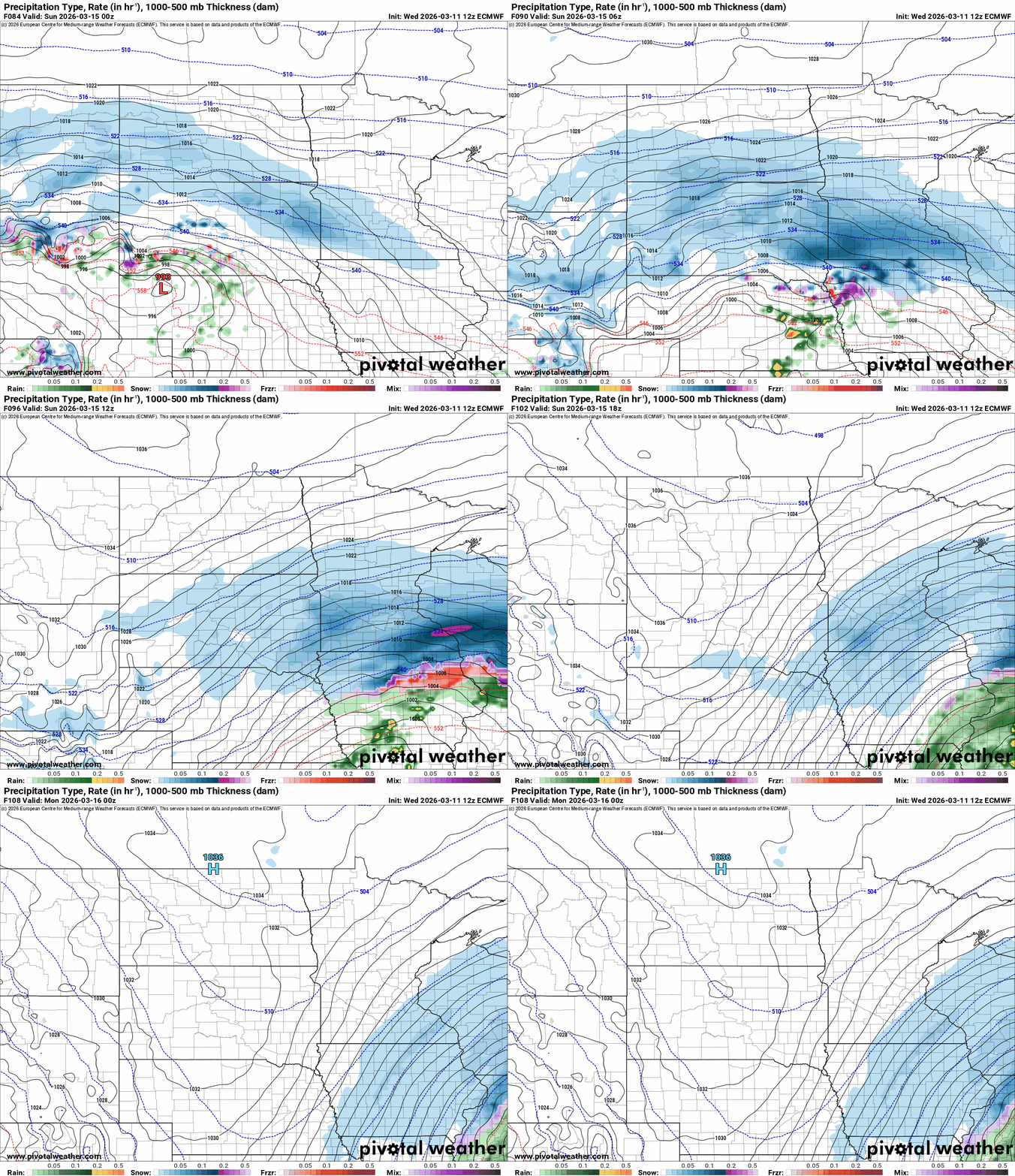
This system has the dynamics and moisture potential to produce at least 6 to 12 inches of snow in the heaviest snow zone by late Sunday.
I’ll spare you the way-too-early clickbait snowfall forecast maps four days ahead of the storm, but it should be noted that many models dump totals of more than a foot in the heaviest snow zone by Sunday night.

I’m very confident we’ll see a significant snowfall event somewhere in southern Minnesota from Saturday night through Sunday. What we can’t credibly say yet is where the heaviest snowfall axis will line up or just what precise snowfall totals look like yet.
The most actionable weather forecast at this point is to expect snow and wind Saturday night through Sunday. Travel issues are likely. This looks very plowable for much of southern Minnesota on the current forecast track.
Stay tuned.

