
High wind and blizzard warnings north into Friday; prolific snowfall totals possible south Sunday
Two severe wintry storms for Minnesota through Sunday

Go Deeper.
Create an account or log in to save stories.
Like this?
Thanks for liking this story! We have added it to a list of your favorite stories.


Batten down the hatches, Minnesota. Two separate and powerful wintry storms will bring high winds and heavy snow to different parts of Minnesota through Sunday.
We’ve got blizzard and winter storm warnings flying for the north already. And we’ll likely see winter storm watches and warnings and possibly blizzard warnings in the south as we head toward the weekend.
Never a dull weather moment this time of year in Minnesota.
Let’s break down the two powerful weather systems and what to expect through Sunday.
Turn Up Your Support
MPR News helps you turn down the noise and build shared understanding. Turn up your support for this public resource and keep trusted journalism accessible to all.
System No. 1: High winds, heavy snow north
Our first powerful storm races through Minnesota Thursday night into Friday. This tightly wrapped low-pressure storm tracks north of the Twin Cities into Friday morning.
On the map below, the National Oceanic and Atmospheric Administration’s latest 18Z High-Resolution Rapid Refresh model run shows the system laying down heavy snow in the north with a mix of mostly rain in the south, including the Twin Cities area.
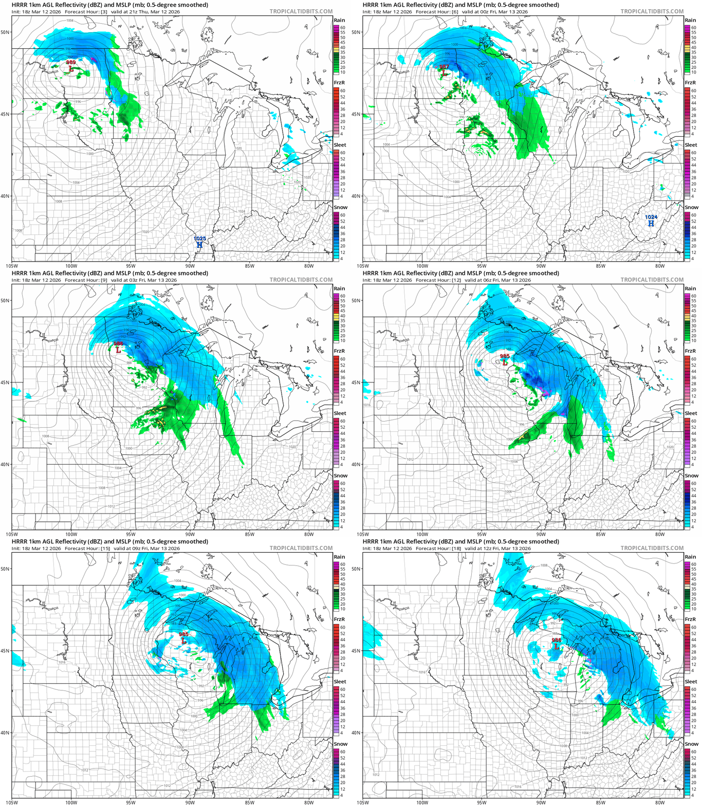
The tight pressure gradient wrapped around the low will produce severe wind gusts across most of Minnesota especially overnight into Friday morning.
This system looks like a land hurricane capable of wind gusts to near 60 mph in open areas. High wind warnings are in effect for most of Minnesota into Friday. Here’s the National Weather Service information:
Including the cities of Hastings, Little Falls, Sauk Rapids, Victoria, Blaine, St Paul, Shakopee, Faribault, Elk River, Le Sueur, Red Wing, Stillwater, Owatonna, Chaska, Monticello, Chanhassen, and Minneapolis
447 AM CDT Thu Mar 12 2026
...HIGH WIND WARNING REMAINS IN EFFECT FROM MIDNIGHT TONIGHT TO 10 AM CDT FRIDAY...
WHAT...Northwest winds 25 to 35 mph with gusts up to 60 mph expected.
* WHERE...Benton, Morrison, Sherburne, Wright, Anoka, Carver, Dakota, Hennepin, Ramsey, Scott, Washington, Le Sueur, Rice, Steele, and Goodhue Counties.
* WHEN...From midnight tonight to 10 AM CDT Friday.
* IMPACTS...Damaging winds could blow down trees and power lines. Widespread power outages are possible. Travel will be difficult, especially for high profile vehicles.

Blizzard warnings
Heavy snowfall and high winds will combine to produce blizzard conditions in the northern Red River Valley and along the North Shore. The National Weather Service reports:
Including the cities of Warren, Grafton, Lankin, Grand Forks, Langdon, East Grand Forks, and Crookston
1034 AM CDT Thu Mar 12 2026
...BLIZZARD WARNING IN EFFECT UNTIL 7 AM CDT FRIDAY...
* WHAT...Blizzard conditions expected. Total snow accumulations up to 3 inches. Winds gusting as high as 55 mph.
* WHERE...Portions of northwest Minnesota and northeast North Dakota.
* WHEN...Until 7 AM CDT Friday.
* IMPACTS...Plan on slippery road conditions. Ground blizzards create whiteout conditions that make travel extremely dangerous or impossible. The hazardous conditions could impact the Thursday evening and Friday morning commutes. Strong winds could cause tree damage.
Here are the details for Minnesota North Shore blizzard warning. High winds and snowfall of 10 to 15 inches will make travel nearly impossible:
Including the cities of Silver Bay, Two Harbors, and Grand Marais
1220 PM CDT Thu Mar 12 2026
...BLIZZARD WARNING REMAINS IN EFFECT UNTIL 1 PM CDT FRIDAY...
* WHAT...Blizzard conditions expected. Total snow accumulations between 10 and 15 inches. Winds gusting as high as 45 mph.
* WHERE...Southern Cook and Southern Lake Counties. This includes the Tribal Lands of the Grand Portage Reservation. * WHEN...Until 1 PM CDT Friday.
* IMPACTS...Visibilities will drop below 1/4 mile due to falling and blowing snow. The strong winds and weight of snow on tree limbs may down power lines and could cause sporadic power outages. Whiteout conditions are expected and will make travel treacherous and potentially life-threatening. The hazardous conditions will impact the Thursday evening and Friday morning commutes.
* ADDITIONAL DETAILS...Snowfall rates will be intense, possibly exceeding 2" per hour Thursday evening.
Winter storm warnings
Winter storm warnings cover the rest of northern Minnesota between blizzard zones. Widespread snowfall of between 4 and 10 inches is likely through Friday.
Including the cities of Bigfork, Bayfield, International Falls, Ely, Hurley, Washburn, Isabella, Superior, Ashland, and Hibbing
1220 PM CDT Thu Mar 12 2026
...WINTER STORM WARNING REMAINS IN EFFECT UNTIL 1 PM CDT FRIDAY...
* WHAT...Heavy snow expected. Total snow accumulations between 5 and 8 inches except between 10 and 13 inches for the higher terrain of the North Shore. Winds gusting as high as 45 mph.
* WHERE...In Minnesota, Koochiching, North Itasca, Central and North St. Louis, and Northern Cook and Lake Counties. In Wisconsin, Ashland, Bayfield, Douglas, and Iron Counties. This includes the Tribal Lands of the Red Cliff Band, the northwestern area of the Lac du Flambeau Band, the Bad River Reservation and the Bois Forte Band, Nett Lake, Lake Vermilion and, Deer Creek areas. Other locations including Voyageurs National Park, the Apostle Islands National Lakeshore and Madeline Island. The entire Boundary Waters is also included. * WHEN...Until 1 PM CDT Friday.
* IMPACTS...Travel could be very difficult. The hazardous conditions could impact the Thursday evening and Friday morning commutes. Gusty winds could bring down tree branches.
System No. 2: Heavy snow south Saturday night and Sunday
The second powerful storm blows into mostly southern Minnesota Saturday night through Sunday. This system is a textbook powerful Colorado low.
These systems pack the dynamics and moisture to produce heavy snowfall rates of 1 to 3 inches per hour in the peak dendritic growth snow zone. There may also be thunder snow in the severe updraft zone with this system.
Preliminary storm track
We’re still 60 to 72 hours from the evolution of this storm across southern Minnesota. So forecast models storm tracks will likely change between now and Sunday.
Keep in mind that any snowfall forecast you see through Friday will likely change if the storm track shifts even 40 miles.
Thursday’s forecast models all favor placing the heaviest snow zone south of the Twin Cities to around the Interstate 90 corridor.
The European Centre for Medium-Range Weather Forecasts model paints a relatively narrow zone for the heaviest (possibly prolific) snowfall rates. Here’s the European model output between noon Saturday and 6 p.m. Sunday:
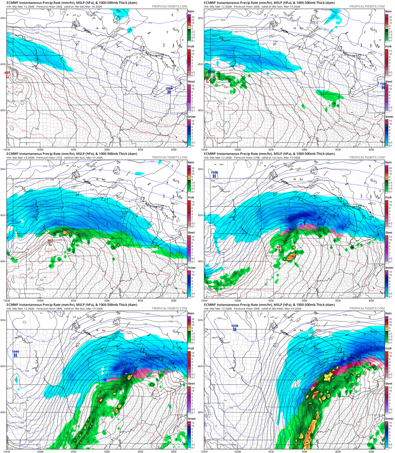
It should be noted that the Canadian model and NOAA’s Global Forecast System model suggest a wider, heavy snow zone that includes at least the southern Twin Cities.
Snowfall potential
I’ll post this European Centre for Medium-Range Weather Forecasts model 10:1 ratio snowfall output as a staring point. Right now I’m thinking there will likely be a sharp snowfall gradient from north to south across the Twin Cities.

My early read if the European model forecast track holds is we could see as little as 4 inches in the north to potentially double-digit snowfall in the southern Twin Cities by Sunday night. Obviously those numbers will be higher if the storm comes north, and lower if it shifts south.
Actionable forecast
The best travel window on the roads in southern Minnesota including the Twin Cities will be between Friday evening and about late afternoon Saturday. After that all bets are off Saturday night through Sunday in the south.
The heaviest snow will fall between midnight and about 3 p.m. Sunday especially south of the Twin Cities. Sunday looks like a good day to binge your favorite series and peek out the window to check snow totals.
Next week starts cold and wintry with more snow possible. Forecast models suggest a significant warmup late next week.
Buckle up!

