
Sunday snow blitz: Wide snowfall range, dangerous travel conditions likely across Minnesota
Extreme double-digit snowfall for some areas; icy mix possible south of Twin Cities

Go Deeper.
Create an account or log in to save stories.
Like this?
Thanks for liking this story! We have added it to a list of your favorite stories.


Buckle up, Minnesota.
We’re about 24 hours away from the onset of what looks like the worst wintry storm of the year for parts of Minnesota. This powerful storm will bring high winds, ice, and heavy snowfall to parts of central Minnesota likely including the Twin Cities are into Wisconsin.
Let’s break down the storm into the most impactful pieces as we look ahead into the upcoming weekend.
Best travel times
Let’s start with the good news before the storm hits.
Turn Up Your Support
MPR News helps you turn down the noise and build shared understanding. Turn up your support for this public resource and keep trusted journalism accessible to all.
Travel conditions will be good Friday evening through at least early afternoon Saturday for the Twin Cities and much of the region. Your best option this week weekend is to get errands done before noon or 3 p.m. Saturday.
All bets are off by Saturday evening and especially Sunday across central Minnesota, including the Twin Cities area.
The storm system
A classic, even textbook, Colorado low heads for Minnesota Saturday and Sunday.
This potent system features high end dynamics that will create strong updrafts in the heavy snow zone. That may produce thunder snow with snowfall rates of 2 to 3 inches per hour at the system’s peak Sunday morning.
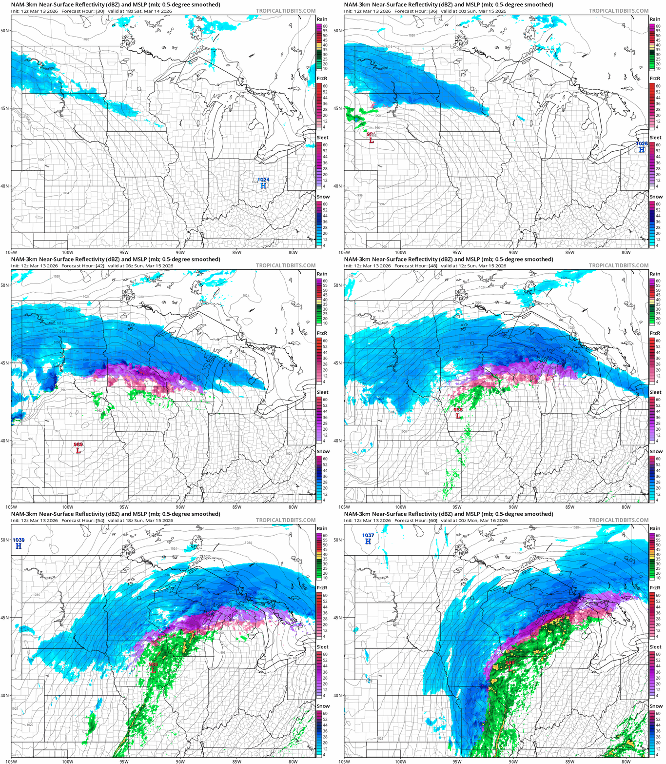
There are varying forecast models solutions, as usual. The National Oceanic and Atmospheric Administration NAM 3 km model on the map below seems to blend many features of other forecast models.
Snow begins in a sliver of western Minnesota Saturday morning and spreads east toward the Twin Cities Saturday afternoon.
The heaviest snowfall is likely between late Saturday night through midday Sunday. The forecast model loop below runs between noon Saturday and 6 p.m. Sunday. Note the pink shades showing mixed ice on the southern end of the snow zone.
Winter storm and blizzard warnings
Winter storm warnings cover most of central and southern Minnesota into Wisconsin.

Check out the extreme wording from the Twin Cities National Weather Service office on this powerful storm:
URGENT - WINTER WEATHER MESSAGE National Weather Service Twin Cities/Chanhassen MN 1213 PM CDT Fri Mar 13 2026
...POWERFUL WINTER STORM ON TRACK TO BRING EXTREME SNOW ACCUMULATIONS AND GUSTY WINDS...
...TRAVEL MAY BECOME IMPOSSIBLE LATE SATURDAY NIGHT AND SUNDAY...
.A major winter storm will move across the Upper Midwest starting late Saturday and lasting through Sunday. The first concern is heavy snow, with a broad area of 10 to 16 inches likely, and a narrow swath of 15 to 20 inches Totals across portions of western and central Wisconsin could approach 2 feet. The heaviest snow will fall Saturday evening and overnight, with rates of 2 inches per hour possible.
Winds will start out of the northeast at 20 to 30 mph. The second concern is increasing winds on Sunday. Even though the snow will be diminishing on Sunday, northwest winds will increase to 35 to 45 mph.
The combination of heavy snow and gusty winds will reduce visibility and create periods of blizzard conditions on Sunday across western and southern Minnesota. Travel is expected to become very difficult or impossible late Saturday night and Sunday. In addition, the amount of water in the snowpack will make it wet and very heavy, leading to the potential for infrastructure damage and a health hazard for those shoveling.
Here’s the warning text for the greater Twin Cities area from Twin Cities NWS office:
Including the cities of St Paul, Elk River, St Cloud, Chaska, Minneapolis, Victoria, Blaine, Chanhassen, Stillwater, and Monticello
1213 PM CDT Fri Mar 13 2026
..WINTER STORM WARNING REMAINS IN EFFECT FROM 7 PM SATURDAY TO 7 AM CDT MONDAY...
* WHAT...Heavy snow expected. Total snow accumulations between 10 and 16 inches. Winds gusting as high as 40 mph.
* WHERE...Sherburne, Stearns, Wright, Anoka, Carver, Hennepin, Ramsey, and Washington Counties.
* WHEN...From 7 PM Saturday to 7 AM CDT Monday.
* IMPACTS...Travel could be very difficult to impossible. Widespread blowing snow could significantly reduce visibility. The hazardous conditions will impact the Monday morning commute.
Blizzard warnings are up for a few counties in western Minnesota and eastern South Dakota that include the cities of Ortonville, Britton, Wheaton, Webster, and Sisseton
223 PM CDT Fri Mar 13 2026
...WINTER STORM WARNING IN EFFECT FROM 1 PM SATURDAY TO 3 AM CDT SUNDAY... ...BLIZZARD WARNING IN EFFECT FROM 3 AM TO 7 PM CDT SUNDAY...
* WHAT...For the Winter Storm Warning, heavy snow and widespread blowing snow expected. Winds gusting as high as 40 mph. For the Blizzard Warning, blizzard conditions expected. Winds gusting as high as 45 mph. Total snow accumulations for the event will be between 10 and 15 inches.
* WHERE...In Minnesota, Big Stone and Traverse Counties. In South Dakota, Day, Marshall, and Roberts Counties.
* WHEN...For the Winter Storm Warning, from 1 PM Saturday to 3 AM CDT Sunday. For the Blizzard Warning, from 3 AM to 7 PM CDT Sunday.
* IMPACTS...Travel could be very difficult. Whiteout conditions will make travel extremely dangerous or impossible. Gusty winds could bring down tree branches.
It’s possible we’ll see additional blizzard warnings issued for Sunday as high winds greater than 40 mph and heavy snow reduce visibility and make travel nearly impossible in some areas.
Ice mixing in
Forecast models suggest a warmer layer of air on the south side of the system will mix in some sleet and snow pellets. This is most likely south of the Twin Cities into the southern metro.
Areas that get a few hours of ice will see reduced snowfall totals. NOAA’s NAM model snowfall output shows this trend from the southern Twin Cities southward:

Snowfall totals
As usual, there are huge differences in eventual snowfall totals between various forecast models. There are some atmospheric reasons for this with this particular storm.

Ice mixing in to the south in spring storms can kill large dendrite formation reducing snowfall totals. This system will likely produce a relatively narrow band of the heaviest snowfall inside a wider band of less intense snow.
The most likely outcome for this system is a wide zone of between 5 and 10 inches of snow to the north and south of the heaviest 10 inch plus snowfall bands in the middle. So places from Brainerd to north of St. Cloud could fall in this lesser but still significant snow band.
The same goes for areas generally south of the Twin Cities. Here’s the European Centre for Medium-Range Weather Forecasts model (10:1 ratio) snowfall output:

The forecast models have been shifting the heaviest snow zone gradually north the past couple of days.
As of Friday afternoon, the most consensus centers around a narrower band of extreme snowfall (50 miles wide?) from east to west across central Minnesota, favoring the northern half of the Twin Cities northward.
This Canadian model (Kuchera) output is on the higher end of storm snowfall solutions:

Obviously, a 30-mile shift will change things. But the best read on the potential for this system suggest a zone of double digit snowfall between 10 and 18 inches in that zone.
If the storm delivers max potential then local snowfall totals could reach 20 inches in parts of eastern Minnesota into Wisconsin where the storm will be stronger.

We still have forecast model runs overnight Friday night into Saturday morning before the snow zone sets up, so there still could be changes in that heaviest snow zone.
The main message is travel looks nearly impossible late Saturday night through Sunday.
Stay tuned to Updraft and buckle up for what could be the biggest storm of the season for parts of Minnesota and possibly parts of the Twin Cities!

