
Keep the shovels handy: Two rain-snow systems ahead this week
Snowfall accumulations likely for much of Minnesota starting Wednesday

Go Deeper.
Create an account or log in to save stories.
Like this?
Thanks for liking this story! We have added it to a list of your favorite stories.


Get ready for a bad weather April Fool’s joke, Minnesota. Except this one may look and feel all too real starting Wednesday and heading into the upcoming first weekend of April.
Two messy weather systems are swerving toward Minnesota this week. They look quite capable of dumping several inches of slushy snow across much of Minnesota. Depending on where the rain-snow line eventually sets up, we could be shoveling in the Twin Cities.
I hope you enjoyed our spring and summerlike temperatures in southern Minnesota Monday.

Let’s break down the seemingly non-identical-twin weather systems heading for Minnesota this week.
Turn Up Your Support
MPR News helps you turn down the noise and build shared understanding. Turn up your support for this public resource and keep trusted journalism accessible to all.
System No. 1 Wednesday and Thursday
Our first weather maker this week could bring some light snow and mixed precipitation as early as Tuesday. Winter weather advisories for ice and light snow are up for most of northern Minnesota Tuesday. Here’s the National Weather Service:
Including the cities of Walker, Bayfield, Silver Bay, Hurley, Aitkin, Grand Rapids, Brainerd, Two Harbors, Pine City, Bigfork, Ashland, Superior, Hinckley, Washburn, Hill City, Duluth, and Hibbing
1109 AM CDT Mon Mar 30 2026
...WINTER WEATHER ADVISORY IN EFFECT FROM 1 AM TO 1 PM CDT TUESDAY...
* WHAT...Mixed precipitation expected. Total snow accumulations up to one inch and ice accumulations around one tenth of an inch.
* WHERE...In Minnesota, Crow Wing, Aitkin, Pine, North Cass, Itasca, Carlton, South and Central St. Louis, and Southern Lake Counties. In Wisconsin, Ashland, Bayfield, Douglas, and Iron Counties. This includes the Tribal Lands of the Fond du Lac Band, the northwestern area of the Lac du Flambeau Band, the Bad River Reservation, the Red Cliff Band, the Mille Lacs Band, Hinckley, Lena Lake, East Lake and, Big Sandy Lake areas and the Bois Forte Band, Lake Vermilion and, Deer Creek areas. Other locations including Madeline Island and the Apostle Islands National Lakeshore.
* WHEN...From 1 AM to 1 PM CDT Tuesday. * IMPACTS...Plan on slippery road conditions. The hazardous conditions could impact the Tuesday morning commute.
The best chance for frozen precipitation is north of the Twin Cities, but I can’t rule out a little mixed precipitation reaching the metro area early Tuesday. Scattered rain showers are possible Tuesday afternoon.
But the main body of the system arrives Wednesday into Thursday.
The European and Canadian models favor solutions that keep the rain snow line mostly near or just north of the Twin Cities through most of the system. That would mean rain and possibly ice mixing in around the metro region with the higher system snowfall totals to the north across central and northern Minnesota.
Here’s the European Centre for Medium-Range Weather Forecasts model output between 1 p.m. Wednesday and 7 p.m. Thursday:
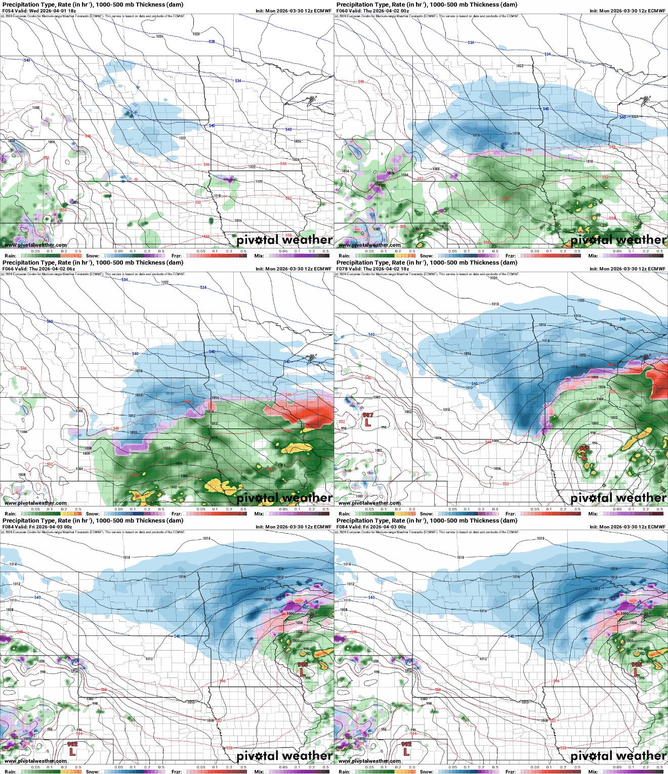
Here’s an early look at European model snowfall trends for system No. 1. This can and will likely change.

The American models are farther south with the rain-snow line, and that would bring more snow into the greater Twin Cities. It should be noted that the recent trend has been farther south with systems than models have shown leading into the last 24 hours.
System No. 2 Friday and Saturday
The second weather system rides in on the heels of our first. Early indications are this system could track slightly farther north. If so, that would mean more rain to start in the Twin Cities and southern Minnesota.
A change to snow and windy cold Saturday night into Easter morning looks likely behind the system. Here’s the Canadian model between 7 a.m. Friday and 7 a.m. Sunday:
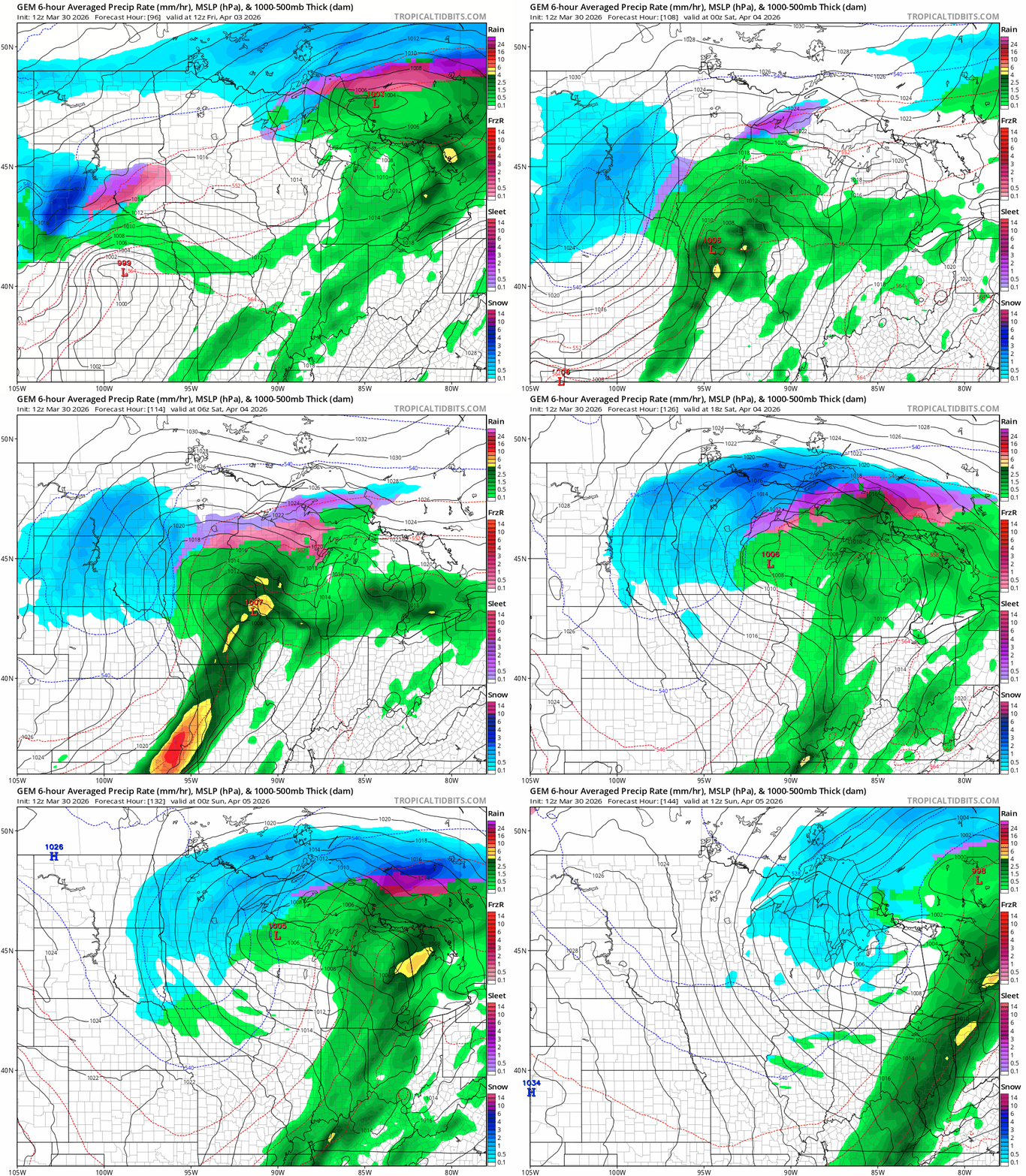
The potential for heavier snow with these two systems right now seems to strongly favor central and northern Minnesota through Saturday. There are many forecast questions regarding precipitation types around the Twin Cities, with southern Minnesota favoring mostly rain.
There is the potential for sloppy, shovelable snow around the Twin Cities with both systems.
I’m glad I kept the snow stakes in the Weather Lab driveway.
Stay tuned.

