
Winter storm watches, advisories across Minnesota Wednesday night through Thursday
Heaviest snow in Minnesota's northern half; wintry mix likely for Twin Cities

Go Deeper.
Create an account or log in to save stories.
Like this?
Thanks for liking this story! We have added it to a list of your favorite stories.


Just when you thought it was safe to start dreaming about spring.
The weather maps look increasingly busy across Minnesota as we move into April. Two weather systems will bring a messy mix of rain, ice and snow to different parts of Minnesota this week.
The heaviest snow zone favors northern Minnesota and especially the North Shore. Forecast models as of Tuesday favor a wintry mix for the Twin Cities and the south.
Let’s break down the timing and coverage of a wide variety of precipitation types and weather conditions aiming for Minnesota the next few days.
Turn Up Your Support
MPR News helps you turn down the noise and build shared understanding. Turn up your support for this public resource and keep trusted journalism accessible to all.
System No. 1 Wednesday night through Thursday
The first storm is a Colorado low that will track through Iowa Thursday. That puts Minnesota on the more wintry northern side of this system. Look for snow to spread across the northern half of Minnesota Wednesday night through Thursday.
Tuesday’s forecast models continue to favor a transition zone with a wintry mix of rain to ice and snow across much of central Minnesota, including the greater Twin Cities area.
The National Oceanic and Atmospheric Administration’s High-Resolution Rapid Refresh model seems to have a pretty good handle on the system. The forecast model run below runs between 7 p.m. Wednesday and 1 p.m. Thursday.
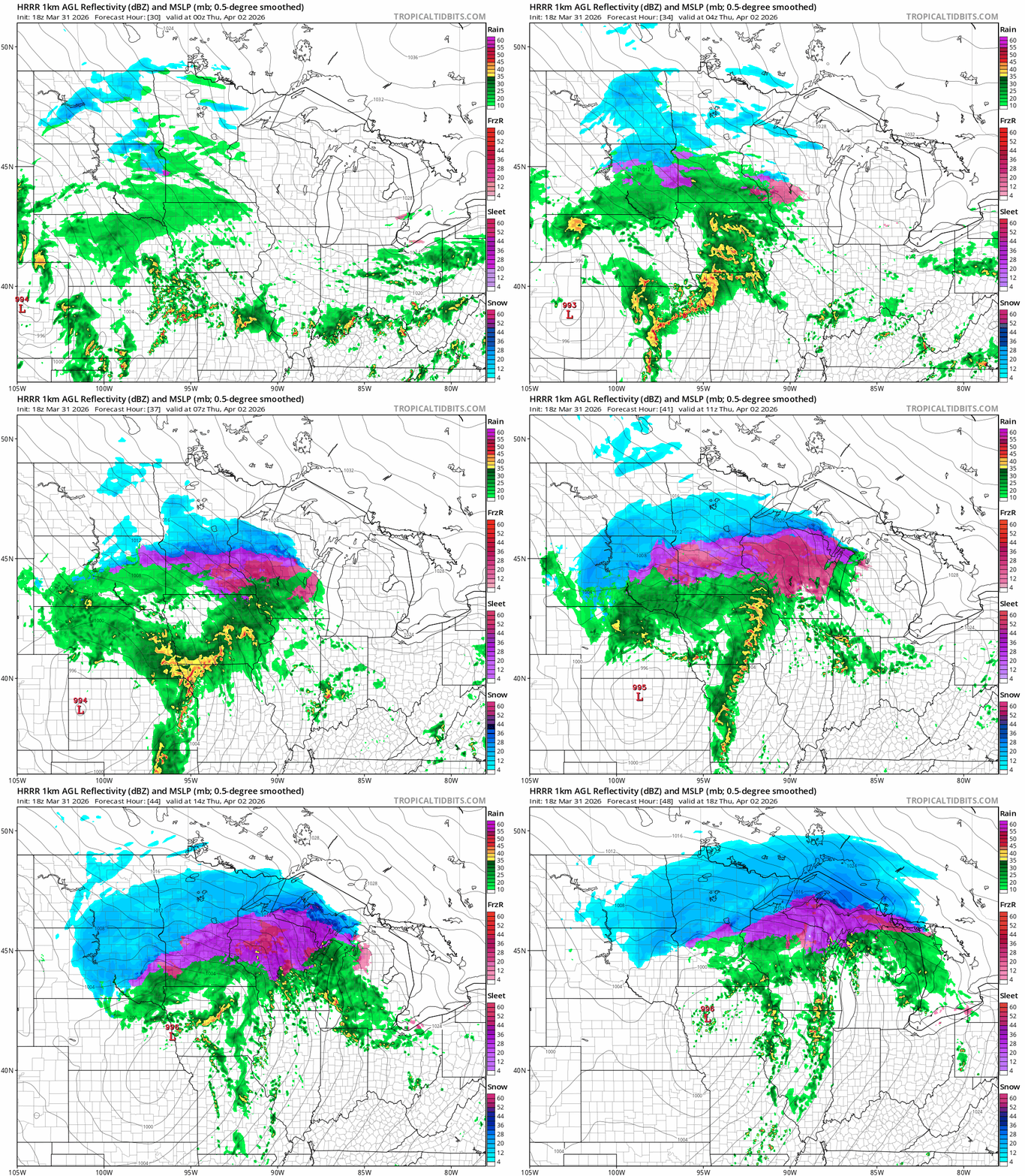
The heaviest snow and slush will be north of the Twin Cities. We could see an icy mix early Thursday morning before it warms up enough to make it mostly rain in the Twin Cities Thursday.

The sweet spot for heaviest snow favors central Minnesota through the Iron Range and especially the North Shore communities. There will be less snow as you move farther south.

Winter weather advisories cover most of southern and western Minnesota. Here’s the National Weather Service guidance:
Including the cities of Blaine, Redwood Falls, New Ulm, Hastings, Elk River, Red Wing, Olivia, Owatonna, Gaylord, Shakopee, Mankato, Chaska, Minneapolis, St Peter, St James, Center City, Hutchinson, Cambridge, Faribault, Chanhassen, Le Sueur, Stillwater, Victoria, St Paul, Monticello, and Waseca
250 PM CDT Tue Mar 31 2026 ...WINTER WEATHER ADVISORY IN EFFECT FROM 7 PM WEDNESDAY TO 7 PM CDT THURSDAY...
* WHAT...Mixed precipitation expected. Total snow accumulations up to 3 inches, sleet accumulations around 1 inch, and ice accumulations up to one tenth of an inch.
* WHERE...Portions of central, east central, south central, southeast, and southwest Minnesota.
* WHEN...From 7 PM Wednesday to 7 PM CDT Thursday.
* IMPACTS...Plan on slippery road conditions. The hazardous conditions will impact the Wednesday evening and Thursday morning commutes.
Winter storm watches will likely become warnings in the northeastern parts of Minnesota.
Including the cities of Isabella, Hinckley, Hibbing, Pine City, Bayfield, Hurley, Washburn, Duluth, Silver Bay, Two Harbors, Grand Marais, Superior, and Ashland
224 PM CDT Tue Mar 31 2026 ...WINTER STORM WATCH IN EFFECT FROM WEDNESDAY EVENING THROUGH LATE THURSDAY NIGHT...
* WHAT...Heavy mixed precipitation possible. Total snow and sleet accumulations between 4 and 9 inches except between 7 and 10 inches for the higher terrain of the North Shore and ice accumulations around one tenth of an inch possible. Winds could gust as high as 35 mph.
* WHERE...In Minnesota, Pine, Carlton, South and Central St. Louis, Cook and Lake Counties. In Wisconsin, Ashland, Bayfield, Douglas, and Iron Counties. This includes the Tribal Lands of the Red Cliff Band, the Bois Forte Band, Lake Vermilion area, the Fond du Lac Band, the Grand Portage Reservation, the Bad River Reservation, the northwestern area of the Lac du Flambeau Band and the Mille Lacs Band, Hinckley and, Lena Lake areas. Other locations including the Apostle Islands National Lakeshore and Madeline Island. This also includes the Boundary Waters eastern and central area.
* WHEN...From Wednesday evening through late Thursday night.
* IMPACTS...Travel could be very difficult. The hazardous conditions could impact the Thursday morning and evening commutes.
System No. 2 Friday night and Saturday
Our second weather system looks fairly similar to our first storm. A mix of rain south changes to wet snow in the north. The Canadian model forecast below runs between 7 a.m. Friday and 7 p.m. Saturday.
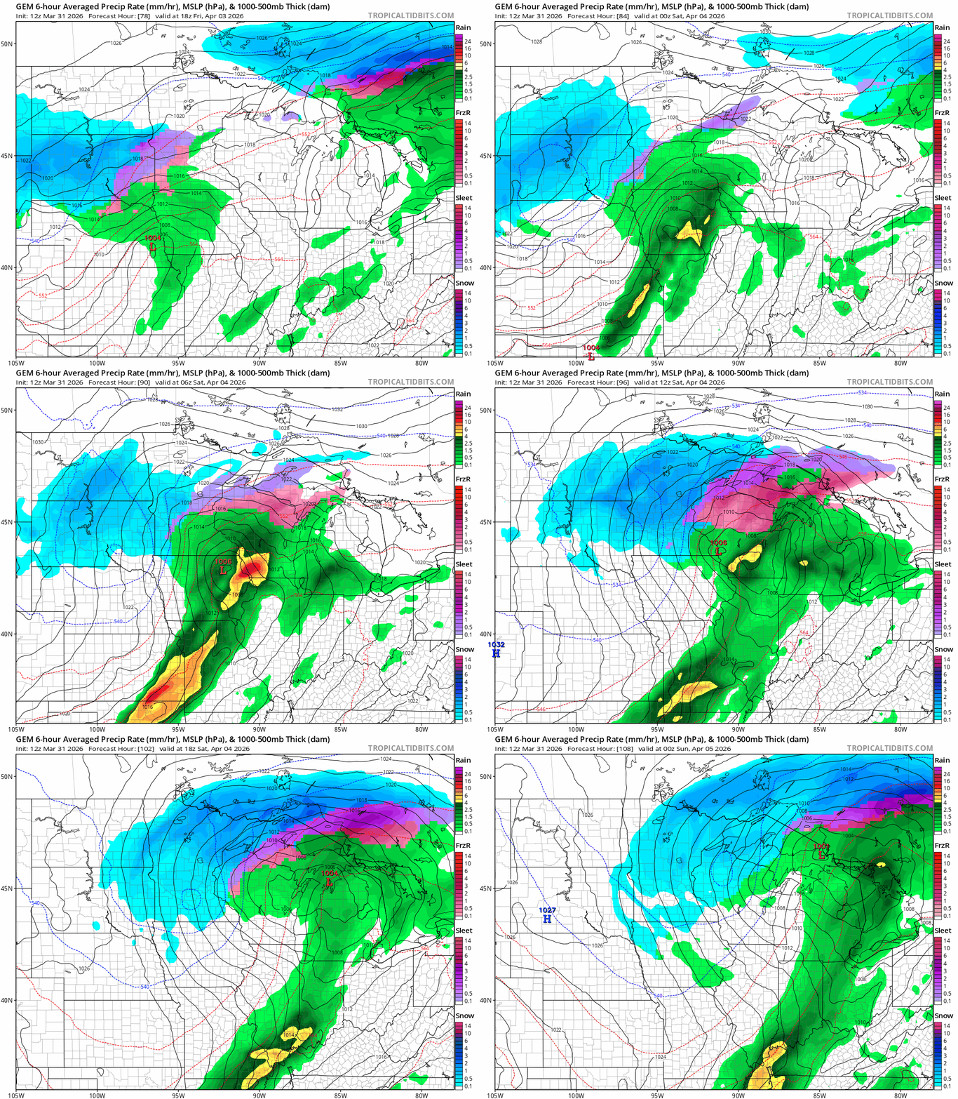
The bottom line is snow will be heaviest from central into northeastern Minnesota with both systems. The North Shore has the potential for over a foot of snow late Saturday.
We still have Wednesday’s model runs to see if there are track changes.
Stay tuned.

