
More snow north: Winter storm warnings cover northern Minnesota
6-8 inches already for northern Minnesota; another 5-10 inches through Saturday

Go Deeper.
Create an account or log in to save stories.
Like this?
Thanks for liking this story! We have added it to a list of your favorite stories.


Here we go again northern Minnesota.
Our second storm of the week moves in with more snow Friday night through Saturday. It’s more wet snow in the north. It’s mostly rain with even a little thunder possible in the Twin Cities and the south.
Our first system has already dropped a swath of heavy wet snow in the north. Here are some select snowfall totals from across northern Minnesota, measured in inches:
Fargo-Moorhead area, 3.5
Thief River Falls, 8
Bemidji area, 6 to 7
Hackensack, 7
Cohasset, 6.6
Southern Duluth area, 7.7
Finland, 8

Let’s break down the next system as we ride through Saturday.
Turn Up Your Support
MPR News helps you turn down the noise and build shared understanding. Turn up your support for this public resource and keep trusted journalism accessible to all.
The system
Another moisture-rich low-pressure system tracks from Iowa to near Chicago Saturday. It’s a cold rain in the south, but another zone of moderate to at times heavy snow will crawl across central and especially northern Minnesota Friday night through Saturday.
The National Oceanic and Atmospheric Administration’s NAM 3 km model shows the trend between 7 p.m. Friday and 7 p.m. Saturday:
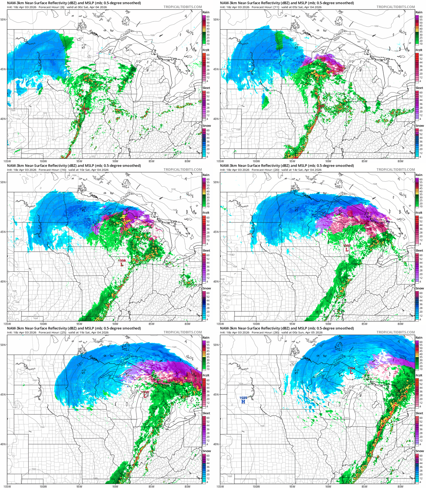
The heaviest snowfall zone favors northern Minnesota once again. (See the map at the top of the post.) Less snow will fall as you move south through a zone from Willmar through St. Cloud and Hinckley.

It’s mostly rain from the Twin Cities south. We could even have a few rumbles of thunder overnight into early Saturday especially south of the Twin Cities.
Winter storm warnings
Winter storm warnings are in effect for most of northern Minnesota. Here are the National Weather Service details for northwestern Minnesota:
Including the cities of Bemidji, Lake Itasca, Fosston, Red Lake, Roseau, Red Lake Falls, Thief River Falls, Newfolden, Two Inlets, Fergus Falls, New York Mills, Bagley, Detroit Lakes, Wadena, Park Rapids, Mahnomen, Baudette, and Middle River
1013 AM CDT Fri Apr 3 2026
...WINTER STORM WARNING NOW IN EFFECT FROM 7 PM THIS EVENING TO 1 AM CDT SUNDAY...
* WHAT...Heavy snow expected. Total snow accumulations between 5 and 12 inches.
* WHERE...Portions of central, north central, northwest, and west central Minnesota.
* WHEN...From 7 PM this evening to 1 AM CDT Sunday. * IMPACTS...Travel will be very difficult to impossible.
Here are the details for northeastern Minnesota:
Including the cities of Isabella, Ely, International Falls, Walker, Grand Rapids, Hibbing, and Bigfork
1258 PM CDT Fri Apr 3 2026
...WINTER STORM WARNING NOW IN EFFECT FROM 7 PM THIS EVENING TO 1 AM CDT SUNDAY...
* WHAT...Heavy snow expected. Total snow accumulations between 5 and 12 inches. Winds gusting as high as 35 mph.
* WHERE...Koochiching, North Cass, Itasca, Central and North St. Louis, and Northern Cook and Lake Counties. This includes the Tribal Lands of the Bois Forte Band, Deer Creek, Nett Lake and, Lake Vermilion areas. Other locations including Voyageurs National Park. The entire Boundary Waters is also included.
* WHEN...From 7 PM this evening to 1 AM CDT Sunday.
* IMPACTS...Travel could be very difficult.
Ice storm warning
It’s an ice storm warning for northwestern Wisconsin with this system.
Glaze ice of one-half inch or more could bring down branches and power lines once again. Here’s the National Weather Service guidance:
Including the cities of Grantsburg, Hayward, Hurley, Bayfield, Ashland, Phillips, Washburn, Spooner, and Superior
1258 PM CDT Fri Apr 3 2026
...ICE STORM WARNING NOW IN EFFECT FROM 7 PM THIS EVENING TO 10 AM CDT SATURDAY...
* WHAT...Significant icing expected. Total snow and sleet accumulations up to two inches and ice accumulations up to one half of an inch.
* WHERE...Price, Ashland, Bayfield, Burnett, Douglas, Iron, Sawyer, and Washburn Counties. This includes the Tribal Lands of the Red Cliff Band, the Bad River Reservation, the Lac Courte Oreilles Reservation, the St. Croix Band in Burnett County and the northwestern area of the Lac du Flambeau Band. Other locations including the Apostle Islands National Lakeshore and Madeline Island.
* WHEN...From 7 PM this evening to 10 AM CDT Saturday.
* IMPACTS...Power outages and tree damage are likely due to the ice. Travel could be nearly impossible.
* ADDITIONAL DETAILS...The majority of ice accumulations will be Friday evening and Friday night.
Mellow Easter
The sun should come out Easter Sunday across most of Minnesota. Highs in the 40s will feel nice compared to the last few days.

Next week looks milder by Wednesday. Schedule your outdoor activities then if you can.

Hang in there, Minnesota. April gets better, eventually.

