
A bridge too far
Go Deeper.
Create an account or log in to save stories.
Like this?
Thanks for liking this story! We have added it to a list of your favorite stories.


Teams from the Federal Emergency Management Agency and the state's emergency management division continue to assess the flood damage, MPR's Tim Nelson is reporting this afternoon.
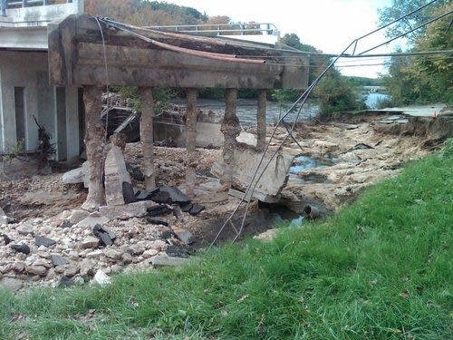
This is the iconic image of the still-unfolding disaster:
That's not going to buff out.
The close-up photos of the bridge adjacent to the Lake Shady dam in Oronoco have been posted to the Facebook page of Minnesota's Homeland Security Emergency Management agency. There is also an album of pictures from the Civil Air Patrol of Highway 169 in the St. Peter area.
Turn Up Your Support
MPR News helps you turn down the noise and build shared understanding. Turn up your support for this public resource and keep trusted journalism accessible to all.

