Steamy to stormy: Another active weather week ahead
Welcome to the sweet spot of summer in Minnesota. Blue skies. Balmy breezes. Warm lakes.
Last weekend goes in the books as one of the best in a summer that's provided an abundance of good weekend weather. We start the week with another spectacular weather day today. You'll be reaching for the AC switch tomorrow, as "moisture advection" pumps dew points toward the 70-degree mark and temperatures edge toward 90 by late afternoon across southern Minnesota.
A stalled frontal boundary drapes across the Twin Cities by midweek. The front serves as focal point for more rounds of heavy nocturnal thunderstorms, especially Wednesday night into Thursday morning. We may be counting rainfall by the inch again across central Minnesota this week.

Heat builds
Create a More Connected Minnesota
MPR News is your trusted resource for the news you need. With your support, MPR News brings accessible, courageous journalism and authentic conversation to everyone - free of paywalls and barriers. Your gift makes a difference.
We have a shot at adding to the 12 days of 90-plus heat in the Twin Cities this week. Temperatures rise into warm but still comfy mid 80s this afternoon across southern Minnesota. The heat dome builds tomorrow and Wednesday, as temps make a run at the 90 degree mark in the Twin Cities and southern Minnesota.
Looking for even more summer heat? I hear Pierre, S.D., is lovely this time of year.

Stalled hot front
The leading edge of hot sticky air mass stalls over Minnesota this week. Showers and thunderstorms increase along and north of the frontal boundary.

The best chance for heavy downpours in the Twin Cities arrives Thursday morning. The weekend looks cooler and comfortable once again before another heat spike next week. Good timing.

Flash flood potential?
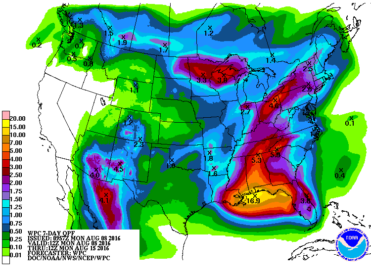
I'm already a little concerned about the potential for heavy rainfall and flash flooding later this week. The setup is ripe for slow moving, 'training' storms that can dump excessive rainfall over central Minnesota by Wednesday night. The National Oceanic and Atmospheric Administration's rainfall guidance cranks out a 3 inches-plus rainfall bull's-eye from Brainerd to Duluth and Mille Lacs once again. That could be conservative.
Hurricane's worth of rain along Gulf Coast
Note the nearly 17-inch rainfall hot spot along the Gulf Coast on the map above. It doesn't have a name, but the stalled storm along the Gulf Coast this week looks ready to dump a hurricane's worth of rainfall anywhere between New Orleans and Tampa, Fla.
Local National Weather Service offices along the Gulf Coast have been sounding the alarm for potential 10 inches-plus rainfall totals for the past few days.

Stay tuned.