Two severe storm waves likely in Minnesota Tuesday and Wednesday

Possible damaging "bow echo" signatures suggested by forecast models
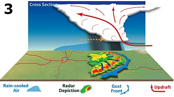
Bow echo
Bow echo
NOAA

We’re on severe weather watch in the MPR Weather Lab through Wednesday.

Our steamy tropical air mass has all the ingredients to spawn severe storms across the Upper Midwest tonight and Wednesday.

Temperatures peak Wednesday in our overheated air mass with highs into the 90s once again.

Forecast high temperatures Wednesday
NOAA

Dew points in the upper 60s to low 70s will provide fuel for storm cells to ascend rapidly, and generate heavy rains and large hail.

Create a More Connected Minnesota

MPR News is your trusted resource for the news you need. With your support, MPR News brings accessible, courageous journalism and authentic conversation to everyone - free of paywalls and barriers. Your gift makes a difference.

Two storm waves

It appears likely that two separate storm waves will cross the Upper Midwest tonight and Wednesday.

The first wave fires across western North Dakota tonight, then races east into the Red River Valley and northern Minnesota early Wednesday morning. The severe risk is highest in these areas through Wednesday morning.

Here's the Tuesday afternoon severe weather risk update from the Grand Forks NWS office.

Severe weather risk areas
Severe weather risk areas through Wednesday morning
Grand Forks NWS Office

NOAA’s NAM 3 km resolution model shows the likely storm evolution scenario between 10 pm tonight and 11 am Wednesday. A squall line may race into the Red River Valley in the wee hours Wednesday morning.

NOAA NAM 3 km model
NOAA NAM 3 km resolution model 10 pm Tuesday to 11 am Wednesday
NOAA via tropical tidbits

Wave #2: Twin Cities late Wednesday

There may be a lull in storm activity during the midday hours Wednesday. Then the risk for severe storms shifts to central and eastern Minnesota Wednesday afternoon and evening.

Severe weather risk areas Wednesday afternoon
Severe weather risk areas Wednesday
Twin Cities National Weather Service

One factor to note is the deep tropical moisture within the steamy air mass. Dew points in the 70s are likely across much of southern and central Minnesota ahead of the approaching low-pressure wave.

Dew point forecast for noon Wednesday
NOAA via tropical tidbits

As heat and humidity build and a weak low-pressure center approaches, the second wave of storms blows up in western Minnesota Wednesday afternoon. This wave has the potential to intensify and move through the Twin Cities area late Wednesday afternoon.

Forecast model storm timing may change by tomorrow, but right now many model favor a strong to severe line of storms blowing through the Twin Cities between 5 and 8 pm Wednesday.

NOAA NAM 3 km model Wednesday
NOAA NAM 3 km model 3 pm to 10 pm Wednesday
NOAA via tropical tidbits

Bow echoes?

This type of weather pattern favors the development of squall lines. On radar, these lines can surge and appear as bowing line segments, or bow echoes.

Bow echo evolution
Bow echo evolution
NOAA

Bow echoes are notorious for damaging wind events. Wind can reach 70 mph or greater in many bow echo events. Large hail between 1 and 2 inches in diameter is also often generated by stronger storms.

Expect severe weather watches across North Dakota east into the Red River Valley and northern Minnesota Tuesday night into Wednesday morning.

Wednesday’s severe focus shifts to central and eastern Minnesota where watches and severe weather warnings look likely Wednesday afternoon and evening.

Stay situationally aware through Wednesday across the Upper Midwest.