La Niña advisory issued; snowy winter ahead for Minnesota?

La Niña events statistically favor rigorous winters for Minnesota

Tropical Pacific SST departures from average
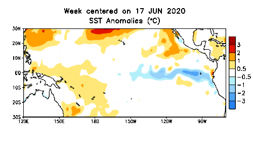
Tropical Pacific SST departures from average show a cooling trend (blue shades) in the tropical Pacific Ocean.
NOAA

It’s official. La Niña is here.

More specifically, La Niña conditions now exist in the tropical Pacific Ocean. That means sea surface temperatures in the equatorial Pacific are running cooler than average across a large region.

Pacific Ocean temperature departure in August 2020
Pacific Ocean temperature from average departure in August 2020
NOAA

The National Oceanic and Atmospheric Administration has issued a La Niña advisory.

La Niña—the cool phase of the El Niño-Southern Oscillation climate pattern—emerged in the tropical Pacific in August 2020. Forecasters estimate a 75% chance these conditions will last through Northern Hemisphere winter.

La Niña impacts in Minnesota

I recently wrote about the statistical significance of La Niña winters in Minnesota. Climatologically, La Niña winters skew colder and snowier than average.

Create a More Connected Minnesota

MPR News is your trusted resource for the news you need. With your support, MPR News brings accessible, courageous journalism and authentic conversation to everyone - free of paywalls and barriers. Your gift makes a difference.

Typical La Nina winter pattern
NOAA

Right now, NOAA’s three-month temperature outlook for meteorological winter (December-February) favors equal chances for warmer and colder than average temperatures this winter across Minnesota.

Winter temperature outlook
NOAA

NOAA’s precipitation outlook favors above-average precipitation from December through February.

Winter precipitation outlook
NOAA

Minnesota winters have warmed about 5 degrees on average since 1970 due to climate change. Keep in mind that even though our winters are considerably milder on average, it’s still below freezing and cold enough for snow most of the winter.

If this winter brings a typical La Niña pattern, we could see more than our fair share of snowfall this winter.

Here’s a look at average annual snowfall across Minnesota between 1981 and 2010. It ranges from around 30 inches in western Minnesota, to over 90 inches on the ridges above the North Shore.

30-year average annual snowfall in Minnesota
Minnesota DNR Climate Working Group

The 30-year annual snowfall average in the Twin Cities is 54.4 inches.

Stay tuned.