
Record-breaking early November warmth continues this week
Highs in the 70s again later this week.

Go Deeper.
Create an account or log in to save stories.
Like this?
Thanks for liking this story! We have added it to a list of your favorite stories.


Welcome to one more summery blast in Minnesota this November.
Highs surged into the 70s across much of Minnesota Monday. Redwood Falls hit 80 degrees. Madison hit 81 degrees.
Records fall
As I wrote earlier today, this was the warmest Election Day on record in the Twin Cities. Tuesday also broke the daily record for the warmest November 3 in the Twin Cities
Turn Up Your Support
MPR News helps you turn down the noise and build shared understanding. Turn up your support for this public resource and keep trusted journalism accessible to all.
Here’s a good summary of historical Election Day Weather in Minnesota from the Minnesota DNR Climate Working Group.
Not surprisingly, Minnesotans have endured the full range of early November weather on Election Day. We've had cool weather, warm weather, downpours, thunderstorms, fog, sleet, snow, and bright blue skies.
Going back to 1892, the presidential election weather in the Twin Cities has included a low of 9 degrees F in 1932, a high of 71 degrees F in 2008, 1.51 inches of precipitation in 1932, and 1.2 inches of snow in both 1992 and 2000. The snow in 1992 came on the tail end of a large, multi-day snowstorm that brought six inches or more to most of Minnesota, with over 9 inches in the Twin Cities, and over a foot in Waseca, Cambridge, Collegeville, Duluth, and International Falls. Despite the inclement weather, voter turnout reported by the Secretary of State in 1992 was 73.9%--higher than any year since 1968 and until 2004. The next presidential election in 1996 had much less hazardous weather--temperatures were above freezing, with no snow on the ground--yet turnout was only around 67 percent.
On average, Election Day high temperatures range from near 40 degrees F in International Falls, to 49 degrees in the Twin Cities, with lows ranging from the 20s F in northern Minnesota, to the 34 F in the Twin Cities. The tables below show the historical weather in the Twin Cities for presidential electiona back to 1892, and for mid-term election (held every four years, in the middle of the presidential term), back to 1910.
Warm spell continues
Our record November warm spell continues this week. Highs will reach the 70s across much of Minnesota on Wednesday, Friday, and Saturday.
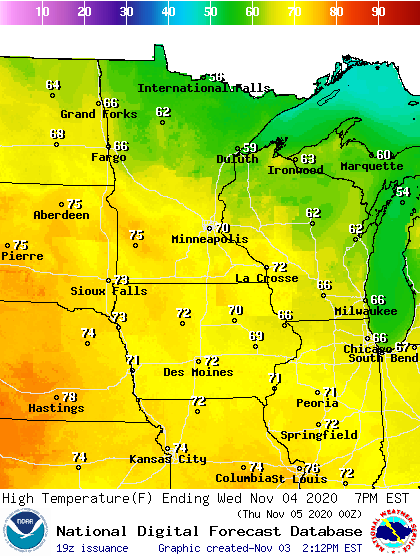
One forecast note. Forecast models often underestimate unseasonable forecast extremes like we are seeing this week. The numbers above are probably 2 to 5 degrees conservative for Wednesday and later this week.

