Half of Minnesota is now in extreme drought, but rain is on the way

Storms Friday include a widespread risk for severe weather
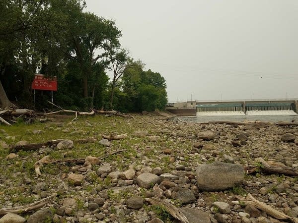
Rocks exposed by low water along a river
More of the bed of the Mississippi River is exposed below the Coon Rapids Dam in Coon Rapids, Minn., on July 29.
Emily Bright | MPR News file

Hot and dry weather continues to deepen Minnesota’s drought situation. A pattern change could make a dent in the drought over the next week, starting with a potent storm that hits the state Friday.

With Minnesota seeing little rain in the past week, plus temperatures turning hotter again, which dries out vegetation even faster, the new drought monitor paints a picture of a dramatically worsening drought.

No part of Minnesota saw improvements versus last week’s drought monitor.  Severe or greater drought now covers 88 percent of Minnesota, with expanding areas, especially in eastern and southern Minnesota over the past week. 

weather graphic
Drought Monitor released August 19, 2021
U.S. Drought Monitor

Half (49.77 percent) of the state is now in at least extreme drought, with 8 percent of that area in exceptional drought. Those highest categories have seen the largest growth in northern Minnesota.

Fortunately, a wetter pattern is making a comeback, and Friday’s rainfall in particular could target some of the hardest-hit drought areas.

Thursday’s forecast

Much like Wednesday, Thursday began warm and muggy, with most of the state in the upper 60s and even more spots in the 70s.

Create a More Connected Minnesota

MPR News is your trusted resource for the news you need. With your support, MPR News brings accessible, courageous journalism and authentic conversation to everyone - free of paywalls and barriers. Your gift makes a difference.

Almost all of Minnesota can expect highs in the 90s again, keeping the state 10 to 20 degrees above average.

weather graphic
Friday high temperatures
National Weather Service

Dew points are mostly in the 60s, with a few more reading in the 70s, making it another muggy day. 

The humidity will be slightly lower in northern Minnesota and combined with the hot and dry conditions — plus breezy winds from the south — an elevated fire risk persists.

An air quality alert continues into Friday afternoon for areas near the Greenwood Fire in Superior National Forest due to smoke from the fire.

Other than the areas seeing that smoke, Thursday stays mostly sunny and dry through the day.

Rain Returns

Friday stays muggy and warm with most highs dropping slightly, into the mid and upper 80s, due to more clouds and rain along with a cold front moving in.

Behind Friday’s front, temperatures plummet, with 60s north and 70s south Saturday, and most of Minnesota back in the 70s Sunday. 80s return to southern Minnesota by early next week.

Here are the forecast highs for the Twin Cities, showing the big temperatures drop between Friday and Saturday:

weather graphic
Twin Cities forecast highs through Monday
National Weather Service

The same storm and front that end the hot weather also return rain to Minnesota. Scattered showers and storms move into western Minnesota Friday morning and spread across the state during the day. For the Twin Cities area, the most likely timing for storms is Friday evening through the overnight.

weather graphic
Twin Cities forecast highs through Monday
National Weather Service

This storm is expected to produce some areas of heavy rain, and scattered severe storms are likely (“slight” risk area shown in yellow), especially in the evening and early overnight hours Friday.
Wind and hail are the primary threat, but western Minnesota especially may see a couple tornadoes.

Much of Minnesota can expect at least a quarter inch of rain Friday into Saturday, but with the track of the storm, western Minnesota is expected to see higher amounts, and a large part of northwestern Minnesota may see over an inch of rain. 

That higher rainfall potential lines up with some of the worst drought areas, which will be very beneficial. 
Unfortunately, not as much is expected in the Arrowhead, where the rainfall would help with ongoing fires, including the Greenwood Fire.
 
Although not forecast to bring as much heavy rain as Friday’s storm, the pattern stays active through at least the middle of next week, with occasional periods of rain. That includes another state-wide chance for showers and storms late Sunday into early Monday.

Combining all the rain prospects, most of Minnesota can expect at least a half-inch of rain in the next week, and northwestern Minnesota may see numerous reports over 2 inches of rain. 

weather graphic
Precipitation forecast through next Wednesday
Pivotal Weather

It is not enough to reverse the drought, but it could make a beneficial dent in it.

Programming note

You can hear my live weather updates on Minnesota Public Radio at 7:48 a.m. Monday through Friday morning.