
Arctic Thursday, then milder Friday through this weekend
Highs near 40 degrees in the Twin Cities Sunday?

Go Deeper.
Create an account or log in to save stories.
Like this?
Thanks for liking this story! We have added it to a list of your favorite stories.


Earlier Wednesday I posted about our snow chances in Minnesota for Friday and next week across southern Minnesota. Check that out here if you’re looking for snowfall timing and potential.
For this post, I want to focus on temperatures through the weekend. It’s another roller coaster ride as our next arctic front blows through into Thursday.
Wind chill advisories up north
Another shot of bitterly cold air rolls through Minnesota into early Thursday. Wind chill advisories are up for most of northwest and central Minnesota.
Including the cities of Crookston, East Grand Forks, Ada, Twin Valley, Halstad, Hallock, Karlstad, Lancaster, Roseau, Warroad, Greenbush, Warren, Stephen, Argyle, Newfolden, Middle River, Grygla, Thief River Falls, Red Lake Falls, Fosston, Fertile, McIntosh, Erskine, Cando, Langdon, Cavalier, Walhalla, Drayton, Pembina, Neche, St. Thomas, Fort Totten, Maddock, Leeds, Minnewaukan, Devils Lake, Grafton, Park River, New Rockford, Lakota, Mcville, Aneta, Tolna, Grand Forks, Cooperstown, Finley, Hope, Mayville, Hillsboro, Hatton, Portland, Edinburg, Adams, and Lankin
256 PM CST Wed Feb 16 2022
...WIND CHILL ADVISORY REMAINS IN EFFECT FROM 8 PM THIS EVENING TO NOON CST THURSDAY...
...WINTER STORM WATCH REMAINS IN EFFECT FROM LATE THURSDAY NIGHT THROUGH FRIDAY AFTERNOON...
* WHAT...For the Wind Chill Advisory, very cold wind chills expected. Wind chills as low as 40 below zero. For the Winter Storm Watch, blizzard conditions are possible. Total snow accumulations of up to two inches possible. Winds could gust as high as 60 mph.
* WHERE...Portions of northwest Minnesota and northeast and southeast North Dakota.
* WHEN...For the Wind Chill Advisory, from 8 PM this evening to noon CST Thursday. For the Winter Storm Watch, from late Thursday night through Friday afternoon.
* IMPACTS...Plan on slippery road conditions. Widespread blowing snow could significantly reduce the visibility. The hazardous conditions could impact the Friday morning and evening commutes. The dangerously cold wind chills could cause frostbite on exposed skin in as little as 10 minutes.
Lows early Thursday will reach -20 up north, and temperatures will hover a few degrees on either side of the zero mark in the Twin Cities.
Turn Up Your Support
MPR News helps you turn down the noise and build shared understanding. Turn up your support for this public resource and keep trusted journalism accessible to all.
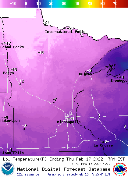
Highs Thursday will struggle to get through the single digits above zero.

A south wind Friday brings milder air to southern Minnesota where 30s return.
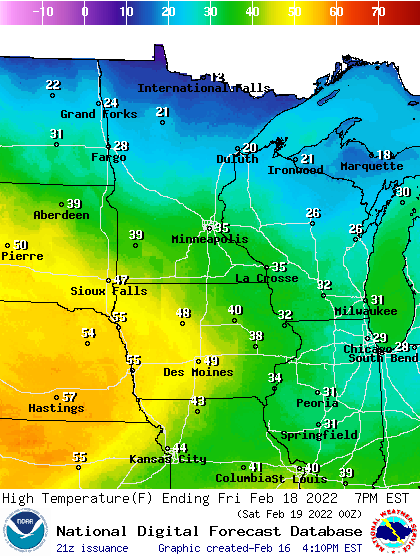
Saturday looks like a classic February day, with highs in the 20s east and 30s west across Minnesota.
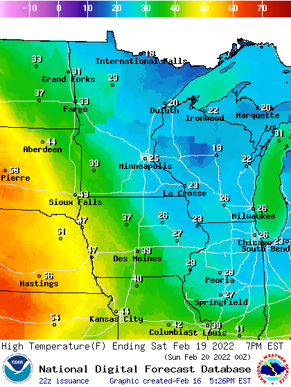
Sunday brings the milder day of the weekend. We should hit 40-plus again from the Twin Cities south and westward.

