
Pleasant Sunday weather; warming trend this week
How rare are 90s in September?
Go Deeper.
Create an account or log in to save stories.
Like this?
Thanks for liking this story! We have added it to a list of your favorite stories.


It sure feels like autumn today.
Far northern Minnesota and parts of northwestern Wisconsin had Sunday morning lows in the 30s. Lows were mainly in the 40s elsewhere in Minnesota and west-central Wisconsin. Minneapolis-St. Paul International Airport reported a Sunday low of 50 degrees, but there were a lot of 40s in the metro area. Temps will recover nicely Sunday afternoon.
Any rain chance today or Monday?
Most of Minnesota will have a rain-free Sunday and Monday. A few scattered showers could clip far southeastern Minnesota late Sunday, Sunday night and Monday.
Turn Up Your Support
MPR News helps you turn down the noise and build shared understanding. Turn up your support for this public resource and keep trusted journalism accessible to all.
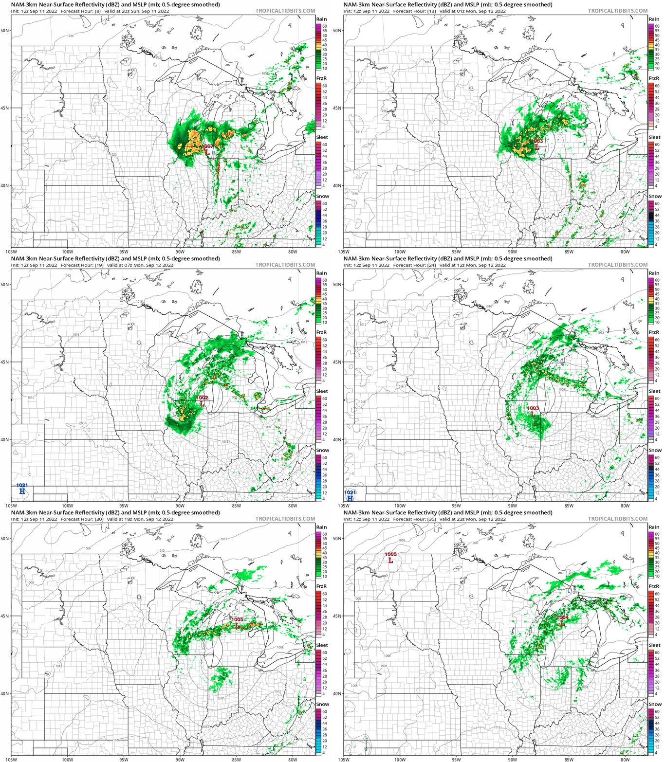
A low pressure system is spinning rain over much of southern and eastern Wisconsin today. The periods of rain will continue in those same areas into Monday. The National Oceanic and Atmospheric Administration’s North American Mesoscale (NAM) forecast model shows the potential rain pattern from 3 p.m. Sunday to 6 p.m. Monday:
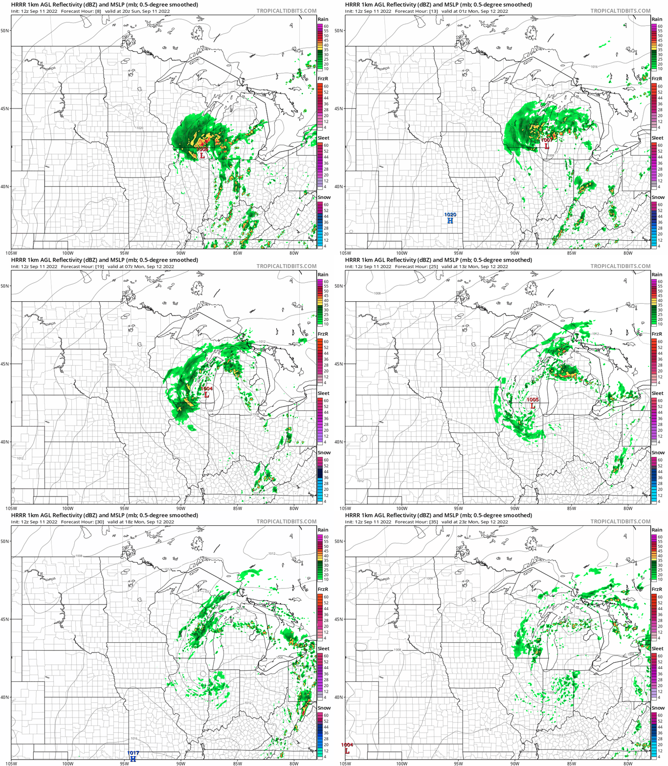
NOAA’s High-Resolution Rapid Refresh (HRRR) model shows a similar rain pattern, but indicates a better chance of Monday showers in far southeastern Minnesota:
You can track showers and thunderstorms on the new interactive radar on the MPR weather page. You can pan and zoom the radar display on our site to see rain at your location, across all of Minnesota, western Wisconsin and beyond.
We have updated weather information for Minnesota and western Wisconsin on the Minnesota Public Radio News network, and on the MPR News live weather blog.
Temperature trends
Sunday highs are forecast to reach the lower 70s across most of Minnesota and parts of west-central Wisconsin. There will be some 60s in northeastern Minnesota and far southeastern Minnesota. A Twin Cities high in the lower 70s would be a few degrees cooler than our average Sept. 11 high of 75 degrees.
Monday highs will range from the upper 70s in southwestern Minnesota to the lower 70s in northeastern Minnesota and far southeastern Minnesota:

Twin Cities metro area highs are projected to reach the mid 70s on Monday, then around 80 Tuesday and lower 80s Wednesday through Friday.
We could see above-normal temps from next weekend into the following week. The NWS Climate Prediction Center shows a tendency for above-normal temps in Minnesota and Wisconsin from Sept. 18 through Sept. 24:

Above-normal doesn’t necessarily mean hot weather in mid and late September; our average Twin Cities high temp on Sept. 18 is 72 degrees.
90s in September
Our official Twin Cities high temperature hasn’t hit 90 degrees or warmer this September. Sometimes we don’t’ have any 90s in September.
I looked at the past five Septembers, and our official Twin Cities high (measured at MSP airport) didn’t hit 90 degrees or warmer in Sept. of 2019 or 2020. MSP tallied 90 degrees or warmer on four days in Sept. of 2017, two days in Sept. of 2018 and once last September.
Three of those September 2017 highs of 90 or warmer occurred on consecutive days:

It’s a good thing that Sept. 23 and 24 were weekend days in 2017; students in schools without air conditioning had just one really hot school day that week.
Programming note
You can hear my live weather updates on MPR News at 7:35 a.m., 9:35 a.m. and 4:39 p.m. Saturday and Sunday.

