Minnesota wild weather: Blizzard warnings, big waves, ice, rain, hail
Severe weather potential across SE Minnesota

Pick your weather poison around Minnesota this week.
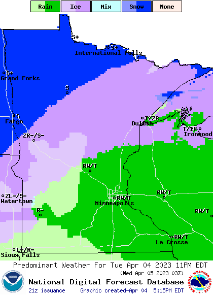
Our latest weather mess is producing a remarkable array of precipitation types across Minnesota. We’re seeing everything from heavy snow and ice to rain, thunder, hail and even a severe weather risk across Minnesota.
Check out the forecast weather and precipitation types at the top of this post. It’s not often we see such a wild variety of weather across Minnesota.
A huge 72-degree temperature contrast across the Upper Midwest is intensifying our storm.
Create a More Connected Minnesota
MPR News is your trusted resource for the news you need. With your support, MPR News brings accessible, courageous journalism and authentic conversation to everyone - free of paywalls and barriers. Your gift makes a difference.
Let’s break down the major warning and precipitation zones through Wednesday.
Blizzard and winter storm warnings north
Blizzard and winter storm warnings continue through Wednesday for areas basically north of a broken line from Fergus Falls through Brainerd to Duluth.
Highs winds of 40 to more than 50 mph will cause blowing snow and blizzard conditions in the warning zone. The heaviest snowfall totals will occur in northwest Minnesota.

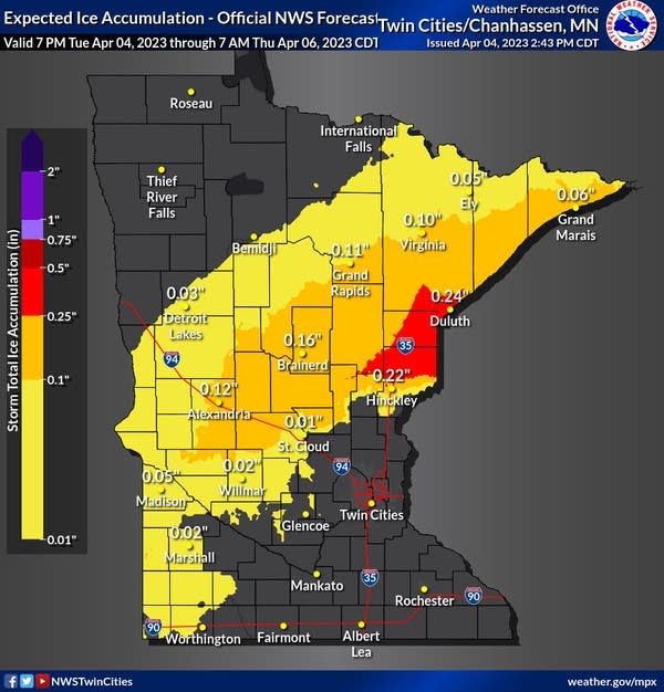
Ice storm warning includes Pine County
An ice storm warning is posted for much of northwest Wisconsin and includes Pine County in Minnesota. Up to four-tenths (.4) of an inch of ice could accumulate in this area, including along Interstate 35 near Pine City and Hinckley.

Icy roads and more power outages are likely in the warning zone.
Including the cities of Pine City and Hinckley
246 PM CDT Tue Apr 4 2023
...ICE STORM WARNING IN EFFECT UNTIL 10 AM CDT WEDNESDAY...
* WHAT...Significant icing. Additional snow accumulations of up to one inch and ice accumulations of up to four tenths of an inch. Winds gusting as high as 45 mph.
* WHERE...Pine County. This includes the Tribal Lands of the Mille Lacs Band, Lena Lake and, Hinckley areas.
* WHEN...Until 10 AM CDT Wednesday.
* IMPACTS...Power outages and tree damage are likely due to the ice. Travel could be nearly impossible. The hazardous conditions could impact the morning or evening commute.
Gale and storm warnings along Lake Superior
Winds have already gusted to 56 mph in Duluth with this system, as of this post. Gusts to 60 mph are possible.
A strong east wind with a long fetch across Lake Superior will drive waves as high as 15 to 20 feet along the North Shore, where flooding and damage are possible.
Grand Portage to Grand Marais MN- Grand Marais to Taconite Harbor MN- Taconite Harbor to Silver Bay Harbor MN- Silver Bay Harbor to Two Harbors MN-Two Harbors to Duluth MN-
411 PM CDT Tue Apr 4 2023
..STORM WARNING REMAINS IN EFFECT UNTIL 7 AM CDT THURSDAY...
* WHAT...East winds 30 to 40 kt with gusts up to 50 kt and waves 15 to 20 ft.
* WHERE...Grand Portage to Grand Marais MN, Grand Marais to Taconite Harbor MN, Taconite Harbor to Silver Bay Harbor MN, Silver Bay Harbor to Two Harbors MN and Two Harbors to Duluth MN.
* WHEN...Until 7 AM CDT Thursday.
* IMPACTS...Very strong winds will cause hazardous waves which could capsize or damage vessels and reduce visibility.
Thunderstorms and severe risk south
This potent system is strong enough to generate thunderstorms in the milder air to the south. That means rain and thunder, and a severe risk from the Twin Cities southward.

The National Oceanic and Atmospheric Administration’s High-Resolution Rapid Refresh model sows scattered storm cells developing between about 7 p.m. and midnight.

Most of the severe weather potential will be across southeastern Minnesota, Iowa, and Wisconsin. Thunder and hail are also possible around the Twin Cities metro area, especially in the east.
So expect just about anything across our region through Wednesday.