Updated rainfall totals; more showers Monday
Dry weather by midweek; 80 degrees by the weekend
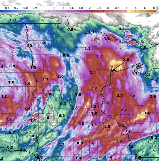
![72 hour rain](https://img.apmcdn.org/43471b7c74b4b023d04e5ea2009e2734253c8688/uncropped/c399df-20230925-72-hour-rain-532.png)
Like this?
Log in to share your opinion with MPR News and add it to your profile.
Like this?
Thanks for liking this story! We have added it to a list of your favorite stories.
Monday will bring more scattered showers and thunderstorms adding to impressive multi-day totals so far. We’ll have some lingering showers still Tuesday before we dry out and warm up.
Updated rainfall totals
Rainfall keeps adding up, although the heaviest is definitely behind us with our latest system. Rainfall between Duluth and Two Harbors is in the range of 4 to 6-plus inches, causing flooding. This is on top of the similar amounts they saw just two and a half weeks ago.
![DLH rainsss](https://img.apmcdn.org/6e8eb7003ca712e72fc164a5a2ab8393344a8c8a/uncropped/5fbc95-20230925-dlh-rainsss-2859.png)
The Duluth National Weather Service office, which saw a little less at 4.5 inches so far, is up to 9.89 inches of rain for September now.
In the Twin Cities area, the west metro saw the most with rainfall over 4 inches in several locations.
Support the News you Need
Gifts from individuals keep MPR News accessible to all - free of paywalls and barriers.
![MSP area rains](https://img.apmcdn.org/98fbf90eabffb61a81a15c7adef313a0d679a65a/uncropped/3e7ae4-20230925-msp-area-rains-2859.png)
Minneapolis-St. Paul International Airport has seen 1.72 inches so far since Friday, making it our biggest precipitation event since May 2022. This was by far the biggest, most widespread rainfall we’ve seen this year.
![72 hour rain](https://img.apmcdn.org/43471b7c74b4b023d04e5ea2009e2734253c8688/uncropped/c399df-20230925-72-hour-rain-532.png)
More showers Monday into Tuesday
We’re not done with the rain. Scattered showers and thunderstorms will continue Monday into Monday night around a slowly moving low. We’ll still have some lingering showers even on Tuesday in southern Minnesota.
![MON-tue precip 9a](https://img.apmcdn.org/edc8ee66beb9d3da512320d30cbac854958752a1/uncropped/0ee219-20230925-mon-tue-precip-9a-660.gif)
Look for cooler high temps, mostly in the 60s as well with the clouds Monday and Tuesday.
![mon hi 9a](https://img.apmcdn.org/82020fc88183c2e7bf4058c6ce21709fffd7ff9b/uncropped/a034c5-20230925-mon-hi-9a-515.png)
Brighter and warmer late week
As our slowly moving, cutoff upper-low moves out, a ridge of warmth builds in for late this week bringing back summer like temperatures to end the month. Highs by Friday and Saturday will be near 80 in southern Minnesota. We’ll also have sunshine.
![sat hi](https://img.apmcdn.org/e9117c57c7223d9bcd2dae4b00cc6cab17ee1912/uncropped/71c2df-20230925-sat-hi-515.png)