Updraft®

Mild pattern continues; some snow showers possible this weekend

November was mild, as was Minnesota's entire meteorological fall

FCST
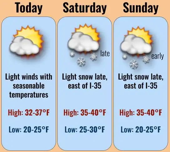
Twin Cities area forecast through the weekend
National Weather Service

Friday will be a little cooler and we’ll have more clouds around for the afternoon into the weekend. A few snow showers are possible Saturday night.

Looking back, Minnesota’s November was mild, as was the entire meteorological fall.

Slightly cooler Friday with some weekend snow showers

Friday will be slightly cooler than the last couple of days but still near or slightly above normal. Look for some high and mid-level clouds to increase heading into the afternoon. 

fri hi 8a
Forecast highs Friday
National Weather Service

The weekend will bring more of the same with temperatures mostly in the 30s ranging from the low 30s in northern Minnesota to near 40 degrees at times in southern Minnesota. 

sat-sun highs
Forecast high temperatures Saturday and Sunday
National Weather Service

While the bulk of the weekend storm system will stay south and east of Minnesota, we’ll see at least some scattered rain and snow showers possible in the eastern part of the state. Light accumulations are possible in parts of southeastern Minnesota and northeast in the state’s Arrowhead region.

The graphic below shows the official snowfall forecast but also the high end (1 in 10 chance) possible snowfall:

snowfall
Forecast snowfall (left) and high-end forecast amounts (right)
National Weather Service

Next week will continue the mild pattern with highs mainly in the 40s in southern Minnesota. 

A mild November and meteorological fall 

Meteorological fall and November are in the books for 2023. It was mild on both accounts. November was near normal only in northeastern Minnesota. For most of the state, temperatures were anywhere from 1 to 4 degrees above normal. 

NOV T anom
November temperature anomalies (departure from normal)
Midwest Regional Climate Center

In the Twin Cities, we finished nearly 4 degrees above normal, making it about the 18th warmest November on record. In Duluth, it was just over 2 degrees above normal. It was also a very dry month for all but northeastern Minnesota.

Parts of southwestern Minnesota saw little or no precipitation at all while northeastern Minnesota saw about 75 percent of normal precipitation.

% normal precip NOV
Percent normal precipitaiton for November
Midwest Regional Climate Center

Snowfall was also lacking across most of the state. The vast majority of Minnesota saw under 1 inch of any snowfall while northeastern Minnesota saw anywhere from 1 to 5 inches. 

NOV snowfall
Total November snowfall
Midwest Regional Climate Center

Statewide snowfall was well below normal. In the Twin Cities, normal November snowfall is 6.7 inches and we saw just one-half inch. Duluth, which should see 13.6 inches of snow in November, saw only 1.1 inches.

% norm snow NOV
Percent normal snowfall for November
Midwest Regional Climate Center

For the big picture of meteorological fall, which is the period of Sept. 1 through Nov. 30, it was very warm. In the Twin Cities it was our fourth warmest fall and in Duluth it was the 11th warmest. Four of the top five spots for the Twin Cities are just since 2015. 

For those keeping track, recall that was September was the hottest on record and summer was the fifth hottest. Year to date we’re running the seventh warmest ever of 150 years in the Twin Cities.

December could very well push us up in the rankings since it’s forecast to be another mild month thanks to the El Niño pattern that’s entrenched. 

dec outlook
December temperature outlook
National Oceanic and Atmospheric Administration's Climate Prediction Center